Ancient Mariners of the Mediterranean
With 95 percent of the seafloor not yet explored, oceanographers and maritime archaeologists look to the deep waters of the Mediterranean and Aegean seas for shipwrecks that can be used to tell the story of ancient civilizations throughout the region.
Anthropology, Earth Science, Oceanography, Social Studies, Economics, World History

The study of oceanography brings many different fields of science together to investigate the ocean. Despite increased research and advances in technology , the depths of the ocean remain mostly unexplored. Archaeology is the study of human history using the material remains, or artifacts , of a culture. Artifacts help reveal a particular group’s culture, including their economies, politics, religions, technologies, and social structure. Maritime, or underwater, archaeologists study artifacts and sites submerged in lakes, rivers, and the ocean. While many land-based archaeological finds have already been studied, the ocean depths contain countless new sites and artifacts yet to be discovered.
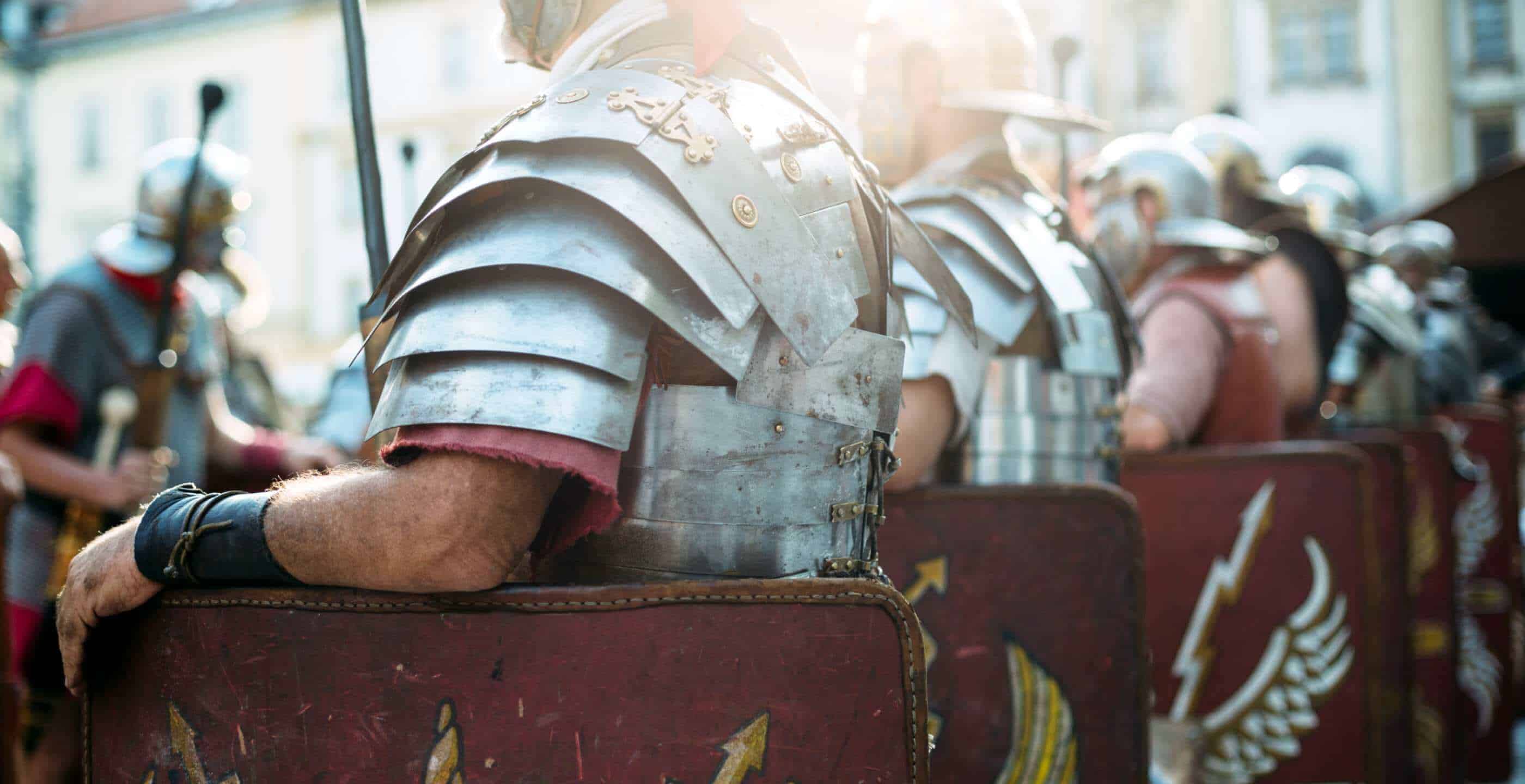
As ancient people began to develop civilizations , or urban settlements with complex ways of life, extensive trade routes formed throughout the Mediterranean. The eastern Mediterranean and Aegean seas formed an important crossroads of trade and travel in the ancient world. By exploring shipwrecks from this region, researchers learn more about the people who lived there throughout history, as far back as 1000 B.C.E ., when Greek civilization was on the rise. Oceanographer Dr. Robert Ballard works with maritime archaeologists to explore ancient shipwrecks throughout the Mediterranean. By studying these ancient wrecks, the history and culture of the region’s ancient civilizations can be better understood.
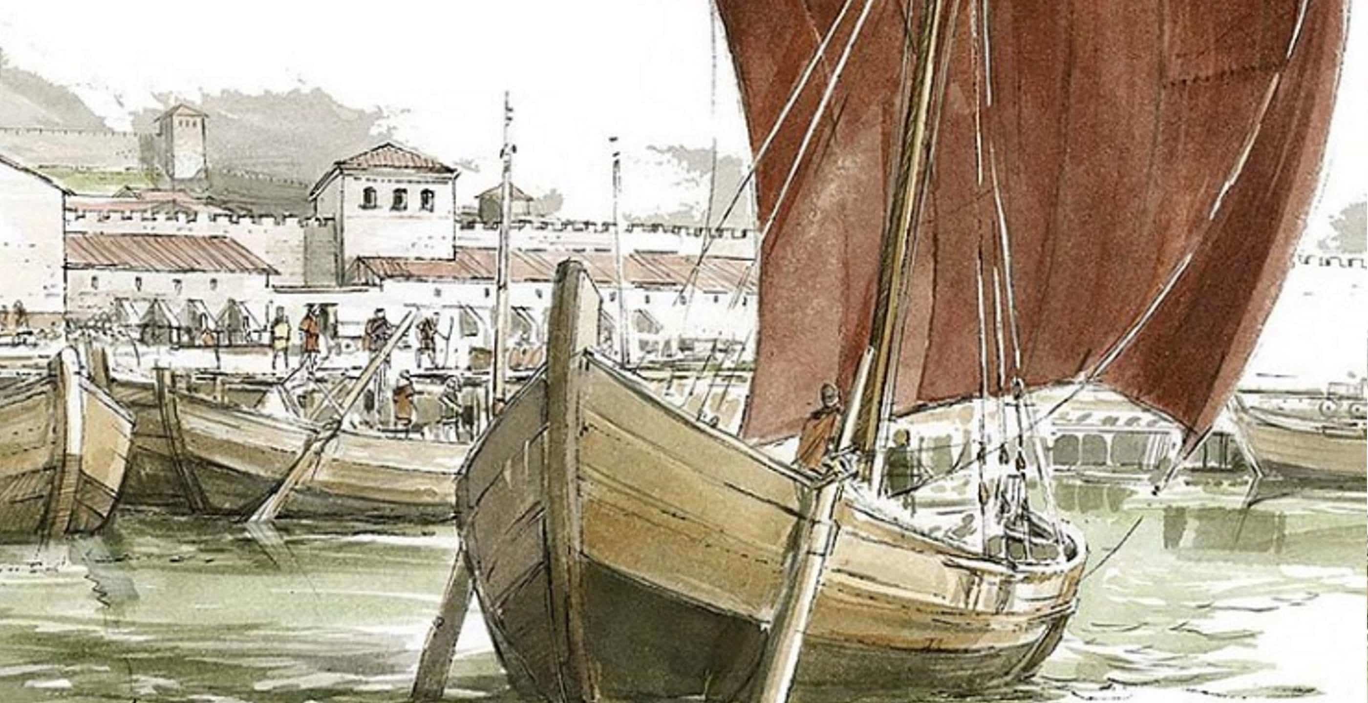
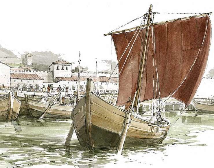
Finding and excavating ancient shipwrecks in the deep o cean requires the use of advan ced technology , including sonar and ROVs . On ce wrecks are located using sonar , ROVs with cameras are used to observe them. One way to determine the historical time period the shipwreck came from is to identify key artifacts . In the ancient world of the Mediterranean region, one such key artifact is an amphora , a clay jar that was used to transport goods like olive oil, grain, and wine. By viewing video footage captured by the ROVs , expert archaeologists observe the shape and style of the amphorae to determine approximately where and when they were used. The shape of an amphora ’s base can vary from well-rounded or barrel-shaped to conical. Its neck can appear separate from the base or as one continuous pie ce . An amphora ’s handles can fall vertically or be more rounded. The stamps and designs, such as ribbing, used on amphorae indicate different regions and time periods in which the jars and their contents came.
Using archaeological evidence, including amphorae, scientists determined that most of the shipwrecks found in the Mediterranean region are from the C.E. , being no more than 2,000 years old. That makes shipwrecks like the one Ballard’s team discovered in the deep Aegean Sea such a remarkable find. Based on the ribbed, conical-shaped amphorae from the wreck, the ship was likely transporting goods to and from the Greek island of Samos during the Archaic period of Greece (seventh century B.C.E.), says archaeologist and ceramics expert Andrei Opait. This was two hundred years before the Classical period of Greece (fifth century B.C.E.), when Plato and Socrates were living and Greek maritime power dominated the region. If Opait’s theory is correct, the wreck would be the oldest ship ever discovered in the Aegean Sea. According to Ballard, this shipwreck is just one of thousands yet to be discovered in the depths of the Mediterranean.
- The average depth of the Mediterranean Sea is 3,000 meters (9,840 feet), with its deepest point at approximately 5,000 meters (16,400 feet).
- When broken down into its Greek root words, the term “archaeology” literally means “study of the ancient,” from arkhaios, meaning ancient, and logia, meaning study of.
- The excavation of the Cape Gelidonya shipwreck off the south coast of Turkey in the 1960s was an important event for the field of maritime archaeology for three main reasons: It was the first excavation where the supervising archaeologist, George Bass, both dove to and excavated a site; it was the first time where land-based archaeological techniques were adapted for the underwater environment; and it was the first shipwreck to be entirely excavated.
- The Nautilus Expedition uses state-of-the-art remote sensing and satellite communication technology to connect researchers across the globe. These technologies allow researchers at sea aboard the E/V Nautilus to send data and high-definition images to the Inner Space Center (mission control) in Rhode Island within 1.5 seconds.

Audio & Video
Media credits.
The audio, illustrations, photos, and videos are credited beneath the media asset, except for promotional images, which generally link to another page that contains the media credit. The Rights Holder for media is the person or group credited.
Last Updated
October 19, 2023
User Permissions
For information on user permissions, please read our Terms of Service. If you have questions about how to cite anything on our website in your project or classroom presentation, please contact your teacher. They will best know the preferred format. When you reach out to them, you will need the page title, URL, and the date you accessed the resource.
If a media asset is downloadable, a download button appears in the corner of the media viewer. If no button appears, you cannot download or save the media.
Text on this page is printable and can be used according to our Terms of Service .
Interactives
Any interactives on this page can only be played while you are visiting our website. You cannot download interactives.
Related Resources
- Advertise with us
- History Magazine
- History of England

Gaul To Britannia, The Crossing of Oceanus Britannicus
Sea travel in ancient times could be a dangerous business and crossing Oceanus Britannicus was particularly hazardous with its unpredictable weather conditions…
Laura McCormack
Sea travel in ancient times could be a dangerous business and travelling into unfamiliar territory and the uncertainty of what might be encountered, a perilous affair. The shores of Gaul were once considered as being at the end of the world and almost another world. Accounts of Emperor Claudius’ legions on the eve of his invasion of Britain in 43 A.D., tells of them at first flatly refusing to face a voyage to Britannia, this place outside the world with its dangers of being wrecked or castaway on a hostile shore. Although Julius Caesar in 55 B.C. had shown that an invasion across Oceanus Britannicus from Gaul was feasible, Claudius’ army may still have feared that anyone travelling that far could fall off the edge of the earth.
Following the conquest, Britannia became a Roman province. As a province it developed a number of ports to handle the increase in shipping, including Portus Dubris (Dover), Portus Rutupiae (Richborough), Portus Lemanis ((Lympne) and in Gaul, Gesoriacum. Gesoriacum developed around an expanding port and linked the continent to Britannia. The sea journey across Oceanus Britannicus (the English Channel) from Gesoriacum to the port of Rutupiae in Britannia (Richborough, Kent) was recorded in the Antonine Itinerary as a distance of four-hundred and fifty stadia, 56.25 Roman miles. This was the most direct route to Britannia. It is thought that three hundred and fifty stadia would be closer to the actual distance, however the need to navigate hazards in the channel could account for the the extra one hundred stadia recorded in the Itinerary. Depending on the weather, the journey across the channel to Britannia could take a ship six to eight hours.
For those travellers who were accustomed to sailing the Mediterranean, the weather conditions they could encounter on Oceanus Britannicus would be considerably more hazardous. Oceanus Britannicus was known for its precarious waters, with massive tides and currents accompanied by variable winds which could make for a difficult crossing. The channel during the winter is far more prone to violent winds than the stormiest region of the Mediterranean. Although the frequency of powerful winds blowing through the channel is greatly reduced during the summer, modern records suggest that ships sailing between Britain and the continent in July still expect to encounter strong or gale force winds on two percent of occasions. In the Mediterranean, tides are hardly perceptible in comparison to tides around the coast of Britain, which can rise and fall anywhere between 1.5 to 14 meters twice daily. Romans made ships for these harsher conditions which would withstand the tidal waters of the north western hemispere. Ships were designed with high bows and sterns to protect against heavy seas and storms. These vessels were also built flat bottomed, enabling them to ride in shallow waters and on ebb tides.
Navigation across the channel was aided by pharos. The lighthouse Tour d’Ordre at Gesoriacum and on the opposite coastline, a pair of pharos, momumental structures at a height of over twenty metres, were situated on the headland flanking either side of the major port of Dubris. The remains of one of these lighthouses survives within Dover Castle. The Romans also maintained a fleet, the Classis Britannica, present in the channel from the 1st century A.D. which provided security for crossing vessels. The fleets purpose was to transport men and supplies and patrol the channel keeping the sea routes free of pirates. The fleet with its headquarters in Gesoriacum, the major Roman naval base for the north of the Empire, also had a permanent base at Dubris (Dover) and Lemannis (Lympne).

On arrival in Gaul at the port in Gesoriacum, a traveller would find himself in the midst of a hub of activity: merchant ships and naval vessels in the harbour and the busy shipyards carrying out repairs and maintenance. Journey plans for crossing Oceanus required flexibility. There was no routine sailings and to organise his passage the traveller would set about finding the next available ship. He would also need to be aware that not only unsuitable weather conditions prevented sailings, also on ill-omened days; on dates such as the 24 August, 5th October and 8th November, no ship would leave port. Once the next available sailing was found, a deck passage would be booked with the master of the ship, the magister navis.
Ships were merchant vessels not given over to comforts for those passengers on board. There were no cabins, although sometimes small tent-like shelters were used. Before sailing, the ships authorities would always carry out the pre-sailing sacrifice to the gods of a sheep or a bull at the harbour’s temple. Larger ships might have had an altar and a sacrifice could be made on board. If the omens were not right, the sailing would be delayed, positive signs combined with good weather ensured departure. The traveller, anxious for his own personal protection, might also have appealed to Mercury, the god of safe travel. Julius Caesar wrote that Mercury was the most popular god in Gaul and Britannia. One common practice for protection was to wear a brooch depicting a cockerel, herald of each new day, which was associated with the god.
Ancient sea journeys could be uncomfortable and fearful. Once on board, the traveller might settle his nerves and occupy himself by talking with other passengers or perhaps by watching the handling of the vessel; the helmsman guiding the ship, pushing and pulling on the tiller bars or the sailors trimming the lines of the main sail and the deckhands carrying out their duties.
The journey across Oceanus Britannicus with all its possible hazards was nevertheless, a relatively short crossing. On a fine day, there would be a clear and comforting view of Britannia. Approaching the coast of this remote province, the high chalk cliffs of Dover towered, “stupendous masses of natural bulwarks,” was how they were described by one Roman general. For the traveller it must have been a very welcoming sight.
History in your inbox
Sign up for monthly updates
Advertisement
Next article.
Roman Sites in Britain
Browse our interactive map of Roman sites and remains in England, Scotland and Wales.
Popular searches
- Castle Hotels
- Coastal Cottages
- Cottages with Pools
- Kings and Queens
- Share full article
Advertisement
Supported by
On Crete, New Evidence of Very Ancient Mariners

By John Noble Wilford
- Feb. 15, 2010
Early humans, possibly even prehuman ancestors, appear to have been going to sea much longer than anyone had ever suspected.
That is the startling implication of discoveries made the last two summers on the Greek island of Crete. Stone tools found there, archaeologists say, are at least 130,000 years old, which is considered strong evidence for the earliest known seafaring in the Mediterranean and cause for rethinking the maritime capabilities of prehuman cultures.
Crete has been an island for more than five million years, meaning that the toolmakers must have arrived by boat. So this seems to push the history of Mediterranean voyaging back more than 100,000 years, specialists in Stone Age archaeology say. Previous artifact discoveries had shown people reaching Cyprus, a few other Greek islands and possibly Sardinia no earlier than 10,000 to 12,000 years ago.
The oldest established early marine travel anywhere was the sea-crossing migration of anatomically modern Homo sapiens to Australia, beginning about 60,000 years ago. There is also a suggestive trickle of evidence, notably the skeletons and artifacts on the Indonesian island of Flores, of more ancient hominids making their way by water to new habitats.
Even more intriguing, the archaeologists who found the tools on Crete noted that the style of the hand axes suggested that they could be up to 700,000 years old. That may be a stretch, they conceded, but the tools resemble artifacts from the stone technology known as Acheulean, which originated with prehuman populations in Africa.
More than 2,000 stone artifacts, including the hand axes, were collected on the southwestern shore of Crete, near the town of Plakias, by a team led by Thomas F. Strasser and Eleni Panagopoulou. She is with the Greek Ministry of Culture and he is an associate professor of art history at Providence College in Rhode Island. They were assisted by Greek and American geologists and archaeologists, including Curtis Runnels of Boston University.
Dr. Strasser described the discovery last month at a meeting of the Archaeological Institute of America . A formal report has been accepted for publication in Hesparia, the journal of the American School of Classical Studies at Athens, a supporter of the fieldwork.
The Plakias survey team went in looking for material remains of more recent artisans, nothing older than 11,000 years. Such artifacts would have been blades, spear points and arrowheads typical of Mesolithic and Neolithic periods.
“We found those, then we found the hand axes,” Dr. Strasser said last week in an interview, and that sent the team into deeper time.
“We were flummoxed,” Dr. Runnels said in an interview. “These things were just not supposed to be there.”
Word of the find is circulating among the ranks of Stone Age scholars. The few who have seen the data and some pictures most of the tools reside in Athens said they were excited and cautiously impressed. The research, if confirmed by further study, scrambles timetables of technological development and textbook accounts of human and prehuman mobility.
Ofer Bar-Yosef, an authority on Stone Age archaeology at Harvard, said the significance of the find would depend on the dating of the site. “Once the investigators provide the dates,” he said in an e-mail message, “we will have a better understanding of the importance of the discovery.”
Dr. Bar-Yosef said he had seen only a few photographs of the Cretan tools. The forms can only indicate a possible age, he said, but “handling the artifacts may provide a different impression.” And dating, he said, would tell the tale.
Dr. Runnels, who has 30 years’ experience in Stone Age research, said that an analysis by him and three geologists “left not much doubt of the age of the site, and the tools must be even older.”
The cliffs and caves above the shore, the researchers said, have been uplifted by tectonic forces where the African plate goes under and pushes up the European plate. The exposed uplifted layers represent the sequence of geologic periods that have been well studied and dated, in some cases correlated to established dates of glacial and interglacial periods of the most recent ice age. In addition, the team analyzed the layer bearing the tools and determined that the soil had been on the surface 130,000 to 190,000 years ago.
Dr. Runnels said he considered this a minimum age for the tools themselves. They include not only quartz hand axes, but also cleavers and scrapers, all of which are in the Acheulean style. The tools could have been made millenniums before they became, as it were, frozen in time in the Cretan cliffs, the archaeologists said.
Dr. Runnels suggested that the tools could be at least twice as old as the geologic layers. Dr. Strasser said they could be as much as 700,000 years old. Further explorations are planned this summer.
The 130,000-year date would put the discovery in a time when Homo sapiens had already evolved in Africa, sometime after 200,000 years ago. Their presence in Europe did not become apparent until about 50,000 years ago.
Archaeologists can only speculate about who the toolmakers were. One hundred and thirty thousand years ago, modern humans shared the world with other hominids, like Neanderthals and Homo heidelbergensis. The Acheulean culture is thought to have started with Homo erectus.
The standard hypothesis had been that Acheulean toolmakers reached Europe and Asia via the Middle East, passing mainly through what is now Turkey into the Balkans. The new finds suggest that their dispersals were not confined to land routes. They may lend credibility to proposals of migrations from Africa across the Strait of Gibraltar to Spain. Crete’s southern shore where the tools were found is 200 miles from North Africa.
“We can’t say the toolmakers came 200 miles from Libya,” Dr. Strasser said. “If you’re on a raft, that’s a long voyage, but they might have come from the European mainland by way of shorter crossings through Greek islands.”
But archaeologists and experts on early nautical history said the discovery appeared to show that these surprisingly ancient mariners had craft sturdier and more reliable than rafts. They also must have had the cognitive ability to conceive and carry out repeated water crossing over great distances in order to establish sustainable populations producing an abundance of stone artifacts.
Royal Navy Ship HMS Trent Seizes Cocaine Worth £40 Million In The Caribbean Sea

Seafarers Hospital Society Launches Pilot Project To Support Women At Sea

Hydrocell Launches The First Hydrogen-Powered Boat

Indian Port Workers Call Off Strike After Agreeing To New Wage Settlement

The History of Ships: Ancient Maritime World
The ships we come across nowadays are large, sturdy and self propelled vessels which are used to transport cargo across seas and oceans. This was not the case centuries ago, and the current ship has undergone countless centuries of development to become what it is today.
In ancient marine times, people used rafts , logs of bamboo, bundles of reeds, air filled animal skins and asphalt covered baskets to traverse small water bodies. To be precise, the first boat was a simple frame of sticks lashed together and covered expertly with sewn hides. These boats could carry large and heavy loads easily. You get to know about examples of such ancient boats among the bull boats of North American plains, the kayaks of the Inuit’s and the coracks of British islanders. Yet another ancient boat was the dugout which is a log that is hollowed out and pointed at the ends. Some of these were even as long as sixty feet. Here is a brief attempt to traverse lightly over the history of ships and how they evolved to what they are now.
The Usage of Poles and Invention of Oar
Ancient marine history makes for quite an interesting study of the strength and survival instincts of humanity at large. For instance, in ancient times, the simple oar was not in use. Instead people used their hands to paddle along in their tiny boats. They moved rafts by pushing poles against the bottom of the rivers. Slowly, using creative instincts and ingenuity, man learnt to redesign the poles by flattening them and widening it at one end, and thus the paddle was designed to be used in deeper waters. Later on, it was again ingeniously transformed to become the oar-a-paddle that is fixed on the sides of boats.

Invention of Sails
The invention of the sail was the greatest turning point in maritime history. The sails replaced the action of human muscles and sail boats could embark on longer trips with heavier loads. Earlier vessels used square sails that were best suited for sailing down wind. Fore and aft sails were devised later.
Egyptians take the credit for developing advanced sailing cargo ships. These were made by lashing together and sewing small pieces of wood. These cargo ships were used to transport great columns of stone for monument building.
Phoenicians and their Contribution
History of ships is never complete without mentioning the Phoenicians. They deserve special mention since it is highly probable that they were the pioneers of the wooden sailing vessels that were to sail the high seas centuries later. The Phoenicians fashioned out galleys from the earlier dugouts with sails and oars providing power. As the galleys grew larger, according to specifications and requirements, rowers were arranged at two levels.
These were called the biremes by the Greeks and Romans. They also built triremes that are galleys with three banks of oars.
Types of Ships in Ancient Maritime History
As marine history and along with it, the history of ships unfolds; it draws images of intrigue and amazement at the expert and diligent craftsmanship of the ancient mariners. The medieval ships were clinker built, which refers to the clenching of nail -on technique used for securing planks. The clinker design was adapted from the earlier skin boats which had to be over lapped to make it water tight.
The Irish, in the medieval ages were in possession of more advanced vessels like the Irish curragh. These had wooden frames and a hide covered wicker hull; it is speculated that these ancient ships were fitted with removable masts rigged using primitive sails.
By 1000 AD, the famed Viking Long ship was permitted a travel into the Mediterranean. These ships were wider and had a more advanced mast stepping design.
By 800 AD an alternative form of the north European ship design, the hulk came into vogue. The Utrecht ship is an example of the hulk. Its planks are flush, butted end to end and tapered in order to draw up at the sides and at the bow and stern.
I mprovements in Marine Vessels
Ships continued to develop as overseas trade became increasingly more important. By late 1100’s a straight stern post was added to ships to facilitate the hanging rudder. This aspect improved greatly the handling characteristics of a ship. The rudder permitted larger ships to be designed. It also allowed for ships with increasingly higher free boards to be built.
As years passed, in order to avoid risk of water damage, cargo was transported in large gallon barrels called tuns. The crew could now sleep on big leather bags on deck; the passenger space was termed “steerage” and this term is still in use today to refer to passenger accommodation of minimal facilities.
The British relied heavily on the nef, a term used for ships. At this point of time, ship design took a different turn – the first distinctive feature was the plank on frame construction. This allowed for much larger ships to be built. With more ships at sea, trade occurred from nearly all ports and there arose a need for a ship that could sail from anywhere to anywhere.
The carrack was designed and she was truly one of the tall ships. It has its origin in Genoa and sports the design of three Mediterranean vessels set to sail north through the Atlantic trade in the Bat of Biscay. The carrack was almost exclusively built of carvel, a type of construction that had its uses in both skin and frame built ships. In this design, the planks are fitted edge to edge rather than overlapping. In fact the carrack was the first to use the full skeletal design with planking framed on ribs the entire way to the keel.
You may also like to read-
- The Unique Tradition of Ship Burial & the Sutton Hoo Ship Burial
- Top 10 Historic Ships of All Time
Disclaimer : The information contained in this website is for general information purposes only. While we endeavour to keep the information up to date and correct, we make no representations or warranties of any kind, express or implied, about the completeness, accuracy, reliability, suitability or availability with respect to the website or the information, products, services, or related graphics contained on the website for any purpose. Any reliance you place on such information is therefore strictly at your own risk.
In no event will we be liable for any loss or damage including without limitation, indirect or consequential loss or damage, or any loss or damage whatsoever arising from loss of data or profits arising out of, or in connection with, the use of this website.

Do you have info to share with us ? Suggest a correction
Daily Maritime News, Straight To Your Inbox
Sign Up To Get Daily Newsletters
Join over 60k+ people who read our daily newsletters
By subscribing, you agree to our Privacy Policy and may receive occasional deal communications; you can unsubscribe anytime.

BE THE FIRST TO COMMENT
For marine history: would a galley under sail gain speed or stability on course by also rowing? I see historic images of both modes combined in operation, mostly for small galleys. Thanks in advance, C. Carrillo
Hello, I have discovered two saleable formulae as an internationally recognizable scientist. Both of them had ever been verified in Germany very well. One is derived for the decarbonation of soft drinks and another for a technology of dry cell driven cruisers. I would formally sell two discoveries at mere deserved prices when authentic dealers were become available in the world. My friendly inquiry with you has been if you wish to help in this mission whatsoever on timely. Thank you very much, sincere regards, Prof. Roshan Adhikari.
Minimalist. Far to much to be said
what is boat?
What sources as in researchers, libraries, museums, archives have a collected history on the ancient practices of shipping of livestock? Zeng He in the 15th century transported wild animals. There are, of course, much earlier records of Chinese exploration (2 BC, e.g.) I am interested in the care of the animals and the loading and unloading practices.
@Jimmy: This article might be helpful – https://www.marineinsight.com/types-of-ships/7-differences-between-a-ship-and-a-boat/
Evolution of ships flowchart.
It always frustrates me how “ancient maritime history” are so western-centric and completely ignore the oldest sailing cultures in the world: the Austronesians. Even when they do mention it, they only mention the Polynesians and ignore all the rest. Heck, even the crab-claw sail used by most sport sailing boats today are continually misidentified as “lateen” sails. They literally are the first humans to invent ships that could cross oceans. Doing it almost 1500 years before Phoenicians, and they did it in the open oceans of BOTH the Pacific and the Indian oceans, not the relatively protected waters of the Mediterranean. Austronesians colonized places as far apart as Madagascar and Easter Island before the colonial era. The technologies they invented like fore-and-aft sails, outriggers, and multhull ships are now used on almost all modern high-speed sailing and commercial/military ships. They deserve more attention.
Leave a Reply
Your email address will not be published. Required fields are marked *
Subscribe to Marine Insight Daily Newsletter
" * " indicates required fields
Marine Engineering
Marine Engine Air Compressor Marine Boiler Oily Water Separator Marine Electrical Ship Generator Ship Stabilizer
Nautical Science
Mooring Bridge Watchkeeping Ship Manoeuvring Nautical Charts Anchoring Nautical Equipment Shipboard Guidelines
Explore
Free Maritime eBooks Premium Maritime eBooks Marine Safety Financial Planning Marine Careers Maritime Law Ship Dry Dock
Shipping News Maritime Reports Videos Maritime Piracy Offshore Safety Of Life At Sea (SOLAS) MARPOL
Ancient Mariners: Transoceanic Voyages Before the Europeans
- Read Later
The idea that humans have been completing transoceanic voyages - traveling the earth via our oceans - before Europeans set sail is, in many people's eyes, an accepted conclusion. Yet it is still debated , resisted, and rejected in many academic circles.
We have seen the work of Hapgood, who theorized a pre-ice age tradition of world mapping which involved an advanced, unknown sea-faring civilization who possessed astonishing abilities. Hapgood based these claims on decades of research into ancient map fragments; the most famous of which, the “Piri Reis” map dating to the 15th century, is believed by him and his team to show the Princess Martha Coast of Queen Maud Land Antarctica and the Palmer Peninsula.

Map of the world by Ottoman admiral Piri Reis, drawn in 1513 but allegedly based on much older maps. ( Public Domain )
Astonishing in itself, the fact that the fragment also appears to show the coastline free of ice is downright spectacular considering, according to research presented by Hapgood, the last time it was ice free was over 6,000 years ago (Hapgood, 1966, P. 93-98). Thus, when we consider an oceanic link say, between South America and the Pacific Islands, it should not be too hard to fathom.
In the realm of physical testing, a famous 1947 expedition saw Norwegian adventurer and ethnographer Thor Heyerdahl set off from Peru to French Polynesia in nothing more than a raft designed and constructed using local materials and techniques.
- Evidence Accumulates for Ancient Transoceanic Voyages, Says Geographer
- Amerigo Vespucci: The Forgotten Explorer Who Named America

The Kon-Tiki Expedition Across the Pacific Ocean by balsa wood raft (1947). (cesar harada/ CC BY NC SA 2.0 )
Yes, Heyerdahl’s journey was a crazy one. Having based most hopes of survival on descriptions of traditional ancient crafts from the indigenous people, the intrepid sea-going adventurer and his five man crew were aiming to prove that trans-oceanic voyages from South America to the Pacific Islands was possible and, after 101 days in treacherous Pacific currents, sailing over 8,000 kilometers (5,000 miles) through barren stretches of nothing but water for as far as the eye can see, the washed-out crew finally broke land in the Tuamotus archipelago in French Polynesia, proving once and for all this trans-Pacific travel was indeed possible.
Heyerdahl’s journey was undisputable. The fact that his boat was constructed in the most basic manner possible simply adds to the notion that even at its most simple form, the notion of trans-oceanic voyage should not be dismissed.
Heyerdahl’s theories on how the people of the Pacific Islands arrived via migration from South America, however, was disputed. Nevertheless, this was in the mid-20th Century and, as of 2014, the U.K’s Independent reported findings that may add support to some of Heyerdahl’s long-put down theory. The discovery of two ancient skulls in Brazil, specifically linked to the indigenous Botocudo peoples, provided the opportunity for genetic testing to be carried out by the Natural History Museum of Denmark; and the results, published in a peer-reviewed journal, suggest the skulls’ “ genomic ancestry is Polynesian , with no detectable Native American component” (Malaspinas, A. S. et al., 2014).
While the possibility that the genetic make-up of skulls was due to “mediated European transport,” the true age of the genetic lineage remains unclear. I believe this may in fact hint to what Heyerdahl had claimed all those decades before - a pre-European expansion across the Pacific.
On the Trail of Early Trans-Pacific Voyagers
If we were to ask: who could have been sailing at this distant time? - evidence like the “Gwion Gwion” rock art of the Kimberley region , located in the isolated western side of Australia, certainly depicts indigenous people using small boats to pass over open stretches of water. Heyerdahl showed that in this manner they could undergo long-distances.

“Gwion Gwion” rock art depicting a boat, Kimberley, Australia. ( Classconections )
This still does not explain the advanced map fragments. Accurate enough to be better than almost all “modern” maps pre-1900, we see no real evidence for writing-based systems in most of these subsistence-living style cultures who utilized small, human-powered boats. These ancient maps required expertise in the skills of geometry, geography, and a system to efficiently log all of this information.
The skills needed to create these maps must have come from somewhere, but where?
In my previous article, I discussed the fleeting possibility that the Acropolis' initial habitation and construction phases were actually the result of an ancient sea-faring culture, one that many contemporary independent researchers have been on the trail of for years, one who was not only at the heart of the archaic Greek's civilizations during their "golden age", but at the hearts of civilizations across the world - linking North Africa from Egypt to the Anatolian plains through Gobekli Tepe, out through Eurasia by way of Siberia into Europe, and far beyond.
Coincidentally, early 19th century travelers like the English-born doctor and ethnographer Edward Shortland recorded many of the Polynesian and Pacific Island foundation myths (specifically those from New Zealand and Cook Islands Māori population , the Tuamotu archipelago, and Marquesan in French Polynesia) and the locals all tell of how their own sea-faring cultures were created with the help of a first man: “Tiki”. One local told how:
“Tiki taught laws to regulate work, slaying, man-eating: from him men first learnt to observe laws for this thing, and for that thing, the rites to be used for the dead… and other invocations very numerous.” (Shortland, 1882, P. 2)

French Polynesia Tahiti Carved Stone Tiki Statue . ( Tom Nast /Adobe Stock)
While the name changes somewhat, the figures description remains similar whatever island you end up on. Being symbolically connected to the water, Tiki is in the same vein as Oannes in the Middle East, Manu in the Indian subcontinent, Osiris and his followers in North Africa and Quetzalcoatl and Viracocha in the Americas, and the list could keep going on.
It is certainly curious that during the aforementioned Danish study, further testing of over 27 native Rapanui (Easter Islanders) DNA had concluded the genomes were on average about eight percent Native American, suggesting at one time the Rapanui and Native American people had been close in contact.
Again, it is hard to know whether this genetic link was pre or post-European voyage, but maybe certain stone figures from the Pacific Islands - aside from the now world-renowned Easter Island heads - smaller, lesser known sculptures, may hold a clue to where this connection spread from.

The now world-famous, gigantic Easter Island “Moai” heads - most are accompanied with even larger bodies buried under the ground. ( Public Domain )
Stories Set in Stone
Many countries situated around the Pacific Ocean seem to draw parallels with one another, suggesting at one time there was at least one common connection between these amazing yet still so unknown settlements. This can also be seen throughout ancient sculpture.
The meaning behind the “dogu” is still unclear, but it is known that these mysterious Neolithic stone figurines appeared during the Jomon Period within ancient Japan, a strange and undoubtedly unknown time, starting around 14,500 BC and ending close to 1000 BC. The level of detail found in some dogu suggests an exceptional skill of craftsmanship - some are even completely hollow but still able to stand freely on their own.
Theories range on their purpose. The Japanese Times reports how some researchers believe artifacts such as these were designed as “play toys”... the prevalent theory before this was that they were simply ritualistic offerings. Dr. Kaner, an archaeologist specializing in prehistoric Japan from the Sainsbury Institute for the Study of Japanese Arts and Cultures believes “there is scope for both ‘everyday’ figures and objects of veneration within the dogu tradition.”

Dogū (clay figure), Jomon period, 7000-400 BC, Tokyo National Museum. ( CC0 )
The truth is, nobody really knows what these artifacts were used or designed for. Many researchers tend to believe they often represent real historical figures, used to venerate people whom the local population looked up to. This certainly makes sense. From the Egyptians to the Romans, and even in our modern times, we seem to have a penchant for creating large stone sculptures of historical figures we want to idolize.
We know that to be the case with the civilizing figure Tiki, who was traditionally immortalized through stone sculptures found throughout the numerous Polynesian and Pacific islands, thought to have originally represented this civilizing figure himself. In fact, some Polynesian depictions of the founding hero Tiki draw eerily similar senses of artistry to the mysterious dogu figures of prehistoric Japan.
- Mysterious Cocaine Mummies: Do They Prove Ancient Voyages Between Egypt and Americas?
- Adrift at Sea: The Long-Awaited Recovery of the Oldest Message in a Bottle
Pacific Passageways and Tiki
When compared side-by-side, there seems to be an, albeit small, stylized similarity between the “goggle-eyed” dogu from Kamegaoka, the Tōhoku region of northern Japan, and a variation of Tiki of the Polynesian islands.
Most intriguing, the large round, almost oval eyes, both feature horizontal lines separating the center – which is not typical for human eyes - and the fact it appears on both is interesting. Also, while not shown in the given example, many Tikis also featured geometric patterns, as seen on the body of the dogu.

A side-by-side comparison of two sculptures, separated by vast expanses of turbulent ocean. To the right, the “goggle-eyed” dogu from Kamegaoka, late Jomon period (1,000- 400 BC) ( CC BY SA 4.0 ) and to the left, a Tiki sculpture found in the Marquesas Islands, French Polynesia ( Public Domain ).
Admittedly, the similarity is small. But given everything else we know about newly understood migration patterns and advanced ancient mapping, I decided to pursue it further. Could exploring the history of the Tiki help provide some clarity?
I contacted an Oceanic Art specialist and, while I’ll omit his name, I can say that he works for a very prestigious and long-lasting antique auction house and dealership business. Among a multitude of interesting things, he pointed out that there is a considerable “...lack of historical material documenting the precise provenance” regarding these (Tiki) sculptures.”
“Most of these objects have been collected randomly… without any written documentation [and] arrived in Europe in the late XIXth century” he went on to tell me, ending his correspondence by making clear that we should “not exclude them from being older than from this time.” Thus, just like the dogu, we are left rather unsure as to where, when, or why these Tiki sculptures appeared in the Pacific Islands.
Could there have been some sort of oceanic connection between Japan and Polynesia that spread this style? Could it have come from one single, ancient source?
A 2012 study of edge-ground axe heads in Japan, dating to 38,000 - 32,000 years ago (Takashi, 2012, Pp. 70-78) certainly highlights the fact that, due to the heads being created from obsidian, a material only found on the island of Hokkaido , the earliest humans in Japan would have enjoyed access to sea-faring crafts which allowed them to process this sought-after material.

An Ainu man, one of Hokkaido's indigenous people. ( Public Domain )
The distances would have started small but, according to archaeologists Glascock and Kuzmin, they eventually rose to over 1000 kilometers (621.37 miles) during the Upper Paleolithic (around 50,000-10,000 years ago) (2007, Pp. 99-120).
While this is not conclusive proof that Japanese islanders were in contact with South Pacific populations or vice versa, the possibility of some form of prehistoric connection should not be readily dismissed.
Further Afield
The intrigue continues when we learn that this superficial artistic link does not just stop with these Pacific cultures. I have also noticed a similarity between various dogu sculptures and figures found in the Lepenski-Vir archaeological site. This is located all the way to the west, a journey of, as the crow flies, over 8,000 km (4970.97 miles) in modern day Serbia.
From Ph.D. research in the Department of Archaeology within the University of Cambridge, Dr. Borić claims the Serbian site dates back to 8,200 BC (2002, p.1030) and the so called “Progenetrix” sculpture is from the 7,000 BC strata - well within the Jomon time period.
Obvious similarities arise:
- The facial expressions - notably exhibiting a look akin to “shock” or “surprise.”
- The small, circular, ringed eyes, both seeming to be deliberately depicted looking up.
- The rounded, triangular shape of the face.
- The geometric-style pattern engraved around the body.
- The position of the hands - seeming to curl inwards, resting on the torso.
With the notion that the Japanese Jomon period lasted for close to 14,000 years, the possibility that they were in contact with areas as far out as Polynesia or Serbia does not seem too crazy.
Considering nothing is really discussed about this in the local records, this also opens up the possibility that they were in fact not the originators of this connection, but simply part of the instance of locals being contacted by other civilizations, yet unknown, who also traveled west across Eurasia, eventually to Serbia during the Lepenski-Vir period, and also south-east by means of oceanic voyage down to the Pacific Islands.

The Lepenski-Vir “Progenetrix” figure to the left ( CC BY SA 4.0 ) and its dogu counterpart to the right. ( Public Domain )
Questions Remaining about Early Transoceanic Voyages
Seeing as it’s almost a given that ancient civilizations were traveling the world, via our oceans, long before the uncompromising waves of Europeans broke over the distant shores, this leaves the question very much open for when the earliest examples of sea-exploration were.
- Antarctica's Ancient Origins Update – Part Two: Did Early Voyagers Leave Evidence?
- The Legend of How Mansa Abu Bakr II of Mali Gave up the Throne to Explore the Atlantic Ocean
What does this mean for the origins of advanced sea faring civilizations?
Who could have been at the genesis of this oceanic expansion?
I find the question of whether these ancient maps really did find themselves beginning with someone who was staring at the Antarctic coast , ice-free, armed with the tools and knowledge necessary to illustrate precise maps of what lay in front of them, many thousands of years ago, highly compelling.
Were these the same people who then proceeded to systematically visit and embed themselves among emerging ancient cultures all over the world?
The only way to find out is to keep searching for answers - some will be a lot deeper than others.
Top Image: Representation of an ancient transoceanic voyage. Source: pawopa3336 /Adobe Stock
By Freddie Levy
Anderson, A., Chappell, J., Gagan, M., & Grove, R. 2006. Prehistoric maritime migration in the Pacific islands: an hypothesis of ENSO forcing in The Holocene . 16 (1), P. 1. [Accessed: https://doi.org/10.1191/0959683606hl901ft ]
Barnes, S.S. et al. 2006. Ancient DNA of the Pacific rat (Rattus exulans) from Rapa Nui (Easter Island) in Journal of Archaeological Science . [online]. 33 (11). Pp. 1536–1540
BBC. September 21, 2018. Prehistoric art hints at lost Indian civilisation. [Accessed: https://www.bbc.co.uk/news]
Borić, D. 2002. The Lepenski Vir conundrum: Reinterpretation of the Mesolithic and Neolithic sequences in the Danube Gorges in Antiquity . 76 (294), Pp. 1026-1039. [Accessed: http://orca.cf.ac.uk/39454/1/Antiquity-2002.pdf ]
Clarkson, C et. al. 19 July 2017. Human occupation of northern Australia by 65,000 years ago in Nature . 547 (7663): 306–310. [Accessed: https://digital.library.adelaide.edu.au/]
Connor, S. October 23, 2014. New discoveries show more contact between far-flung prehistoric humans than first thought in The Independent [online]. [Accessed: here ]
Cotterell, M. 2003. The Lost Tomb of Viracocha: Unlocking the Secrets of the Peruvian Pyramids . New York: Simon and Schuster.
Glascock, M. D. Kuzmin, Y. V. 2007. Two Islands in the Ocean: Prehistoric Obsidian Exchange between Sakhalin and Hokkaido, Northeast Asia in The Journal of Island and Coastal Archaeology . 2.1. Pp. 99-120.
Hancock, G. 2015. Magicians of the Gods. United Kingdom: Coronet.
Hapgood, C. H. Maps of the Ancient Sea Kings . Philadelphia and New York: Chilton Books, 1966, P. 243.
James, V. October, 2009. The dogu have something to tell us in The Japanese Times . [Accessed: https://www.japantimes.co.jp/culture/2009/10/02/arts/the-dogu-have-something-to-tell-us/#.XlTD8JNKjOR ]
Malaspinas, A. S. et al., November 3, 2014. Two ancient human genomes reveal Polynesian ancestry among the indigenous Botocudos of Brazil in Current Biology 24/21, Pp. R1035-R1037
Matisoo-Smith, E. Robins, J. H. June, 2004. Origins and dispersals of Pacific peoples: Evidence from mtDNA phylogenies of the Pacific rat in Proceedings of the National Academy of Sciences , 101 (24) Pp. 9167-9172. (DOI: 10.1073/pnas.0403120101)
Schmidt, G. A., Frank, A. 2018. The Silurian Hypothesis: Would It Be Possible to Detect an Industrial Civilization in the Geological Record? in International Journal of Astrobiology . 18.2: 142–150. [Accessed: https://arxiv.org/abs/1804.03748]
Shortland, E. 1882. Maori Religion and Mythology. Longman, Green: London.
Takashi, T. January, 2012. MIS3 edge-ground axes and the arrival of the first Homo sapiens in the Japanese archipelago in Quaternary International , 248 , Pp. 70-78.
van den Hoven, S. 2019. The vedic relations of early religion in India and Europe . [Accessed: https://www.academia.edu ]

Great suggestion Sigerico!
I've briefly looked through the book before (admittedly it's very dense so was more of a skim) - Higgins' theories were definetely out of the norm for his time, and whilst he is very heavy on the religion-side of analysis, I do find his theory on ancient Chinese and Indian expansion to explain common demoninators in culture and religion compelling.
I tend to lean away from Higgins' view that the similarities in various religious figures is based around the zodiac constellations and that "God" is the sun alone, and I move more towards the theory that these religious characters were based on actual figures who were only immortalised due to their extreme knowledge, albeit it with certain symbology encoded throughout the myth and religion as well.
Your right about navigating without sight of land. Whether by learned esoteric knowledge on how to read and navigate by the stars, to unknown or yet not fully understood technology (take the Antikythera mechanism for example), ancient people could for sure navigate accurately over extreme distances.
Interesting that you think the site of "Atlantis" (basically a lost ancient sea-faring culture mentioned famously by Plato) is in Indonesia. What leads you to those conclusions? I subscribe to Randal Carlson's theory that the ancient sea-faring culture was actually located within the Azores archipelago, off the coast of Portugal. I am always open to other interpretations... Thanks for the comment!
you should read old books like Anacalypsis by Godfrey Higgins, published in 1840. he goes into these transoceanic voyages in ice age times. there was ship traffic across the Indian Ocean in Roman times and earlier. ocean going wooden ships are built to the same design to this day in Kerala.
they were perfectly capable of navigating out of sight of land. that's why there are pyramid cultures all around the world. they were all built by the same people.
the whole world probably had a common culture and language, either Sanskrit or something similar.
Atlantis may have been the origin, most likely on the equator in Indonesia. the Java Sea is only 50 metres deep, so with sea levels being 200 metres lower during the last ice age vast areas of land would have been exposed.
After obtaining a BA Honours in Classics from the University of Leeds, and a PGDE from University College London, a flexible schedule as a Design and Technology teacher has led me to spend long periods of time living abroad. I... Read More
Related Articles on Ancient-Origins
Smithsonian Ocean

- Ancient Seas

The Ocean Throughout Geologic Time
The ocean has gone through some dramatic transformations over time. This overview dives into our globe's ocean past.

Rudist Reefs

The Megalodon

Foraminifera

Coral Reefs Changing Over Time

4,000 Years of Marine History through the Eyes of a Seabird
Are you an educator.

Long Before Coral, Mollusks Built the Ocean's Reefs

Archaeologists Study Early Whaling Community in Quebec, Canada

Shark Teeth Tell Great White Shark Evolution Story

When Did Today’s Whales Get So Big?

Expedition to Excavate a Fossil Whale

At STRI, No Whales Yet, But There Are Fossil Sea Cows...

Fossil Whale Found, Excavated, Jacketed, and Returned to STRI!

New Archaeocetes from Peru Are the Oldest Fossil Whales from South America

The Discovery of Multispecies Communities of Seacows

Smithsonian Scientists Describe a 'New' Fossil Whale

Excavating a "toothed" baleen whale from Vancouver Island

Dispatches from the Field: Treacherous stream crossings and a new fossil find
- Filter by: All
- Geologic periods
- New discoveries
- Paleobiology
- Ancient sea life
Smithsonian Institution
- Marine Mammals
- Sharks & Rays
- Invertebrates
- Plants & Algae
- Coral Reefs
- Coasts & Shallow Water
- Census of Marine Life
- Tides & Currents
- Waves, Storms & Tsunamis
- The Seafloor
- Temperature & Chemistry
- Extinctions
- The Anthropocene
- Habitat Destruction
- Invasive Species
- Acidification
- Climate Change
- Gulf Oil Spill
- Solutions & Success Stories
- Get Involved
- Books, Film & The Arts
- Exploration
- History & Cultures
- At The Museum
Search Smithsonian Ocean
- Search Menu
- Sign in through your institution
- Browse content in Arts and Humanities
- Browse content in Archaeology
- Anglo-Saxon and Medieval Archaeology
- Archaeological Methodology and Techniques
- Archaeology by Region
- Archaeology of Religion
- Archaeology of Trade and Exchange
- Biblical Archaeology
- Contemporary and Public Archaeology
- Environmental Archaeology
- Historical Archaeology
- History and Theory of Archaeology
- Industrial Archaeology
- Landscape Archaeology
- Mortuary Archaeology
- Prehistoric Archaeology
- Underwater Archaeology
- Zooarchaeology
- Browse content in Architecture
- Architectural Structure and Design
- History of Architecture
- Residential and Domestic Buildings
- Theory of Architecture
- Browse content in Art
- Art Subjects and Themes
- History of Art
- Industrial and Commercial Art
- Theory of Art
- Biographical Studies
- Byzantine Studies
- Browse content in Classical Studies
- Classical History
- Classical Philosophy
- Classical Mythology
- Classical Numismatics
- Classical Literature
- Classical Reception
- Classical Art and Architecture
- Classical Oratory and Rhetoric
- Greek and Roman Epigraphy
- Greek and Roman Law
- Greek and Roman Papyrology
- Greek and Roman Archaeology
- Late Antiquity
- Religion in the Ancient World
- Social History
- Digital Humanities
- Browse content in History
- Colonialism and Imperialism
- Diplomatic History
- Environmental History
- Genealogy, Heraldry, Names, and Honours
- Genocide and Ethnic Cleansing
- Historical Geography
- History by Period
- History of Emotions
- History of Agriculture
- History of Education
- History of Gender and Sexuality
- Industrial History
- Intellectual History
- International History
- Labour History
- Legal and Constitutional History
- Local and Family History
- Maritime History
- Military History
- National Liberation and Post-Colonialism
- Oral History
- Political History
- Public History
- Regional and National History
- Revolutions and Rebellions
- Slavery and Abolition of Slavery
- Social and Cultural History
- Theory, Methods, and Historiography
- Urban History
- World History
- Browse content in Language Teaching and Learning
- Language Learning (Specific Skills)
- Language Teaching Theory and Methods
- Browse content in Linguistics
- Applied Linguistics
- Cognitive Linguistics
- Computational Linguistics
- Forensic Linguistics
- Grammar, Syntax and Morphology
- Historical and Diachronic Linguistics
- History of English
- Language Acquisition
- Language Evolution
- Language Reference
- Language Variation
- Language Families
- Lexicography
- Linguistic Anthropology
- Linguistic Theories
- Linguistic Typology
- Phonetics and Phonology
- Psycholinguistics
- Sociolinguistics
- Translation and Interpretation
- Writing Systems
- Browse content in Literature
- Bibliography
- Children's Literature Studies
- Literary Studies (Asian)
- Literary Studies (European)
- Literary Studies (Eco-criticism)
- Literary Studies (Romanticism)
- Literary Studies (American)
- Literary Studies (Modernism)
- Literary Studies - World
- Literary Studies (1500 to 1800)
- Literary Studies (19th Century)
- Literary Studies (20th Century onwards)
- Literary Studies (African American Literature)
- Literary Studies (British and Irish)
- Literary Studies (Early and Medieval)
- Literary Studies (Fiction, Novelists, and Prose Writers)
- Literary Studies (Gender Studies)
- Literary Studies (Graphic Novels)
- Literary Studies (History of the Book)
- Literary Studies (Plays and Playwrights)
- Literary Studies (Poetry and Poets)
- Literary Studies (Postcolonial Literature)
- Literary Studies (Queer Studies)
- Literary Studies (Science Fiction)
- Literary Studies (Travel Literature)
- Literary Studies (War Literature)
- Literary Studies (Women's Writing)
- Literary Theory and Cultural Studies
- Mythology and Folklore
- Shakespeare Studies and Criticism
- Browse content in Media Studies
- Browse content in Music
- Applied Music
- Dance and Music
- Ethics in Music
- Ethnomusicology
- Gender and Sexuality in Music
- Medicine and Music
- Music Cultures
- Music and Religion
- Music and Media
- Music and Culture
- Music Education and Pedagogy
- Music Theory and Analysis
- Musical Scores, Lyrics, and Libretti
- Musical Structures, Styles, and Techniques
- Musicology and Music History
- Performance Practice and Studies
- Race and Ethnicity in Music
- Sound Studies
- Browse content in Performing Arts
- Browse content in Philosophy
- Aesthetics and Philosophy of Art
- Epistemology
- Feminist Philosophy
- History of Western Philosophy
- Metaphysics
- Moral Philosophy
- Non-Western Philosophy
- Philosophy of Science
- Philosophy of Language
- Philosophy of Mind
- Philosophy of Perception
- Philosophy of Action
- Philosophy of Law
- Philosophy of Religion
- Philosophy of Mathematics and Logic
- Practical Ethics
- Social and Political Philosophy
- Browse content in Religion
- Biblical Studies
- Christianity
- East Asian Religions
- History of Religion
- Judaism and Jewish Studies
- Qumran Studies
- Religion and Education
- Religion and Health
- Religion and Politics
- Religion and Science
- Religion and Law
- Religion and Art, Literature, and Music
- Religious Studies
- Browse content in Society and Culture
- Cookery, Food, and Drink
- Cultural Studies
- Customs and Traditions
- Ethical Issues and Debates
- Hobbies, Games, Arts and Crafts
- Natural world, Country Life, and Pets
- Popular Beliefs and Controversial Knowledge
- Sports and Outdoor Recreation
- Technology and Society
- Travel and Holiday
- Visual Culture
- Browse content in Law
- Arbitration
- Browse content in Company and Commercial Law
- Commercial Law
- Company Law
- Browse content in Comparative Law
- Systems of Law
- Competition Law
- Browse content in Constitutional and Administrative Law
- Government Powers
- Judicial Review
- Local Government Law
- Military and Defence Law
- Parliamentary and Legislative Practice
- Construction Law
- Contract Law
- Browse content in Criminal Law
- Criminal Procedure
- Criminal Evidence Law
- Sentencing and Punishment
- Employment and Labour Law
- Environment and Energy Law
- Browse content in Financial Law
- Banking Law
- Insolvency Law
- History of Law
- Human Rights and Immigration
- Intellectual Property Law
- Browse content in International Law
- Private International Law and Conflict of Laws
- Public International Law
- IT and Communications Law
- Jurisprudence and Philosophy of Law
- Law and Politics
- Law and Society
- Browse content in Legal System and Practice
- Courts and Procedure
- Legal Skills and Practice
- Legal System - Costs and Funding
- Primary Sources of Law
- Regulation of Legal Profession
- Medical and Healthcare Law
- Browse content in Policing
- Criminal Investigation and Detection
- Police and Security Services
- Police Procedure and Law
- Police Regional Planning
- Browse content in Property Law
- Personal Property Law
- Restitution
- Study and Revision
- Terrorism and National Security Law
- Browse content in Trusts Law
- Wills and Probate or Succession
- Browse content in Medicine and Health
- Browse content in Allied Health Professions
- Arts Therapies
- Clinical Science
- Dietetics and Nutrition
- Occupational Therapy
- Operating Department Practice
- Physiotherapy
- Radiography
- Speech and Language Therapy
- Browse content in Anaesthetics
- General Anaesthesia
- Browse content in Clinical Medicine
- Acute Medicine
- Cardiovascular Medicine
- Clinical Genetics
- Clinical Pharmacology and Therapeutics
- Dermatology
- Endocrinology and Diabetes
- Gastroenterology
- Genito-urinary Medicine
- Geriatric Medicine
- Infectious Diseases
- Medical Toxicology
- Medical Oncology
- Pain Medicine
- Palliative Medicine
- Rehabilitation Medicine
- Respiratory Medicine and Pulmonology
- Rheumatology
- Sleep Medicine
- Sports and Exercise Medicine
- Clinical Neuroscience
- Community Medical Services
- Critical Care
- Emergency Medicine
- Forensic Medicine
- Haematology
- History of Medicine
- Browse content in Medical Dentistry
- Oral and Maxillofacial Surgery
- Paediatric Dentistry
- Restorative Dentistry and Orthodontics
- Surgical Dentistry
- Browse content in Medical Skills
- Clinical Skills
- Communication Skills
- Nursing Skills
- Surgical Skills
- Medical Ethics
- Medical Statistics and Methodology
- Browse content in Neurology
- Clinical Neurophysiology
- Neuropathology
- Nursing Studies
- Browse content in Obstetrics and Gynaecology
- Gynaecology
- Occupational Medicine
- Ophthalmology
- Otolaryngology (ENT)
- Browse content in Paediatrics
- Neonatology
- Browse content in Pathology
- Chemical Pathology
- Clinical Cytogenetics and Molecular Genetics
- Histopathology
- Medical Microbiology and Virology
- Patient Education and Information
- Browse content in Pharmacology
- Psychopharmacology
- Browse content in Popular Health
- Caring for Others
- Complementary and Alternative Medicine
- Self-help and Personal Development
- Browse content in Preclinical Medicine
- Cell Biology
- Molecular Biology and Genetics
- Reproduction, Growth and Development
- Primary Care
- Professional Development in Medicine
- Browse content in Psychiatry
- Addiction Medicine
- Child and Adolescent Psychiatry
- Forensic Psychiatry
- Learning Disabilities
- Old Age Psychiatry
- Psychotherapy
- Browse content in Public Health and Epidemiology
- Epidemiology
- Public Health
- Browse content in Radiology
- Clinical Radiology
- Interventional Radiology
- Nuclear Medicine
- Radiation Oncology
- Reproductive Medicine
- Browse content in Surgery
- Cardiothoracic Surgery
- Gastro-intestinal and Colorectal Surgery
- General Surgery
- Neurosurgery
- Paediatric Surgery
- Peri-operative Care
- Plastic and Reconstructive Surgery
- Surgical Oncology
- Transplant Surgery
- Trauma and Orthopaedic Surgery
- Vascular Surgery
- Browse content in Science and Mathematics
- Browse content in Biological Sciences
- Aquatic Biology
- Biochemistry
- Bioinformatics and Computational Biology
- Developmental Biology
- Ecology and Conservation
- Evolutionary Biology
- Genetics and Genomics
- Microbiology
- Molecular and Cell Biology
- Natural History
- Plant Sciences and Forestry
- Research Methods in Life Sciences
- Structural Biology
- Systems Biology
- Zoology and Animal Sciences
- Browse content in Chemistry
- Analytical Chemistry
- Computational Chemistry
- Crystallography
- Environmental Chemistry
- Industrial Chemistry
- Inorganic Chemistry
- Materials Chemistry
- Medicinal Chemistry
- Mineralogy and Gems
- Organic Chemistry
- Physical Chemistry
- Polymer Chemistry
- Study and Communication Skills in Chemistry
- Theoretical Chemistry
- Browse content in Computer Science
- Artificial Intelligence
- Computer Architecture and Logic Design
- Game Studies
- Human-Computer Interaction
- Mathematical Theory of Computation
- Programming Languages
- Software Engineering
- Systems Analysis and Design
- Virtual Reality
- Browse content in Computing
- Business Applications
- Computer Security
- Computer Games
- Computer Networking and Communications
- Digital Lifestyle
- Graphical and Digital Media Applications
- Operating Systems
- Browse content in Earth Sciences and Geography
- Atmospheric Sciences
- Environmental Geography
- Geology and the Lithosphere
- Maps and Map-making
- Meteorology and Climatology
- Oceanography and Hydrology
- Palaeontology
- Physical Geography and Topography
- Regional Geography
- Soil Science
- Urban Geography
- Browse content in Engineering and Technology
- Agriculture and Farming
- Biological Engineering
- Civil Engineering, Surveying, and Building
- Electronics and Communications Engineering
- Energy Technology
- Engineering (General)
- Environmental Science, Engineering, and Technology
- History of Engineering and Technology
- Mechanical Engineering and Materials
- Technology of Industrial Chemistry
- Transport Technology and Trades
- Browse content in Environmental Science
- Applied Ecology (Environmental Science)
- Conservation of the Environment (Environmental Science)
- Environmental Sustainability
- Environmentalist Thought and Ideology (Environmental Science)
- Management of Land and Natural Resources (Environmental Science)
- Natural Disasters (Environmental Science)
- Nuclear Issues (Environmental Science)
- Pollution and Threats to the Environment (Environmental Science)
- Social Impact of Environmental Issues (Environmental Science)
- History of Science and Technology
- Browse content in Materials Science
- Ceramics and Glasses
- Composite Materials
- Metals, Alloying, and Corrosion
- Nanotechnology
- Browse content in Mathematics
- Applied Mathematics
- Biomathematics and Statistics
- History of Mathematics
- Mathematical Education
- Mathematical Finance
- Mathematical Analysis
- Numerical and Computational Mathematics
- Probability and Statistics
- Pure Mathematics
- Browse content in Neuroscience
- Cognition and Behavioural Neuroscience
- Development of the Nervous System
- Disorders of the Nervous System
- History of Neuroscience
- Invertebrate Neurobiology
- Molecular and Cellular Systems
- Neuroendocrinology and Autonomic Nervous System
- Neuroscientific Techniques
- Sensory and Motor Systems
- Browse content in Physics
- Astronomy and Astrophysics
- Atomic, Molecular, and Optical Physics
- Biological and Medical Physics
- Classical Mechanics
- Computational Physics
- Condensed Matter Physics
- Electromagnetism, Optics, and Acoustics
- History of Physics
- Mathematical and Statistical Physics
- Measurement Science
- Nuclear Physics
- Particles and Fields
- Plasma Physics
- Quantum Physics
- Relativity and Gravitation
- Semiconductor and Mesoscopic Physics
- Browse content in Psychology
- Affective Sciences
- Clinical Psychology
- Cognitive Psychology
- Cognitive Neuroscience
- Criminal and Forensic Psychology
- Developmental Psychology
- Educational Psychology
- Evolutionary Psychology
- Health Psychology
- History and Systems in Psychology
- Music Psychology
- Neuropsychology
- Organizational Psychology
- Psychological Assessment and Testing
- Psychology of Human-Technology Interaction
- Psychology Professional Development and Training
- Research Methods in Psychology
- Social Psychology
- Browse content in Social Sciences
- Browse content in Anthropology
- Anthropology of Religion
- Human Evolution
- Medical Anthropology
- Physical Anthropology
- Regional Anthropology
- Social and Cultural Anthropology
- Theory and Practice of Anthropology
- Browse content in Business and Management
- Business Strategy
- Business Ethics
- Business History
- Business and Government
- Business and Technology
- Business and the Environment
- Comparative Management
- Corporate Governance
- Corporate Social Responsibility
- Entrepreneurship
- Health Management
- Human Resource Management
- Industrial and Employment Relations
- Industry Studies
- Information and Communication Technologies
- International Business
- Knowledge Management
- Management and Management Techniques
- Operations Management
- Organizational Theory and Behaviour
- Pensions and Pension Management
- Public and Nonprofit Management
- Social Issues in Business and Management
- Strategic Management
- Supply Chain Management
- Browse content in Criminology and Criminal Justice
- Criminal Justice
- Criminology
- Forms of Crime
- International and Comparative Criminology
- Youth Violence and Juvenile Justice
- Development Studies
- Browse content in Economics
- Agricultural, Environmental, and Natural Resource Economics
- Asian Economics
- Behavioural Finance
- Behavioural Economics and Neuroeconomics
- Econometrics and Mathematical Economics
- Economic Systems
- Economic History
- Economic Methodology
- Economic Development and Growth
- Financial Markets
- Financial Institutions and Services
- General Economics and Teaching
- Health, Education, and Welfare
- History of Economic Thought
- International Economics
- Labour and Demographic Economics
- Law and Economics
- Macroeconomics and Monetary Economics
- Microeconomics
- Public Economics
- Urban, Rural, and Regional Economics
- Welfare Economics
- Browse content in Education
- Adult Education and Continuous Learning
- Care and Counselling of Students
- Early Childhood and Elementary Education
- Educational Equipment and Technology
- Educational Strategies and Policy
- Higher and Further Education
- Organization and Management of Education
- Philosophy and Theory of Education
- Schools Studies
- Secondary Education
- Teaching of a Specific Subject
- Teaching of Specific Groups and Special Educational Needs
- Teaching Skills and Techniques
- Browse content in Environment
- Applied Ecology (Social Science)
- Climate Change
- Conservation of the Environment (Social Science)
- Environmentalist Thought and Ideology (Social Science)
- Management of Land and Natural Resources (Social Science)
- Natural Disasters (Environment)
- Pollution and Threats to the Environment (Social Science)
- Social Impact of Environmental Issues (Social Science)
- Sustainability
- Browse content in Human Geography
- Cultural Geography
- Economic Geography
- Political Geography
- Browse content in Interdisciplinary Studies
- Communication Studies
- Museums, Libraries, and Information Sciences
- Browse content in Politics
- African Politics
- Asian Politics
- Chinese Politics
- Comparative Politics
- Conflict Politics
- Elections and Electoral Studies
- Environmental Politics
- Ethnic Politics
- European Union
- Foreign Policy
- Gender and Politics
- Human Rights and Politics
- Indian Politics
- International Relations
- International Organization (Politics)
- Irish Politics
- Latin American Politics
- Middle Eastern Politics
- Political Methodology
- Political Communication
- Political Philosophy
- Political Sociology
- Political Behaviour
- Political Economy
- Political Institutions
- Political Theory
- Politics and Law
- Politics of Development
- Public Administration
- Public Policy
- Qualitative Political Methodology
- Quantitative Political Methodology
- Regional Political Studies
- Russian Politics
- Security Studies
- State and Local Government
- UK Politics
- US Politics
- Browse content in Regional and Area Studies
- African Studies
- Asian Studies
- East Asian Studies
- Japanese Studies
- Latin American Studies
- Middle Eastern Studies
- Native American Studies
- Scottish Studies
- Browse content in Research and Information
- Research Methods
- Browse content in Social Work
- Addictions and Substance Misuse
- Adoption and Fostering
- Care of the Elderly
- Child and Adolescent Social Work
- Couple and Family Social Work
- Direct Practice and Clinical Social Work
- Emergency Services
- Human Behaviour and the Social Environment
- International and Global Issues in Social Work
- Mental and Behavioural Health
- Social Justice and Human Rights
- Social Policy and Advocacy
- Social Work and Crime and Justice
- Social Work Macro Practice
- Social Work Practice Settings
- Social Work Research and Evidence-based Practice
- Welfare and Benefit Systems
- Browse content in Sociology
- Childhood Studies
- Community Development
- Comparative and Historical Sociology
- Disability Studies
- Economic Sociology
- Gender and Sexuality
- Gerontology and Ageing
- Health, Illness, and Medicine
- Marriage and the Family
- Migration Studies
- Occupations, Professions, and Work
- Organizations
- Population and Demography
- Race and Ethnicity
- Social Theory
- Social Movements and Social Change
- Social Research and Statistics
- Social Stratification, Inequality, and Mobility
- Sociology of Religion
- Sociology of Education
- Sport and Leisure
- Urban and Rural Studies
- Browse content in Warfare and Defence
- Defence Strategy, Planning, and Research
- Land Forces and Warfare
- Military Administration
- Military Life and Institutions
- Naval Forces and Warfare
- Other Warfare and Defence Issues
- Peace Studies and Conflict Resolution
- Weapons and Equipment

- < Previous chapter
- Next chapter >
Travel in the Roman World
Dartmouth College
- Published: 07 March 2016
- Cite Icon Cite
- Permissions Icon Permissions
This article examines Roman travel. It seeks to show how deeply travel was woven into the fabric of the ancient world and how many aspects of the Roman experience relate to it. Rather than pretend to total coverage, this article, which is divided into four sections, offers some ways of thinking about travel and its place in the Roman world, exploring the practice, ideology, and imagination of travel. Moving from a top-down perspective on Roman infrastructure and the role of travel in the practice of Roman power, the article turns to a bottom-up view of the experiences of individuals when traveling, concluding with a survey of the imaginative representation of travel in the literature of the Roman world.
Introduction
I see you know that I arrived in Tusculum on November 14th. Dionysius was there waiting for me. I want to be in Rome on the 18th. I say “want,” but really I have to be there—it’s Milo’s wedding. (Cic. ad Att. 4.13.1 = no. 87 SB; trans. Shackleton Bailey)
So Cicero writes to Atticus in the middle of November 55 BCE, asking for an update on the political situation in the capital. His tongue-in-cheek tone—he has ( cogimur ) to be in town for a wedding—belies both his urgent request for information and the complex network of roads and technologies of travel on which his upcoming trip depends. Neither Cicero’s letter nor his mini-break away from the city are out of place in his correspondence from the mid-50s. On Shackleton Bailey’s dating, twenty-nine letters survive from the years 56 and 55; nearly half were written outside Rome. We learn from those letters that Cicero traveled to Tusculum, Cumae, Napes, Pompeii, and Antium. In other years he ventured even farther afield. When he was reluctantly made governor of Cilicia in 51, he recounted his journey there in a series of plaintive missives to Atticus, griping, for instance, about “waiting for a passage” after being held up for twelve days in Brundisium by an “indisposition” ( ad Att. 5.8.1 = 101 SB; trans. Shackleton Bailey). The only thing worse than waiting for a ship was being a passenger on one; a month later he grumbles from Delos: “Travelling by sea is no light matter, even in July…. You know these Rhodian open ships—nothing makes heavier weather” ( ad Att. 5.12.1 = 105 SB; trans. Shackleton Bailey).
As detailed as Cicero’s correspondence is, it reveals just one individual’s experience of travel in the late Republic. For all the frustrations of his journey to Cilicia or the panic of his flight into exile—narrated in another series of letters from 58 ( ad Att. 3.1–8 = 46–53 SB)—he had much less to complain about than those who died in shipwrecks (e.g., CIL III 1899 = CLE 00826 = ILS 8516 [Blaška Voda; 201–300 CE], CIL XIII 2718 [Autun; second or third century CE]) or in pirate attacks (e.g., AE 1982.512 [La Muela; 71–130 CE]; CIL III 1559 = III 8009 [Slatina; 118–138 CE]). Indeed, Cicero can hardly be said to have lived an average life, even for an elite Roman; nevertheless, his Letters show how deeply travel was woven into the texture of the ancient world and how many aspects of the Roman experience relate to it. Rather than pretend to total coverage of the topic, in this chapter I offer some ways of thinking about travel and its place in the Roman world, exploring the practice, ideology, and imagination of travel from many different directions. Moving from a top-down perspective on Roman infrastructure and the role of travel in the practice of Roman power, I turn to a bottom-up view of the experiences of individuals traveling, concluding with a survey of the imaginative representation of travel in the literature of the Roman world.
Getting Connected: Roman Infrastructure and Roman Connectivity
Cicero might complain about Rhodian ships, but his Letters take for granted the roads, harbors, and organization that make his travels possible. The effect that this infrastructure had on the ability of information, people, and goods to travel through the Roman world might best be described in terms of the concept of “connectivity.” Originating in the fields of graph theory and network analysis, connectivity expresses the relationship between places in terms of the costs and time required to move between them rather than their geographical distance. The wide-spread adoption of the term in the study of the ancient Mediterranean is due in large part to the pioneering work of Horden and Purcell (2000 , 123–72, 562–71; many responses by, e.g., Harris 2005 and Knapp 2008 ; see further Pettegrew 2013 ). Connectivity also informs Walter Scheidel’s and Elijah Meeks’s Stanford ORBIS project ( http://orbis.stanford.edu ), which uses interactive geospatial modeling to plot land, sea, and fluvial routes between major centers in the Mediterranean in terms of the average temporal and monetary costs for each route. By expressing travel as a function of connectivity, the ORBIS model redraws our map of the Roman world and highlights the effects that infrastructure has on shaping its accessibility ( Scheidel 2014 ). Physical infrastructure is just one aspect of a region’s connectivity; in order to be used, it has to be known to and understood by individual travelers. A second aspect of infrastructure is what might be called its “legibility.” This concept, which originates in Urban Studies, applies the metaphor of reading to the experience of navigating a city or, in this case, the world (see, e.g., Lynch 1960 , 2–3). Linking these two approaches to understanding space, I construe connectivity more broadly to include all the intellectual and cultural processes involved in making infrastructure legible and comprehensible to travelers. While such processes of collecting, ordering, mapping, and communicating knowledge to the Roman traveler are harder to capture through mathematical models, such as ORBIS, they are no less important for understanding how the world is connected.
All Roads Lead to Rome, Part I: Physical Infrastructure
Roman connectivity was enabled in the first instance by a highly sophisticated and extensive transport network that consisted of roads as well as maritime and fluvial routes. Roads, which are still visible throughout much of the Roman world, could be traversed on foot; on the backs of horses, donkeys, or camels; and by a variety of vehicles powered by human beings and draught animals ( Chevallier 1976 , 178–81; Bagnall 1985 ; Laurence 1999 , esp. 78–94; Kolb 2000 , 308–32; Adams 2001 ; Matthews 2006 ; Adams 2007 ; Adams 2012 , 229–31; Bekker-Nielsen 2013 ; Owens 2012 ; see also Land Transport, Part 1 and Land Transport, Part 2 ). Built by Appius Claudius Caecus in 312 BCE (cf. CIL XI 1827 = ILS 54 [Arezzo; copy of CIL VI 31606 from the Forum Augusti]) the Via Appia, which Statius called the “queen of long roads” ( Silvae 2.2.11), was the first long-distance link in the Roman transportation network. Due to the Roman practice of extramural burial, the Via Appia, like many roads, was lined with tombs; visitors to Rome, for instance, would be greeted first and foremost by its dead (see Coarelli 2014 , 365–400). As Rome’s power grew, so did its road system; Romans either constructed new roads, as they did in many of the western provinces, or improved upon already existing ones, as in the eastern provinces. Roads’ importance to Roman travel lay in their support of Roman troop movements, in making inland territory easily legible and accessible in the wider network of the Roman state, and in enabling economic activity.
Travel by road was assisted by a secondary infrastructure of private hostels and state-sponsored stopping places to house emperors and Roman officials (Lat. mansio ), which developed during the Roman imperial period, gradually replacing the older practice of requisitioning room and board for official travels ( Casson 1974 , 197–218; Mitchell 1976 ; Millar 1977 , 32–33; Adams 2001 , 142–45). Information, goods, and services could also be transported along Roman roads by the cursus publicus , an express imperial messenger service founded by Augustus ( Ramsay 1925 ; Stoffel 1994 ; Kolb 2000 ). Although there is far less archaeological evidence for roads in Egypt, there too land transport played a central role in the movement of people and goods throughout the province. In addition to archaeologically attested routes that connected the Nile Valley to the Western Desert and the Red Sea coast, Colin Adams collects evidence for a wider network of more temporary roads closer to the Nile, long since destroyed by the river’s annual flooding, which ran from the Mediterranean coast to as far as Syene (Western Desert— Darnell 2002 ; cf. Adams 2007 , 30–33; Western Oases ; Red Sea— Sidebotham and Wendrich 2001–2002 ; Gates 2005 ; Adams 2007 , 33–42; Sidebotham 2011 , 125–74; cf. Strabo 17.1.45; Pliny NH 6.33.165; IGR I 1142 = OGIS 701 = SEG 51 2123 [Antinooupolis, modern Sheikh ‘Ibāda; 137 CE]; The Eastern Desert and the Red Sea Ports ; Nile— Adams 2007 , 22–29; cf. P.Oxy. LX 4087, 4088 [first half of the fourth century CE] on way stations in Tacona and Oxyrhynchus).
Roads were by far the costliest means of transporting goods and traveling; according to calculations made by applying the ORBIS model to data from Diocletian’s Edict on Maximum Prices of 301 CE, transportation by wagon cost between five and fifty-two times more than travel by boat for equivalent distances ( Scheidel 2014 , 9–10). Although the Edict has proven notoriously difficult to interpret, Scheidel’s predictions about the extremely high costs of travel by road are broadly consistent with data from early eighteenth-century England, where transport by land was between five and twenty-three times more expensive than that by boat ( Scheidel 2014 , 9–10). According to these calculations, land transport would have been so costly as to be prohibitively expensive for moving many inexpensive, bulky goods, yet archaeological and documentary evidence attests to roads as an important mode of transport in the Roman world. In response to this apparent paradox, Adams (2001 , 2007 , 2012 ) has suggested that travelers and traders could employ alternative strategies that undercut the prices implied by the Edict . For instance, farmers might transport goods (and people) by using their own animals or rent them out less expensively when they were not needed elsewhere. Even these mitigatory strategies had their limitations, however, and they would not be effective for long-distance travel and transport. For these journeys, boats were an indispensible link.
While roads have left the most enduring mark on the archaeological record, maritime and fluvial routes were equally if not more important for the connectivity of the Roman world. Mariners traversed both short coastal journeys and longer sea lanes ( Arnaud 1992 , 2005 ; Sea Transport, Part 1 ). Sea travel was highly seasonal, and it is therefore likely that temporal and monetary costs varied throughout the year (cf. Casson 1995 ; Veg. Mil. 4.39; Cod. Theod. 13.9.3), but despite the variability in speed, cost, and route, maritime travel was on average the most efficient mode of transportation for goods and people available in antiquity, especially over long distances (as calculated by ORBIS “Sea Transport” according to wind speed; for historically reported sailing times, see Ramsay 1904 , 379; Braudel 1995 , 358–63; Casson 1995 , 282–88; Arnaud 2005 , 102; on the cost of maritime transport, see Arnaud 2007 and Scheidel 2013 , who argue that freight charges in Edict on Maximum Prices correlate closely to average sailing time).
At the interface between land and sea was an extensive network of ports and harbors. Roman quays, which usually reached to the shore, were ordinarily backed by large warehouses, most typically a horrea for grain storage. Their basic form has long been well known from Vitruvius ( De arch. 5.12; cf. Cass. Dio 40.11.1–5), as well as from visual depictions, which are especially well represented at Herculaneum and Pompeii. In addition, Roman harbors are an active area of research; an increasing number of these sites have been excavated thanks to advances in underwater archaeology, which has added substantially to our knowledge about the details of their construction (see further the gazetteer of sites in Sea Transport, Part 2 ).
In addition to sea lanes, many larger rivers were also navigable, but there is no comprehensive treatment of fluvial routes in the Roman world (the best overview is by Campbell 2012 , esp. 200–245). In Egypt, where documentary papyri offer a fuller picture of economic activity, the Nile was a particularly important route ( Adams 2001 ; Cooper 2011 ). Contracts cover every detail of the journey, mandating at which harbors the captain could moor (only the safest), the hours during which he could sail (the proper ones, presumably only during the day), and what to do in case of foul weather (see, e.g., P.Hib. II 198 (third century BCE), with Bagnall 1979 ; P.Ross.Georg. II 18 [140 CE]). These fluvial cargo ships also carried passengers: a letter from 7 BCE, for instance, records one Athenodorus’s efforts to secure passage for his sister (BGU XVI 2604). Even if a captain managed to land in the right harbors, sail at the right time, and avoid foul weather and pirates, travel by river was not always smooth sailing. On the Nile, the swift rapids of the cataracts required particular care and navigational skill. Ships had to be offloaded, and their passengers and cargo were transported overland to the east of the river, while the boat was guided down with cables from the shore (cf. Pomp. 1.9.51; Jaritz and Rodziewicz 1993 ; Between Egypt and Meroitic Nubia: The Southern Frontier Region ). Such challenging waters also invited daredevils. According to several sources, some locals took advantage of the swift currents at the first cataract to put on displays of their water rafting prowess (Strabo 17.1.19; Seneca Nat. 4A2.6–7). Visitors were also known to try their hands at the rapids; the Greek intellectual Aelius Aristides, for instance, proudly claimed to have taken part in such extreme watersports (Aristid. Or. 36.47–51 [Egyptian Discourse]).
Elsewhere in the Roman world, the role of the Tiber in transporting bulk goods to Rome, especially grain, is particularly well attested (cf. Strabo 5.2.5; see further Tuck 2013 , 237–44). After the fire of Rome, Nero used grain ships to transport debris away from the city to the marshes of Ostia (Tac. Ann. 15.43). Bridges built over the river presumably restricted the size of vessels that could reach the capital, but large, wide-bodied ships could still travel upriver to Rome, as depicted in a variety of reliefs, including the so-called Tiber sarcophagus and sections of Trajan’s column ( Tuck 2013 , 238). As a result of all this mercantile activity, the river was often thick with smaller boats (Lat. lintres, lembi, lenuculi , and lusoriae ), which helped to guide larger ships and to ferry goods to shore. This activity was such a central feature of Roman life that it was reflected by Propertius, who used the Tiber’s congestion as a metaphor for his love for Cynthia in his first books of poems (1.14.3-4). A century or so later, Pliny the Elder was more direct, calling the river the “merchant of all things produced in the whole world” ( HN 3.54). Together with the Nile, the Tiber attests to the importance of rivers for transporting goods and people in the Roman world.
All Roads Lead to Rome, Part II: Ordering Geographic Knowledge
In order to be properly used, the physical infrastructure for travel in the Roman world had to be made legible to Roman officials, merchants, and private travelers. In this section I examine some of the means through which this legibility was achieved: namely, labeling roads, collecting route itineraries, describing journeys, and making maps. These processes of ordering, collecting, and presenting information in textual or graphic form were at once functional and ideologically charged. Although this chapter’s focus is on the organization of knowledge related to travel, the intellectual and cultural processes involved can be understood as related to the practices of ordering and presenting other categories of knowledge throughout the Roman empire (see König and Whitmarsh 2007 , esp. 3–39; and König, Oikonomopoulou, and Woolf 2013 on libraries).
Roads were regularly marked with milestones (Lat. miliarium ), which recorded the distance from each terminus and the name of the magistrate or emperor who supervised their construction ( Chevallier 1976 , 39–34; Kolb 2004 ; cf. CIL I 2 21 [Pontinia; 253 BCE]). In this way, roads themselves expressed their place in the wider Roman transportation network. At least some roads also displayed longer and more detailed epigraphic itineraries, such as the fragmentary example from Augustodunum listing routes in northern Italy and southern Gaul ( CIL XIII 2681a, b [= ILS 5838], c = CIL XVII 2 490a–c [before 200 CE]; see also Chevallier 1976 , 52–53, and below). These markers served twin functions, simultaneously orienting travelers and expressing space as Roman; the process of building a road and linking it to the road network of the empire represented a significant centralized intervention in the landscape. The ideological function implicit in all milestones takes precedence in the Miliarium Aureum (Golden Milestone), which Augustus set up in the Roman forum in 20 BCE. By listing the principal cities of the empire and the distances to them as measured from the Severan Wall, the monumental mile marker both established the city as the center of the vast imperial road system and commemorated Augustus’s role in overseeing the Roman transporation network (Pliny HN 3.66; Suet. Otho 6.2; Cass. Dio 54.8.4; LTUR 3 [1996], 250–51; Brodersen 1995 , 254–60). In this sense, the Miliarium Aureum can be seen as an expression of the extent of Roman power and the connection between Roman roads and Roman control. Similarly, the Stadiasmus Provinciae Lyciae , a large monumental pillar from Patara, Lycia, dedicated to the emperor Claudius in 45/46 CE, records distances along Lycian roads ( SEG 44 1205 = SEG 60 1550; first publication: Şahın 1994 ; editio princeps : Işık, İşkan, and Çevik 1998/1999 ). The Stadiasmus , which was originally topped by an architrave and probably an imperial statue, provides a further link between the measurement of the Roman world and ideological expressions of Roman power and administration. Given that the Stadiamus was completed only a few years after the annexation of Lycia in 43 CE, it is likely that it did not reflect Roman improvements to the road network in Lycia, but rather that it reappropriated Lycian roads as Roman ones. Both the Stadiasmus and the Golden Milestone, therefore, serve an ideological function of expressing imperial control through infrastructures of knowledge, even if they only functioned as signposts in “a very extended sense” ( Jones 2001 , 168; see further Lebreton 2010 , esp. 67–76).
In addition to epigraphic routes, ancient geographic knowledge was also expressed through the rich tradition of textual itineraries (see Elter 1908 ; Kubitschek 1916 ; Dilke 1985 , 112–29; Elsner 2001 ; Salway 2001 , 2012 ). These texts make few pretenses to literature—they are usually little more than lists of places and the distances between them, although sometimes they added more colorful material directed at the tourist, pilgrim, or merchant—but they represent one way of making Rome’s network of land and sea routes legible and functional for their readers (thus Veg. Mil. 3.6 recommends using interaria for traveling; see further Adams 2001 ; Brodersen 2001 ). Some, such as the Itinerarium Burdigalense (see Elsner 2001 ), recorded actual routes; others are almost certainly compilations, such as the third-century CE Antonine Itineraries , which begin with the Pillars of Hercules and continue counterclockwise around the Roman empire. The sources from which they were compiled are unknown, but they may derive from epigraphic itineraries, such as the Augustodunum fragment discussed above. As functional as these texts seem, they also express a viewpoint about the world, its connections, and its center(s). In his analysis of the Itinerarium Burdigalense , for instance, Jaś Elsner shows that it was “the first Roman Christian text to present Jerusalem as the centre of the world” (2001, 195). The recognition that itineraries reflect ideologies is particularly significant because of their wide influence on historical and geographic works, such as Strabo’s Geography and Pliny’s Natural History (see Clarke 1999 , 197–210); larger monumental representations of space, such as the so-called Map of Agrippa; and more personal objects, such as the Dura Europos shield, a third-century CE parchment fragment, which graphically represents cities on the coast of the Black Sea and their distances ( Cumont 1925 , 1–15, 1926 , 323–37; Dilke 1985 , 121–23). Itineraries and their ideologies lay at the heart of Roman conceptualizations of their world.
Itineraries are only capable of encoding a single journey at a time. Maps, which graphically represent physical geography and routes in a two-dimensional space, have a greater density of information, and a single map could, in principle, express every possible path through the Roman world. Strict cartographic constructionists, such as Brodersen (1995 , 2001 ), take a consistent concept of scale as a key element of mapping, and they emphasize the differences between modern maps and Greek and Roman representations of geographical space. If we allow for a slightly broader definition of a map, which places more emphasis on perspective than on adherence to a consistent scale, however, it is possible to identify at least two distinct Roman cartographic genres: monumental maps, whose function is closely linked with their context, and smaller maps, usually on papyrus. Like itineraries, even these apparently very functional objects express strong views about the shape of the world and the meaning of travel through it.
Although there is evidence for several monumental maps in the Roman world (see Talbert 2012 ), only two survive, and both are fragmentary: the Forma Urbis Romae , an early third-century CE marble plan of the city of Rome, originally displayed in the Temple of Peace (extant fragments available in an online edition: http://formaurbis.stanford.edu ), and the cadastral plan of Roman centuriation, which was executed in 77 CE in Arausio (modern Orange) under the auspices of Vespasian (edict of Vespasian: AE 1952.44 = AE 1963.197 = AE 1999.1023; see further Piganiol 1962 ; Dilke 1973 ; Jung 2009 ). While the cadastral plan of Arausio imposes Roman order on territory appropriated by the state, it seems unlikely that the Forma Urbis Romae served a similarly practical purpose. In its original context, it was mounted more than four meters above the ground on an interior wall of the Temple of Peace; it would have been impossible for a viewer to get close enough to appreciate its detailed depiction of the layout of the city of Rome ( Trimble 2007 , 369–70). Even though much of it would have been illegible to an ancient viewer, the marble plan served an important ideological purpose by monumentalizing the meticulously ordered cartographic knowledge that it represented (see further Trimble 2007 ). If the connection between cartographic representation and state control is implicit in the Orange Cadasters and the Forma Urbis Romae , both of which depict space from the top-down perspective of Roman power (see further Nicolet 1991 , 95–122; Laurence 1998 ), it appears to have been explicit in another monument to imperial space, which does not survive, Agrippa’s “map” of the world. According to Pliny the Elder, Agrippa commissioned a “representation of the whole world for the city to look upon” ( HN 3.17) in the Porticus Vipsania, which Augustus completed after Agrippa’s death in 12 BCE (Plin. HN 3.17; Cass. Dio 55.8.3–4; Arnaud 2007–2008 ; Talbert 2010 , 136–37, 2012; see further GLM , 1–8 for testimony and LTUR 4 [1999], 151–53 on the Porticus Vipsania). The details of the map remain murky, but it is clear that whether it was a graphical representation of the world or a monumental inscription, like Augustus’s own Res Gestae , it connected the traversibility of the Roman empire with the princeps and his power.
These monumental maps were highly localized and tied to specific archaeological contexts; neither could have aided the traveler on the road. A second genre of maps, which either survive on papyrus or are shaped to resemble a papyrus roll, suggests the possibility of more portable maps that contained detailed route information. Two such maps are extant, although both seem too luxurious to have been used as a road atlas. An incomplete map, produced in the first century BCE or CE, appears on the front of the Artemidorus Papyrus, alongside a geographical text and highly skilled sketches of human faces, feet, and hands (MP 3 168.02; editio princeps : Gallazzi, Kramer, and Settis 2008 ; the reordering of the fragments first proposed by Nisbet 2009 and supported by D’Alessio 2009 , 36–41 has now been accepted by most scholars). A second, the so-called Peutinger Map, a medieval copy of what is likely a fourth-century CE original, survives as eleven parchment segments, which can be joined together to form a long and thin map that closely corresponds to the dimensions of a papyrus roll (cf. Talbert 2010 , 143; average dimensions of papyrus rolls are calculated by Johnson 2004 ). Although the Peutinger’s routes, distances, and place names show a clear dependence on itineraries—in some cases the map retains a place name’s oblique case, as if copying directly from an itinerary—this information was either out of date, inaccurate, or otherwise insufficient to be of practical value to the traveler in the fourth century ( Talbert 2010 , 108–17).
While neither of these maps seems likely to have been used to enable travel, both appear to share a set of cartographic conventions for depicting settlements, waterways, and land routes, and both seem to have distorted their dimensions in order to fit within the constraints of their medium (see Gallazzi, Kramer, and Settis 2008 , 275–308). The maps’ shared representational language suggests that there was a genre of cartography on papyrus that potentially could have extended to portable guides for travelers, even though neither the Artemidorus Papyrus nor the Peutinger Map was likely to have been used for this purpose. What, then, were these two maps used for? It is possible that both of these deluxe maps, like the Forma Urbis Romae , represented space and routes purely for intellectual and/or ideological purposes. For instance, Richard Talbert has persuasively argued that the Peutinger map does much more than represent land routes; in particular, he shows that the outlines of the land were drawn before roads, that Rome is positioned to occupy the map’s center, and that the map uses a variable scale that focuses attention on Italy ( Talbert 2010 , 2012 ). All these details suggest that the map’s composition does more than simply graphically represent information from itineraries. Rather, it reflects Romans’ knowledge about the connectedness of their world and how they imagined the shape of their empire.
Travel and Roman Power
In this section I turn from the physical and intellectual infrastructure of the Roman world to show how travel was integral to the construction, maintenance, and regulation of Roman power in both political and economic terms. Rome sat at the notional and, roughly, the geographic center of an enormous empire, which at its height occupied almost the entirety of the oikoumenē (inhabitable world). In both practical and ideological terms, the physical and intellectual infrastructure I have described in the preceding section defined the extent of the Roman world and enabled Rome to exercise centralized control over it: by transforming the landscape of the Mediterranean, it made even the farthest reaches of the empire accessible to agents of the state, to the army, and to individuals for personal and economic purposes; it marked that landscape as Roman through buildings and inscriptions; and by communicating and disseminating such information, it enabled Romans to make use of this infrastructure to move through their world.
If You Build It, They Will Come: Roman Infrastructure and Roman Military and Economic Power
A high proportion of travel in the Roman world can be attributed to either military or commercial interests; the needs of the Roman army and the desire for economic opportunities contributed to motivating and financing the infrastructure on which other forms of travel depended (see further Roman Army and Roman Economy ). The Roman road system, for instance, was essential to the movements of the army, whose maritime activities appear to have been limited to the transportation of supplies ( Roth 1999 , 189–95; see Bremer 2001 on the use of rivers to supply military camps). It is often argued that roads were constructed primarily to support military activities, and that commercial activities were only an indirect benefit ( Schlippschuh 1974 , 87; Kissel 1995 , 54–77; Roth 1999 , 214–17). While this may be an overstatement, it is clear that the construction of roads contributed to Rome’s economic and military hegemony throughout the Mediterranean in several ways ( Laurence 1999 , 11–26). As Ray Laurence’s analysis of the construction of the Via Appia shows, not only did the road serve a strategic function against the Samnites, but as a large public works project, it employed as laborers Roman citizens and their allies ( Lopes Penga 1950 ; Coarelli 1988 , 42; see Humm 1996 and Laurence 1999 , 15–16, on the construction of the Via Appia).
The same infrastructure that enabled the movement of the Roman army also enabled travel for economic purposes. Literary and documentary sources, especially papyri from Egypt; goods recovered from ancient shipwrecks; and the distribution of finds of specialized products such as Italian wine and snails attest to the quantity and variety of merchandise exchanged throughout the Roman world ( Scheidel 2011a ; Wilson 2011a , 2011b , 2012 , 287–88; see Tchernia 1983 , 1986 ; Panella and Tchernia 1994 on Italian wines; Marzano 2011 discusses the winter snail trade in Roman Egypt; traders themselves often formed associations; see P.Mich. 5 245 [47 CE], CIL III 14165 [Beirut; third century CE], Dig. 50.6.5.3–6, discussed by Meijer and van Nijf 1992 , 75–78). The degree to which trade was central to the Roman economy, however, remains a subject of debate ( Scheidel 2012a , 7–10, offers a concise summary). Economic formalists argue that the Roman Empire was governed by a market-based economy that integrated local economies on an empire-wide scale (argued for in detail by Temin 2013 ; Temin 2012 provides an overview; see Erdkamp 2013 and Manning 2014 for important limitations in our evidence for ancient economic activity). Economic substantivists, on the other hand, focus on the role of the state government in price-setting, requisitioning, and distributing goods; in Keith Hopkins’s “tax and trade model,” governmental and elite demands for taxes and rent drove market forces, creating reciprocal flows of taxable resources (1980 , 1995/1996 , 2009 ; Silver 2008 ). While these models differ in the degree to which the wider Roman market and, therefore, trade and infrastructure were important for influencing local prices and production, both models predict significant amounts of commerce, which would entail corresponding travel by merchants (for examples, see Meijer and van Nijf 1992 ).
Private individuals also traveled for education and employment, as the fourth-century CE curriculum vitae of a certain Conon discovered in modern Ayasofya in Eastern Pamphylia attests: he studied Latin and Roman law in Beirut, got his first job in Palestine, then moved to Antioch and later to Nicomedia; he died while abroad in Egypt, and his father retrieved his body ( SEG 26.1456 = 57.2120; Bean and Mitford 1970 , no. 49; see Gilliam 1974 on the date). Conon spent his life on the move; travel had penetrated the conditions and values by which he lived his life.
Slaves represent a final group of individuals whose travel can be attributed to the exercise of Roman economic and political power. It is a sobering fact that they likely represent the largest group of economic travelers. A central principle of slavery is the abnegation of basic elements of human agency, such as freedom of movement. Because many slaves were captured in war or by pirates, the sale of slaves often involved their transport (on the “Roman slave supply,” see Bradley 1994 , 31–56; Schumacher 2001 , 34–43; Scheidel 2005 , 2011b ; see Matthews 1984 on the importation of slaves to Palmyra). When slaves traveled, it was almost always at the behest of their owners (cf. Bradley 2000 , 118). It is very difficult to estimate the ratio of free persons to slaves in the Roman world, but it is safe to say that at many times and in many places in Rome’s history it was a slave society, and that the slave trade was a significant part of the Roman economy ( for an overview of Roman slavery, see Bradley, Freedom and Slavery; Hopkins 1978 ; Bradley 1994 ; Schumacher 2001 ; Scheidel 2012b ).
Marking Movement: Arrival and Departure Rituals
Travel by officeholders and the emperor himself helped to articulate the contours of Roman power, playing an important role in governing and maintaining a geographically, culturally, and ethnically diverse territory. Because movement by Roman state officials was only experienced by those on the road, profectio (departure) and adventus (arrival) rituals played a central role in making their travel manifest to a wider public. Taken together, these rites constitute a form of Roman spatial religion. Making entrance into and exit from a city at crucially marked moments, they made the populace of each city fellow participants in officials’ movements. Both adventus and profectio rituals were highly choreographed, transactional performances between the governing and the governed. Through ritual practice the conceptual geography of the Roman world was temporarily inverted: the center was invited to imagine travel to the periphery, and the periphery was made into a temporary center. Like many formal characteristics of Roman religious and civic life, rites of arrival and departure had their origins in the Roman republic and were continued in the Roman imperial period, but the use of rituals to demarcate official movement is in fact part of a much wider Mediterranean phenomenon. They were an important feature of Seleucid kingship ( Kosmin 2014 , 142–80) and of their Achaemenid predecessors ( Briant 1988 ; Tuplin 1998 ).
Adventus rituals are best attested for the city of Rome itself, but they were equally significant outside of the capital ( Lehnen 1997 ; see also Brilliant 1963 , 173–77; Koeppel 1969 ; Alföldi 1970 ; Castritius 1971 ; MacCormack 1971 , 17–61, 1972 ; Millar 1977 , 28–30; Vitiello 2000 ; Roddy 2001 ). Like greeting ( apantēsis ) ceremonies for Hellenistic monarchs, Roman adventus rituals consisted of two distinct movements. Dignitaries were first met extramurally by crowds, speeches, and acclamations (Dion. Hal. Ant. Rom. 2.34.2; Cic. Mur. 68 [L. Murena], Sest. 68 [Cicero], ad Att . 4.1.5 = 73 SB [Cicero]; Livy 5.23.4 [Camillus], 27.50–51 [L. Nero], 45.35.3 [Paulus]; App. BC 1.33 [P. Furius]; Dio 51.19.2 [Augustus]; Suet. Cal. 4, 13 [Caligula]; Tac. Ann. 14.13.2–3 [Nero]; Joseph. BJ 7.68–74 [Vespasian]; see further Pearce 1970 ; Lehnen 1997 , 105–56; Kuhn 2012 , esp. 308 n58). Outside the walls an ordered citizenry presented itself to welcome and be viewed; ancient accounts suggest that the crowds were arranged by age, gender, and social status (cf. Livy 5.23.2; Menander Rhetor fr. 381 [Russell and Wilson]). Cicero boasts, presumably not without hyperbole, that he received an extreme version of this treatment on his return from exile: “Almost all of Italy carried me back on its shoulders” (Cic. Red. sen. 39).
In the second movement, the city gate was opened; once inside, dignitaries could expect to be greeted by a large crowd and a second set of acclamations and festivities (gate— Lehnen 1997 , 167–69; Suet. Nero 25.1; crowds— Lehnen 1997 , 156; Cass. Dio 63.4.1; Pan. Lat. 7[6].8.7; acclamations and festivities— RAC I 1950 s.v. “Akklamation” [Th. Klauser]; Lehnen 1997 , 169; Herod. Hist. 1.7.6, Amm. Marc. 16.10.9; Cass. Dio 63.20.5–6; Hist. Aug. SA 57.5). The city itself was decorated for the occasion: a procession carried branches, usually of laurel and palm; torches; incense; and statues of local gods (laurel and palm— Lehnen 1997 , 121–22; Plin. HN 15.137; Mart. 8.65; Cass. Dio 63.4.2; torches— Alföldi 1970 , 113; Lehnen 1997 , 122–23; Tert. Apol. 35.4; Amm. Marc. 21.10.1; Pan. Lat. 2[12].37.1–4; incense— Lehnen 1997 , 120; Martial 8.15.3; Pan. Lat. 11[3].10.5, 10[2].6.4; Cass. Dio 63.4.3; statues of local gods— MacCormack 1972 , 723; Josephus BJ 7.68–74). If the first movement of the adventus ritual presented a welcoming human presence, the second movement was significant for its spatial dynamics. The city was laid open and presented to its visitors. The arriviste also had a part to play; coinage from the second century CE shows a stereotypical adventus gesture, a raised right hand in a “gesture of benevolent greeting and power” ( Brilliant 1963 , 173, esp. figs. 4.24 [AU of Elagabalus], 4.26 [AR of Gordian III], and 4.28 [AR of Septimius Serverus]). Failure to welcome with sufficient pomp and circumstance might be taken as an offense (Livy 42.1.7).
Implicit in the process of arrival is a complex social, cultural, and religious negotiation between host and visitor; in exchange for his presence, the local community bestows on the visitor honors, and in some cases treats his arrival as the epiphany of a deity. The language of “visiting” ( epidēmia ) and “presence” ( parousia ), frequently used in Greek inscriptions to describe imperial visits, can refer as easily to divinities as monarchs ( epidēmia —e.g., Xen. Eph. 1.2.1, Panamara 176; parousia —e.g., Diod. Sic. 3.66.2, IG IV 2 , 1 122, line 34 [Epidaurus; fourth century BCE]; see further Pelling 1988 , 179; Koenen 1993 , 65; Burkert 2004 , 16; Platt 2011 , 142–43). Mark Antony’s visit to Ephesus in 41 BCE provides a particularly baroque illustration of both the thin line between arrival and epiphany as well as the transactional nature of an adventus ritual. According to Plutarch, the Roman general was met by “women dressed as Bacchants, men and boys dressed like Satyrs and Pans,” who “led the way into the city, which was full of ivy, thyrsus wands, harps, pipes, and flutes” (Plut. Ant. 24.3). Such an adventus could only be for Antony; the Ephesian ceremony, which greeted his arrival as if it were an epiphany of Dionysus, presciently responded to what would become an important feature of Antony’s Dionsyiac self-presentation just a few years later, when in 39/38 BCE he was celebrated in Athens as “The New Divine Dionysus” ( Theos Neos Dionusos; IG II 2 1043 lines 22–23 = SEG 130 [Athens; 38/37 BCE]; cf. Plut. Ant. 33.6–34.1, Cass. Dio 48.39.2, Socrates of Rhodes BNJ 192 F2).
Although literary sources generally present adventus ceremonies as spontaneous displays of affection, documentary sources reveal that extensive preparations were required ( Lehnen 1997 , 105–20). In addition to the cost of the ritual itself, dignitaries had to be fed and housed ( Millar 1977 , 32–35; cf. Philo Leg. 252–53 [Gaius], IGR III 1054 [Hadrian; from Palmyra, 130–131 CE], Cass. Dio 77.9.5–7 [Caracalla]). Avoiding such spontaneous displays could become a badge of honor. In a letter written to Atticus in August of 51 BCE, Cicero boasts about how little he and his retinue cost the people of Cilicia: “I tell you that … except for four beds and a roof no one takes anything—in many places they don’t even take a roof; they usually sleep in a tent” (Cic. ad Att. 5.16.3 = 109 SB; trans. Shackleton Bailey). His care not to burden the locals appears to have taken its toll on his own finances; in a letter written a few days earlier, he confesses that he is spending “a fortune” and that he is considering taking out a loan to cover his expenses (Cic. ad Att. 5.15.2 = 108 SB). Such parsimony was in good company—Suetonius reports that Augustus frequently made his arrivals and departures at night “in order that he not disturb anyone for the sake of their duty [to pay him respect]” (Suet. Aug . 53.2)—and it reflects how a Roman official could use or avoid ritual to shape his own public image.
The valences of adventus differed depending on where the ritual occurred. Outside of Rome, the emperor’s arrival temporarily transformed a city into a capital; embassies from throughout the empire came to visit him ( Millar 1977 , 38–39; IGR IV 1693 [Aezani; 4 CE]; IGR IV 349 [Pergamon; 117 CE]), and according to the Digest , a man barred from living in Rome could not live in any city in which the emperor was residing ( Millar 1977 , 39; Dig . 48.22.18 pr. 1). In addition to raising a city’s prestige, the visit of a Roman dignitary could also confer tangible benefits in the form of gifts. This eugertistic practice seems to have become so well-established by the fourth century that a panegyric for Constantine includes anticipated donations as part of an invitation to visit Autun (Pan. Lat. 7[6].22.3–4; cf. Millar 1977 , 37).
Adventus at Rome worked differently. Understood in terms of Arnold van Gennep’s (1960) tripartite schema for rites of passage, it marked the reincorporation into the capital of the emperor or Roman official and his retinue, as well as the celebration of his return home and his military successes. The Roman triumph may be interpreted as representing a particularly elaborate version of this ritual. Both triumph and adventus helped to make travel and military success visible and comprehensible to an immobile population; according to Livy’s narrative for 167 BCE, Paulus’s voyage up the Tiber to Rome in a ship loaded “with Macedonian spoils” (Livy 45.35.3) was witnessed by crowds lining the riverbanks. Despite such similarities, there are significant differences, not least in that triumphs were formally granted by the Senate and the triumphator was the primary bearer of the costs (see further Beard 2007 , esp. 187–96 on the costs). While highly successful generals could use triumphs to display their largesse and their exotic conquests, Cicero’s unsuccessful campaign for a triumph during the early 40s BCE shows the perils of triumphing on the cheap. One of the obstacles that he faced was the need to divert resources away from his potential triumph to repay a loan he owed to Caesar (cf. ad Att. 7.8.5 = SB 131; December 25 or 26, 50 BCE).
When it came time to leave, departures ( profectiones ) were also marked by ritual. Rites of departure often receive only the barest of mentions in Roman sources, but they performed an important function in publicizing and displaying official travel and military campaigns (see Livy 42.49.1–6 [discussed below] and Herod. 6.4.2; the most comprehensive scholarly treatment is by Lehnen 2001 ; see also Koeppel 1969 ; Rüpke 1990 , esp. 125–51). In one of the fullest extant descriptions of a profectio ritual, Livy describes the departure of the Roman expedition against the Macedonian king Perseus in 171 BCE:
During those days the consul Publius Licinius, after the pronouncement of vows on the Capitol, departed in military dress from the city. This ritual ( res ) was always conducted with great dignity and grandeur, but it especially attracted the citizens’ gaze and attention, when they followed a consul about to face an enemy great and noble in virtue or fortune. Not just concern for their duty, but also a desire for spectacle ( spectaculum ) drew them to see their leader, in whose authority and judgment they entrusted the preservation of the entire republic. They thought about the many contingencies of war, how uncertain the outcome of fortune was … would they soon see him with his victorious army ascending the Capitol to the same gods from whom he set out or would they soon offer this pleasure to their enemies? (Livy 42.49.1)
Livy’s narrative emphasizes the civic participation engendered by the people’s gaze; as they look on the spectacle of the profectio ritual, they contemplate the realities of war and anticipate Licinius’s return (cf. Livy 44.22.17). Andrew Feldherr (1998 , 11) has suggested that the profectio connects past and present, center and periphery, offering “the same vista that Livy’s monumentum provides to the audience who gaze upon it.” In Feldherr’s reading, this ceremonial departure helps Romans to visualize the events on the battlefield far from their city and connects the populace to the expedition as they watch.
While Romans hoped for and expected state officials to return, commemoration of imperial visits was even more important outside of Rome, where they were rarer. An anonymous panegyric for Constantine from 311 CE, for instance, imagines how the citizens of Augustodonum will react to his depature: “When you depart, the community will hold onto you” (Paneg. 5[8].14.4). Joachim Lehnen has plausibly suggested that the immediate context for this comment is Constantine’s restoration of the city (2001, 16), but the language expresses more broadly its aims to commemorate and extend the imperial presence. The process of monumentalizing an imperial visit took many forms. Several communities held festivals commemorating the day on which the emperor entered the city (P.Oxy. 31 2553 [late second or early third century CE], line 11; Didyma 1, 254, lines 9–13 [Didyma; dated to 212 CE or ca. 230 CE]; cf. FD III 4 [1970], no. 307, col. iii [undated]). Others commemorated the emperor’s absence through dating formulae, which expressed the time elapsed from the moment of the imperial “visit” ( epidēmia ) or “presence” ( parousia ), an apparent adaptation of the standard practice of dating by regnal year (cf. Woodhead 1981 , 59–60; Ma 1999 , 53–54 describes the practice of commemorating a Hellenistic monarch’s “absent authority and his having-been-there”). Such dating procedures were highly local—the date of an imperial visit holds most significance for the community in which it occurred—but they also expressed a city’s place and importance in the Roman world more broadly. In both cases, the emperor’s visit becomes a significant moment in the community, encoded into its religious and civic calendar.
“I Was Here”: Pilgrimage, Tourism, and Individual Travel
While rituals of arrival and departure make an immobile community fellow participants in official movements, members of those communities also experienced travel themselves. Travel looks rather different from the perspective of individuals, such as the pair of Roman citizens, in all likelihood soldiers (cf. Bernand 1969 , 101–3), who left one of the few Latin inscriptions in Philae on the South Pylon of the Temple of Isis:
I, Lucius Trebonius Oricula, was here. I, Gaius Numonius Vala, was here in the thirteenth consulship of the emperor Caesar, eight days before the Calends of April. ( I.Philae 147 = ILS 2.2 8758 = CIL III 74; 2 BCE)
Lucius’s and Gaius’s rather superficial engagement with Philae stands in contrast to the deep religious significance that the site held for the numerous pilgrims who left dedications at the temple of Isis in Greek and demotic Egyptian. The contrast between these religious pilgrims and Lucius and Gaius, unlikely forbearers of the genre of narcissistic travel graffiti, raises important questions about the nature of two closely linked categories of travel, tourism and pilgrimage, which can be difficult to distinguish from one another in an ancient context (cf. Dillon 1997 ; Rutherford and Elsner 2005 ; Rutherford 2013 , 12–14; Morris 1992 discusses pilgrimage more broadly). Both types of journey are undertaken by individuals, groups, and community representatives; both focus on visiting and viewing specific sites, objects, and spectacles; and finally, both sets of travelers search for memorable experiences, which are often commemorated in text, inscription, and votive offerings. They differ primarily in degrees of religiosity and intensity of experience: pilgrimage implies religious engagement with the site and an expectation that the journey there will facilitate contact with the divine (although some, such as Scullion 2005 , downplay the difference in religiosity between the two categories). The term pilgrimage often carries with it a series of associations related to Christian tradition, but there are clear differences between pagan and Christian religious travel, even if there are also points of overlap (see Elsner and Rutherford 2005 : esp. 3). For Christians, pilgrimage carried with it a distinct set of conventions and expectations, that need not apply to the pagan case: namely that the journey was “always performed by an individual, often as a penance, sometimes with a deeply spiritual significance” ( Rutherford 2013 : 12; on Christian pilgrimage, see Pilgrimage ).
Further distinctions are made by both modern scholars and ancient sources between individual, personally motivated religious journeys and travel undertaken on behalf of a community. State-sponsored pilgrims were regularly referred to in Greek as theōroi , a term that ancient sources associated with the word for god ( theos ; cf. Lysimachus in BNJ 336 F 9; Harpocration Θ 19 s.v. theōrika = 154–55 Dindorf, Pollux II 55; both are cited and discussed by Rutherford 2013 , 145 n14–16), but may actually be related to the Greek verb for viewing ( theaomai ; see Rutherford 2000 , 136–38, and 2013, 4–6, 144–46, on the meanings and etymology of the term). In Greek and Roman contexts, state-sponsored travel to religious sites and spectacles is well-attested from the sixth century BCE through the third or fourth centuries CE, but there is evidence for forms of pilgrimage in the Mediterranean from at least the second millennium BCE ( Elsner and Rutherford 2005 , 10–11).
The evidence for pilgrimage and tourism is primarily textual, although some material evidence survives, especially from votive offerings ( Rutherford 2013 , 17–34, reviews the sources of evidence for theōria in the Greek and Roman worlds). Pilgrims worshipping Isis, for instance, traveled to shrines in Germany, Italy, Sicily, Greece, Asia Minor, and Egypt, recording their travel in inscriptions often adorned with representations of feet, which can be understood as votive offerings or commemorations, or even as expressing a wish for a safe homecoming (these inscriptions are collected and analyzed by Takács 2005 ). In addition, several other literary texts of the Roman period register sacred journeys (notably Aelius Aristides’s Sacred Tales and Lucian’s De Dea Syria ; see Galli 2005 ; Lightfoot 2005 ; Petsalis-Diomidis 2005 ). Pausanias’s Tour of Greece is often read as a series of pilgrimage narratives to each of the sacred sites that the author visits (e.g., Elsner 1992 ; Rutherford 2001 ). The yearly journey ( theōria ) to the tomb of Achilles on the west coast of the Troad described in Philostratus’s Heoricus is even more explicitly a pilgrimage ( Rutherford 2009 ; Heroicus 53.4–23); likewise, the discourse of pilgrimage is central to Philostratus’s Life of Apollonius of Tyana , which describes the sage’s visits to temples, tombs, oracles, and healing sites ( Elsner 1997 ).
Apart from intellectuals for whom sacred travel was part of their identity as sophists, sages, and wise men, pilgrimage was an integral part of the reign of the emperor Hadrian, who spent more than half of his rule on the road, making frequent sacred journeys to significant religious sites, especially in Greece ( Millar 1977 , 36; Holum 1990 ; Rutherford 2001 , 49–50). Having been initiated into the Eleusian mysteries, either as a student or later as Archon of Athens in 112 CE, he made several visits to Eleusis, presumably during his travels to Athens as emperor, in 124, 128, and 131 CE ( Halfmann 1986 , 116–17; Clinton 1989 , 1516–25); he retraced Trajan’s journey to Mount Casius (Jebel al-Akra) on the Syrian coast ( Anthologia Graeca 6.332; Spartianus, Vita Hadriani 14.3); and, finally, he traveled to Troy twice, first in 124 CE (Philostr. Her. 8.1) and again in 132 CE, to visit Ajax’s tomb ( Halfmann 1986 , 199; Philostr. Her. 67–70; see Halfmann 1986 , 188–210 for further examples of Hadrian’s travels during his reign). Troy was a long-standing site of pilgrimage in the ancient world, which had been visited by Xerxes (Hdt 7.43), Alexander the Great (Arr. Anab. 1.11.5–7, Plut. Vit. Alex . 15.7–8), L. Cornelius Scipio (Livy 37.37.1–3), Caesar, (Strabo 13.1.27), and Augustus (Cass. Dio 54.7), among others (see Minchin 2012 ). Through his many pilgrimages, Hadrian reanimated the sacred sites of the Greek past with his presence and codified Greece as a site of religious and cultural memory.
An important aspect of pilgrimage in the Greco-Roman world was the role it played in the performance and formation of the identity of individuals and communities (see esp. Kowalzig 2005 ; Hutton 2005a ; Lightfoot 2005 ; Rutherford 2013 , 217–22). Whereas participation in international festivals, spectacles, and rituals expressed a community’s membership in a larger group (for the significance of athletic festivals for communities’ expressions of their own identities, see van Nijf 2001 ), pilgrims themselves had the opportunity to encounter other people, cities, and religious communities in the course of their travels. Inscriptions throughout the Roman world hint at the potential diversity of languages, cultures, and motivations that travelers might encounter; the cultural interaction promoted by travel; and individuals’ own strategies of self-representation. Many of these aspects of cultural interaction in modern travel are central to the anthropology of tourism (see further Bruner 2005 and Comaroff and Comaroff 2009 , who emphasize the commodification of ethnicity in the tourist trade).
A prime site for studying such cultural interactions is Egypt, a popular destination for tourists and religious pilgrims during the Roman period, whose arid climate has helped to preserve a rich record of their visits ( Hohlwein 1940 ; Foertmeyer 1989 ; Frankfurter 1998 , esp. 166–67, 218–19; Tourism and Pilgrimage). Egypt’s pyramids were included in the canonical list of the seven wonders of the world, codified in the late Hellenistic period, and the Pharus lighthouse was frequently added to subsequent lists ( Brodersen 1992 ; Höcker 2010 ). In addition, travelers visited and often left their marks in the form of graffiti at a range of Egyptian sites, such as the Memnonion at Abydos (originally the mortuary temple of Seti I and subsequently a temple of Osiris, which later housed an oracle of Bes; see Perdrizet and Lefebvre 1919 ; Rutherford 2003 ), the Sphinx at Gaza, on which visitors inscribed poems ( IMEGR 127–28 [first or second century CE], 130 [second or third century CE]; cf. É. Bernand 1983 ), and, most famously, the two colossi of Memnon at Thebes (see Travel and Pilgrimage for a further list of sites). The pair of colossi—in fact two monumental statues of Amenhotep III—were identified by Greek and Roman travelers as depictions of Memnon, the mythological king of Ethiopia. Evocative Latin and Greek graffiti record visitors’ firsthand experience of the mysterious dawn “singing” for which the monument was famous (Strabo 17.1.46; Paus. 1.42.3; Letronne 1833 ; Bernand and Bernand 1960 ; Bowersock 1984 ; Théodoridès 1989 ; see Travel and Pilgrimage ). Through their celebrity, the colossi became sites for literary and cultural interaction. In a cycle of four elegiac poems, which are closely modeled on Sappho, Julia Balbilla, an elite Roman woman of Syrian origin, commemorates Hadrian’s visit in November 130 CE (Memnon 28–31; Bowie 1990 ). Patricia Rosenmeyer shows how the poems balance encomium for the emperor with Balbilla’s own lyric voice and desire for poetic fame ( Rosenmeyer 2008 ). Balbilla’s composition therefore both looks inward, toward recording and commemorating their experience, and also outward, toward subsequent visitors, readers, and poets.
Travel in the Roman Cultural Imaginary
Balbilla’s lyric voice, which inscribes official movements in an individual’s subjective experience, can be read as participating in a wider genre of literature that incorporates travel within its narrative and poetic imagination. Movement—of people, goods, and ideas—was deeply embedded in the lived experience of the Roman world in its infrastructure; ritual practice; and individuals’ journeys as tourists, pilgrims, and economic agents. This final section treats the place of travel in the Roman cultural imaginary, considering how literature represents and responds to the Roman impetus for exploration and how literary texts participate in shaping Roman conceptualizations of the travel, movement, and space of their world. It is impossible to separate the practice of travel from the representation of it, and in a sense this final section presents a false dichotomy between praxis and representation. And yet many Roman texts can give us insight into how people at different places and times conceived of travel and geography. My focus in this section reflects a growing emphasis on reading travel, space, and place in ancient literary texts through the lens of a nexus of critical approaches collectively termed the “spatial turn,” which represent the translation of the methodologies of cultural geography, anthropology, and urban studies to the analysis of literary, artistic, and cultural practice.
The study of narrative has taught readers to be alert to the relationship between a text’s fabula (the underlying sequence of events) and its sujet (the narrative arrangement and presentation of those events), to use two terms that originated in Russian formalism (e.g., Tomaševskij 1965 ) and have been widely applied in the field of narratology (see de Jong 2014 , esp. 5–6). In narrative, the relationship between fabula and sujet is mediated by one or more “focalizers,” whose point of view is either implicitly or explicitly reflected in the way a story is told. When considering texts’ presentation of space and travel, there is a parallel set of distinctions at work: namely, the relationship between movement, real or imagined, and the narrative representation of it. Movement looks very different depending on where the observers stand; the narratology of space provides a framework and vocabulary for describing the contribution of narrative to the presentation and depiction of movement in literature. Two such narrative modes were outlined by Pietro Janni (1984) , who drew on the earlier work on spatial perception and presentation by the psychologist Kurt Lewin (1934) : (1) hodological perspectives, which present movement from the perspective of the traveler, and (2) cartographic perspectives, in which travel is described top-down, from a bird’s-eye-view. Michel Rambaud (1966 , 1974 ) posited a tripartite model of space in Caesar’s works that distinguished among “geographic,” “strategic,” and “tactical” space (see further Riggsby 2006 , 21–45), which I discuss below. Rambaud’s geographic space corresponds roughly to Janni’s cartographic perspective; his categories of strategic and tactical space, however, divide hodological perspectives into the linear progression of, say, columns of soldiers (strategic space) and the surveying gaze (tactical space). These perspectives—either in Janni’s bipartite or Rambaud’s tripartite division—need not be mutually exclusive, and narratives often switch seamlessly between them, but they represent very different narrative and descriptive logics, which cannot simply be scaled up or down to change spatial perspectives.
Hodological Perspectives: The Chronotope of the Road
In his classic essay, “Forms of Time and of the Chronotope in the Novel,” Mikhail Bakhtin explores the historical development in the novelistic genre of what he calls the chronotope, “the intrinsic connectedness of temporal and spatial relationships that are artistically expressed” (1981, 84). At the conclusion of a sweeping analysis, ranging from the first (Chariton and Petronius) to the sixteenth (Rabelais) centuries CE, he articulates a chronotope of the road, in which “time, as it were, fuses together with space and flows in it (forming the road); … it often happens that all the events of a novel either take place on the road or are concentrated along the road (distributed on both sides of it)” ( Bakhtin 1981 , 244). The chronotope of the road represents a hodological view of travel, that is, a highly restricted narrative perspective, which reflects the perceptions of the traveler without orienting the reader in a broader geographic and cartographic context (cf. Janni 1984 , 79–158, esp. 79–90; Purves 2010 , 145–48; Lightfoot 2014 , 22–26). It is a powerful structuring device in Roman literature. To offer one example of this narrative strategy in action, Horace’s “Journey to Brundisium” (Hor. serm. 1.5; 36/5 BCE) adopts a strict hodological perspective, which seems to model itself on the form and style of an itinerary or travel guide. As Emily Gowers notes, the poem’s ego -narrator is occupied with “peevish, diary-style entries on the minutiae of travel: dyspepsia, nocturnal disturbances, sore eyes, low-level incidents” (2012, 182). Its hodological first-person narration resists translation onto a cartographic perspective: although the poem begins as a journey south along the Via Appia, the narrator somehow finds himself on the Via Minucia (Hor. serm. 1.5.94; cf. Gowers 2012 , 205). Such resistance appears to be part of a larger strategy by which the poem’s tightly focused perspective obscures the larger diplomatic and political implications of the journey, substituting the mundane and personal for the lofty and the civic (cf. Reckford 1999 ); geographic perspective thereby becomes an index for other registers of content. If Horace’s companion in the poem, Heliodorus, is to be identified with the author of the Theamata Italia , as Gowers suggests (2012 , 183), this connection becomes even more explicit. More broadly, Satires 1.5 might be seen as part of a larger genre of Latin travel poetry, including Lucilius’s Iter Siculum , which Porphyrio names as Horace’s model ( ad Sat. 1.5.1), as well as several poems that survive either only as titles or in fragments: Varro’s Menippean satires, such as Marcipor “Varro on the Road,” Periplous “Circumnavigation,” and Sesculixes “Half-Ulysses”; Caesar’s poem Iter (cf. Suet. Jul . 56); Valgius (Morel, FLP 106); Ausonius’s Mosella ; and Rutilius Namatinaus’s De reditu suo siue Iterum Gallicum (as collected by Gowers 2012 , 183–84).
Bakhtin himself connected the chronotope of the road with Roman fiction, namely Petronius’s Satyrica and Apuleius’s Metamorphoses , both of which revel in the first-person restricted perspective of travel. The extant fragments of Petronius’s novel, which was likely composed during the reign of Nero, open with the protagonist Encolpius and his traveling companion Ascyltus lost and going in circles. “Wherever I went,” he says, “I kept coming back to the same place” (6.4). After they each independently get directions from the same old woman, they find that they have been led into a brothel. This episode makes the novel’s restricted hodological perspective part of its joke: they both follow the same directions and end up at the same unsavory place because they cannot imagine their movement cartographically. The chronotope of the road, punctuated by digressions and diversions, organizes the fragments of the Satyrica as we have them: the pair travel throughout Magna Grecia, visiting cities such as Massilia, Croton, and, possibly, Puteoli (if this is the “Greek city” mentioned at 81.3; see further Rose 1962 ). Apuleius’s Metamorphoses , written in the latter half of the second century CE, takes the hodological perspective further; like its Greek models, such as the (Ps.-)Lucianic Onos (second century CE[?]), travel is narrated through the experiences and perspectives of Lucius, a human who has been transformed into an ass. (P.Oxy. 4762 also contains a Greek fragment of an ass novel, but the papyrus, which was copied in the third century CE, postdates the Metamorphoses , even though the text it contains might predate Apuleius’s novel.) Lucius is barred from leaving the road, and because he is treated as an animal, rather than a human, he lacks agency to determine his own movement and direction. Thus narrative form responds to and reflects the protagonist’s restricted movements.
The chronotope of the road is a narrative strategy and organizational principle for other Greek texts written under the Roman empire, such as Achilles Tatius’s novel, Leucippe and Clitophon (second century CE), which departs extremely rarely from its highly restricted, first-person narrative perspective. (Perhaps the most striking departure comes in an ethnographical description of the habits and lifestyles of Egyptian outlaws living in the Nile Delta 4.12.) In each of these texts, the experience of reading mimics that of the traveler (cf. de Temmerman 2012 , 521–22). The road is also a central organizing principle in two quasi-technical genres of Roman-era prose: the itinerary and the periplous (circumnavigation). Pausanias’s Tour of Greece (third quarter of the second century CE) can be read as a transformation and elevation of these genres, further augmenting them with long ethnographical narratives of the places he visits. In other words, his text combines narration of his first-person experiences of travel with detailed description and reporting (see further Elsner 2001 ).
The Bird’s-Eye-View: Cartographic Narrative
In contrast to the tightly restrictive, hodological mode of presentation I have just described, narratives can also “zoom out” to view the world and movement within it as if gazing down from above. This impossible, cartographic view is a highly desirable one, and it is often correlated with increased knowledge and an omniscient narrative voice, particularly in ethnographic descriptions. Thus, the island of Britain is imagined as triangular by the geographers and ethnographers of the Roman world, such as Caesar ( BGall 5.13), Strabo (4.5.1), Pomponius Mela (3.50), and Tacitus ( Agr. 10.3, although the shape to which he compares the island may be hopelessly corrupted: Is a scutula an eye-patch, an elongated dish, a small shield? See Woodman 2014 , 133–34 with Ogilvie and Richmond 1967 , 168–170).
Few works, if any, can consistently maintain such distant cartographic perspectives. To look more carefully at Caesar’s De bello gallico (written either during or shortly after Caesar’s campaign in Gaul from 58 to 51 BCE), Andrew Riggsby characterizes the function of each of its narrative perspectives as follows: “People fight in tactical space, move through strategic space, and inhabit geographic space” ( Riggsby 2006 , 25, cf. Rambaud 1974 ). Caesar’s autobiographical narrative of travel for the purpose of military conquest, therefore, combines the chronotope of the road—exemplified by his descriptions of “forced marches” ( magna/maxima itinera , e.g. BGall 1.7, 10, 37, 38, etc.), bridges ( BGall 1.13), and other technologies of travel—with strategic and ethnographical views of the landscape. These points of view are highly significant for the meaning of each instance of travel. Thus Riggsby argues that Caesar’s tactical space, a localized representation of the field of battle articulated by its natural features (e.g., his description of the town of Vesontio, BGall. 1.38.4–7), should be understood in the context of Roman agrimensores , whose surveying activities for Roman centuriation described and depicted localized environments from a bird’s-eye-view ( Thulin 1971 ; Riggsby 2006 , 32–45). For Caesar and the agrimensores , the process of describing a landscape from the strategic perspective is an important precursor to possessing it. By contrast, Caesar’s cartographic gaze, which is perhaps most obvious in the famous opening description of the tripartite division of Gaul (1.1), falls into a different category of spatial representation. By virtue of its extreme distance, this point of view severs the intimate connection between description and possession of territory; in its place, it gives the narrator an omniscient ethnographical vista from which to describe territories and peoples. From this vantage, the Gauls’ courageousness ( fortis ) can be correlated with their geographic position vis-à-vis the Germans and Rome: the closer one is to Germany, the braver one must be (Caes. BGall. 1.1; Riggsby 2006 , 28–32; cf. Dench 2005 , 49–54 for a reading of Caesar’s manipulation of ethnography). By varying its spatial perspectives, the text’s narrative economy is able to reveal and conceal elements of the Roman experience of Gaul.
Travel and Discourses of Empire and Society
Scholarship has been particularly attuned to the relationship between geography, the depiction of movement in Roman poetry, and the ideology of the Augustan empire (e.g., Myers 2008 ; Lindheim 2010 , 2011 ). To take a well-known example, Virgil’s Aeneid (19 BCE), which takes the wandering Homeric Odyssey as a central model, encodes travel into the founding of the Roman state: the poem’s narrative of Aeneas’s journey, its descriptions of the cities he visits, and its ethnography of the Italian landscape write the process of traveling and its complications into Roman identity in the Augustan age (see Thomas 1982 , esp. 93–107 on ethnography; Horsfall 1989 on Aeneas as colonist; Quint 1993 ). The Virgilian connection between travel and Roman cultural identity is mirrored in Livy’s account of Aeneas’s travels to Italy (Livy 1.1); the two genres—epic and historiography—present these origin myths differently, but both emphasize travel as essential to the foundation of the Roman state.
The teleology of the Aeneid ’s travels establishes a clear sense of center, but, as Philip Hardie (1986) has argued, the poem imagines Rome’s periphery to be a (literally) boundless one, “an empire without an end” ( imperium sine fine , Verg. Aen. 1.279). The connection between travel and state foundation in the Aeneid is indicative of a broader trend for the poetics of travel and space to invite and frame discussion of the political, the social, and the moral in the poetry of Virgil and his contemporaries: for example, the countryside of the Eclogues and the ethnographic descriptions in Georgics 2 (Virg. Geo. 2.83–176; see further Thomas 1988 , 170–90), Horace’s Sabine Villa ( Epist. 1.7.1–2, 1.16.1–16, Odes 1.17.1–2) and other country retreats ( Epist. 1.10.15–21), Horace’s Odes 1.3 (Virgil’s journey), Tibullus’s country retreat (1.5.21–34, where the countryside represents an inversion of the poet’s relationship with his beloved), and the dynamics of city and country in Propertius (see, e.g., Lindheim 2010 , 2011 ). In Roman poetry, travel therefore offers a space to discuss a range of other issues, such as political power, imperial ambitions, and Roman urbanism. This tendency becomes a central subject of Ovid’s exile poetry, in which his rupture from Augustus consigns him to the “edges of the Earth” on the Black Sea (e.g., Trist 1.1; see Williams 1994 on Ovid’s construction of his exiled voice).
The focus on travel is not limited to the poetry of the Augustan era. Thus, Statius’s Silvae (Books 1–3, 93 or 94 CE; Book 4, 95 CE) has been shown to implicate travel in the political and social world of the poet and his patrons ( Parrott 2013 ). Identity and empire are even more explicitly linked to travel in other genres, such as geography, historiography, encyclopedic and scientific literature, oratory and oratorical theory, and prose fiction. Just as physical travel encouraged the contemplation of empire and the confrontation with other peoples and places, literary representations of movement offered space for discourses about the relationship of ethnicity, identity, and imperial power.
The Narrative of the Quest and Travel as the Search for the Self
For my final pair of case studies, I return to the personal experience of travel with a form of travel story often called the narrative of the quest. In a subset of the Greek and Latin prose fiction of the second and third centuries CE, travel narratives take on deeper significance, and movement through space becomes a kind of pilgrimage, signaling a journey toward greater enlightenment and knowledge of the self. Insofar as it is read as a narrative of pilgrimage, Pausanias’s Tour of Greece might be understood as an example of this type of travel narrative (see further the essays in Alcock, Cherry, and Elsner 2001 ; Hutton 2005b ; Pretzler 2007 ; Travel and Travel Writing ).
Philostratus’s Life of Apollonius of Tyana , composed in the first half of the third century CE ( Jones 2005 , 2–3), narrates the peregrinations of the wise man to the four corners of the Roman empire (cf. Elsner 1997 , 29): north as far the Caucasus (2.2), east through Babylon (1.21–2.1) to India (2.17–3.50), south to Egypt and Ethiopia (5.43–6.28), and west to Spain and the Pillars of Hercules (4.47–5.10). Apollonius’s travels are intimately connected to his own discovery of his philosophic and sagacious self. From the Brahmans in India, for instance, Apollonius learns both the seemingly impossible, levitation ( meteōroporein , 3.15, 17) and foreknowledge ( prognōsis , 3.16), as well as what lies at the core of their powers, self-knowledge ( eidenai heauton , 3.18). In perhaps the most famous passage of the Life , he announces that he has traveled to Egypt in order to find the sources of the Nile: “My own purpose in coming here was to visit you and the sources of the Nile. It would be pardonable to miss these in one who got only as far as Egypt, but for one who has advanced into Ethiopia, as I have, it would be a disgrace to pass them by, and not draw some learning from them” (6.22.1; trans. Jones). Apollonius expresses his desire for knowledge of the river’s sources in terms of the language and metaphors of travel and physical movement (cf. Elsner 1997 : 32); it is not enough to hear about them from his experienced ( ethas , 6.22.2) guide. As Elsner (1997) shows, Apollonius’s journeys, which emphasize the extent of the Roman empire, become a central source of his own wisdom and sagacity as well as a potential refuge from the tyranny that resides in the center. Thus, when Apollonius is tried before Domitian in Rome, he repeats a saying of the Brahmans in his own self-defense (3.18). His travels also provide him with authority, especially in religious matters. In book 5, for instance, he uses his travels to India to justify “correcting the rites of the Egyptians” (5.25).
Apuleius’s Metamorphoses can be read as a reinterpretation of the narrative of the quest, in which the links between pilgrimage and self-discovery outlined by Apollonius take the form of physical changes (see further Harrison 2001–2002 ). Like Philostratus’s Life of Apollonius of Tyana , the Golden Ass intersects with the world of the Roman empire, although the protagonist Lucius never encounters the highest echelons of Roman power ( Millar 1981 ). Early in the text Lucius, an overly curious sophist, is transformed through a magical mishap into an ass (3.24); once he is transformed, the narrative is in the simplest terms an account of Lucius’s quest for roses, the antidote to his magical transformation. During his life as an ass, Lucius is passed from owner to owner; as a beast of burden, his freedom of movement is restricted, and he is forced to travel or face beating (in a persuasive reading, Bradley 2000 argues that the novel explores Roman slavery through Lucius’s transformation and forced migration). His salvation comes in the eleventh and final book, when he is told by the goddess Isis, who appears in a dream vision, that he will find a garland of roses at a procession dedicated to her (11.6). Whether it is read as an entertaining parody or a serious religious experience (see further Winkler 1985 ), book 11 narrates Lucius’s return to human form and his conversion to Isiac religion. He finds and eats the roses at the festival of Isis (11.13) and is restored to his former state. As a result of his journey and his experience, he becomes an initiate in Isiac cult (11.23–24) and a devotee of Isiac religion, eventually moving to Rome (11.26). The novel closes with Lucius preparing to become an initiate of Osiris (11.30). Like Philostratus’s Life of Apollonius of Tyana , the Golden Ass connects travel to a process of pilgrimage, enlightenment, and self-knowledge; Apuleius turns this paradigm on its head, externalizing in Lucius’s grotesque form as an ass an experience that remains internal and, presumably, deeply personal for other sagacious pilgrims.
Lucius’s experience in the Metamorphoses is a test case for the extent to which travel can be a transformational experience for individuals in the Roman world. Yet for all the changes that he undergoes, he concludes the novel in more or less the same physical form that he began it. (He now has a shaved head and has changed his wardrobe.) Such an ending suggests that the experience of travel leaves few physical traces on individuals and landscapes. Travel is an ephemeral process, one that must be continually commemorated and maintained or cease to exist. Yet despite, or perhaps because of, the challenges inherent in preserving travel, it remains a central organizing principle of many literary texts from the Roman world. Its centrality further suggests how important the movement of people and goods was to all facets of the Roman experience. From emperors to slaves, orators to merchants, travel through the world and the infrastructure that enabled it were defining features of the practicalities, realities, and imaginations of Roman life.
Suggested Reading
Casson (1974) remains a valuable overview of travel in the Roman world; Adams (2001) contains many excellent studies; Scheidel (2014) uses the ORBIS model to redraw the map of the Roman world in terms of connectivity. For more specific topics, the following have proven particularly helpful. Road travel: Kolb (2000) ; Adams (2007) . Sea travel: Arnaud (2005) . River travel: Campbell (2012) . Imperial travel: Millar (1977) ; Halfmann (1986) . Itineraries and mapping: Dilke (1985) ; Brodersen (1995) ; Gallazzi, Kramer, and Settis (2008) ; Talbert (2010) . Economics and the cost of travel and transport: Adams (2012) ; Scheidel (2013) . Adventus and profectio rituals: Lehnen (1997 , 2001 ). Pilgrimage: Elsner and Rutherford (2005) ; Rutherford (2013) . Literature: Rambaud (1966 , 1974 ); Bakhtin (1981) ; Janni (1984) ; Riggsby (2006) ; Purves (2010) .
Abbreviations
Corpus inscriptionum latinarum. Berlin: de Gruyter, 1893–.
Worthington, Ian, ed. Brill’s New Jacoby . Leiden: Brill, 2007.
Dindorf, K. Wilhelm. Harpocrationis lexicon in decem oratores Atticos . Vol. 1. Oxford: Oxford University Press, 1853 (repr. Groningen: Bouma, 1969).
Inscriptiones latinae selectae . Berlin: Weidmann.
Bernand, Étienne. Inscriptions métriques de l’Égypte gréco-romaine . Paris: Belles lettres, 1969.
Riese, Alexander. Geographi latini minores . Hildesheim and New York: Georg Olms, 1995.
Morel, Willy. Fragmenta poetarum latinorum epicorum et lyricorum, praeter Ennium et Lucilium . Stuttgart: B.G. Teubner, 1963.
Steinby, Eva Margareta. Lexicon topographicum urbis Romae . Rome: Quasar, 1993–2000.
Scheidel, Walter, and Elijah Meeks. The Stanford Geospatial Network Model of the Roman World .
Klauser, Theodor, et al., eds. Reallexikon für Antike und Christentum: Sachwörterbuch zur Auseinandersetzung des Christentums mit der antiken Welt . Stuttgart: A. Hiersemann, 1950–.
Russell, David A., and Nigel G. Wilson. Menander rhetor . Oxford: Clarendon Press, 1981.
Shackleton Bailey, David R. Cicero’s Letters to Atticus . Cambridge: Cambridge University Press, 1965–1970.
Papyrological abbreviations follow http://library.duke.edu/rubenstein/scriptorium/papyrus/texts/clist.html .
Abbreviations for Greek inscriptions follow http://epigraphy.packhum.org/biblio.html .
Adams, Colin . 2001 . “There and Back Again: Getting Around in Roman Egypt.” In Travel and Geography in the Roman Empire , edited by Colin Adams and Ray Laurence , 138–66. London and New York: Routledge.
Google Scholar
Google Preview
Adams, Colin . 2007 . Land Transport in Roman Egypt: A Study of Economics and Administration in a Roman Province . Oxford: Oxford University Press.
Adams, Colin . 2012 . “Transport.” In The Cambridge Companion to the Roman Economy , edited by Walter Scheidel , 218–40. Camrbidge and New York: Cambridge University Press.
Alcock, Susan E. , John F. Cherry , and Jaś Elsner , eds. 2001 . Pausanias: Travel and Memory in Roman Greece . Oxford and New York: Oxford University Press.
Alföldi, Andreas . 1970 . Die monarchische Repräsentation im römischen Kaiserreiche . Darmstadt: Wissenschaftliche Buchgesellschaft.
Arnaud, Pascal . 1992 . “ Les relations maritimes dans le Pont-Euxin d’après les données numériques des géographes anciens (pseudo-Skylax, Strabon, Pomponius Mela, Pline, Arrien, Anonyme de 500, Marcien d’Héraclée). ” Revue des Études Anciennes 94: 57–77.
Arnaud, Pascal . 2005 . Les routes de la navigation antique: Itinéraires en Méditerranée . Paris: Éditions Errance.
Arnaud, Pascal . 2007 . “ Diocletian’s Prices Edict: The Prices of Seaborne Transport and the Average Duration of Maritime Travel. ” Journal of Roman Archaeology 20: 321–36.
Arnaud, Pascal . 2007– 2008 . “ Texte et carte de Marcus Agrippa: Historiographie et données textuelles. ” Geographia Antiqua 16–17: 73–126.
Bagnall, Roger S. 1979 . “ Some Notes on P.Hib. 198. ” Bulletin of the American Society of Papyrologists 6: 73–118.
Bagnall, Roger S. 1985 . “ The Camel, the Wagon, and the Donkey in Later Roman Egypt. ” Bulletin of the American Society of Papyrologists 22: 1–6.
Bakhtin, Mikhail M. 1981 . “Forms of Time and of the Chronotope in the Novel.” In The Dialogic Imagination: Four Essays, translated by Caryl Emerson and Michael Holquist , edited by Michael Holquist, 84–258. Austin: University of Texas Press.
Bean, George E. , and Terrence B. Mitford . 1970 . Journeys in Rough Cilicia, 1964–1968 . Wien: Graz, H. Böhlau.
Beard, Mary . 2007 . The Roman Triumph . Cambridge, MA: The Belknap Press of Harvard University Press.
Bekker-Nielsen, T. 2013 . “Roads, Roman Empire.” In The Encyclopedia of Ancient History , edited by R. Bagnall , 5852–7. Malden, MA: Wiley-Blackwell.
Bernand, André . 1969 . Les inscriptions grecques de Philae . 2 vols. Paris: Centre national de la recherche scientifique.
Bernand, André , and Étienne Bernand . 1960 . Les inscriptions grecques et latines du Colosse de Memnon . Cairo: Institut Français d’Archéologie Orientale.
Bernand, Étienne . 1983 . “ Pélerinage au grand Sphinx de Gizah. ” Zeitschrift für Papyrologie und Epigraphik 51: 185–89.
Bowersock, Glen . 1984 . “ The Miracle of Memnon. ” Bulletin of the American Society of Papyrologists 21: 21–32.
Bowie, Ewen . 1990 . “Greek Poetry in the Antonine Age.” In Antonine Literature , edited by D. A. Russell , 53–90. Oxford and New York: Oxford University Press.
Bremer, Wilm . 2001 . Die Nutzung des Wasserweges zur Versorgung der römischen Militärlager an der Lippe . Münster: Geographische Kommission für Westfalen.
Bradley, Keith . 1994 . Slavery and Society at Rome . Cambridge and New York: Cambridge University Press.
Bradley, Keith . 2000 . “ Animalizing the Slave: The Truth of Fiction. ” Journal of Roman Studies 90: 110–25.
Braudel, Fernand . 1995 . The Mediterranean and the Mediterranean World in the Age of Philipp II . Berkeley: University of California Press.
Briant, Pierre . 1988 . “ Le nomadisme du Grand Roi. ” Iranica Antica 23: 253–73.
Brilliant, Richard . 1963 . Gesture and Rank in Roman Art: The Use of Genres to Denote Status in Roman Sculpture and Coinage . New Haven, CT: The Academy.
Brodersen, Kai . 1992 . Reiseführer zu den Sieben Weltwundern: Philo von Byzanz und andere antike Texte . Frankfurt, Germany: Insel.
Brodersen, Kai . 1995 . Terra cognita: Studien zur römischen Raumerfassung . Hildesheim, Germany: Olms.
Brodersen, Kai . 2001 . “The Presentation of Geographical Knowledge for Travel and Transport in the Roman World: itineraria non tantum adnotata sed etiam picta.” In Travel and Geography in the Roman Empire , edited by Colin Adams and Ray Laurence, 7–21. London and New York: Routledge.
Bruner, Edward M. 2005 . Culture on Tour: Ethnographies of Travel . Chicago: Chicago University Press.
Burkert, Walter . 2004 . “Epiphanies and Signs of Power: Minoan Suggestions and Comparative Evidence.” Illinois Classical Studies 29, 1–23. Reprinted in Walter Burkert , Kleine Schriften VI: Mythica, ritualia, religiosa 3: Kulte und Feste , edited by E. Krummen, 156–76. Göttingen: Vandenhoeck & Ruprecht, 2011.
Campbell, Brian . 2012 . Rivers and the Power of Ancient Rome . Chapel Hill: University of North Carolina Press.
Casson, Lionel . 1974 . Travel in the Ancient World . London: Allen and Unwin.
Casson, Lionel . 1995 . Ships and Seamanship in the Ancient World . 2nd ed. Princeton, NJ. Princeton University Press.
Castritius, Helmut . 1971 . “ Zum höfischen Protokoll in der Tetrachie. Introitus (adventus) Augusti et Caesaris. ” Chiron 1: 365–76.
Chevallier, Raymond . 1976 . Roman Roads . Berkeley: University of California Press.
Clarke, Katherine . 1999 . Between Geography and History: Hellenistic Constructions of the Roman World . Oxford: Clarendon Press.
Clinton, Kevin . 1989 . “ The Eleusinian mysteries. Roman initiates and benefactors, second century B.C. to A.D. 267. ” Aufstieg und Niedergang der römischen Welt II 18, no. 2: 1499–1539.
Coarelli, Filippo . 1988 . “ Colonizzazione romana e viabilità. ” Dialoghi di archeologia 3rd s. 6: 35–44.
Coarelli, Filippo . 2014 . Rome and Environs: An Archaeological Guide , translated by James J. Clauss and Daniel P. Harmon . Berkeley, Los Angeles, and London: University of California Press.
Comaroff, John L. , and Jean Comaroff . 2009 . Ethnicity, Inc . Chicago: University of Chicago Press.
Cooper, J. P. 2011 . “No Easy Option: Nile versus Red Sea in Ancient and Mediaeval North-South Navigation.” In Maritime Technology in the Ancient Economy: Ship-design and Navigation , edited by William V. Harris and K. Iara , 189–210. Portsmouth, RI: Journal of Roman Archaeology.
Cumont, Franz . 1925 . “ Fragment de bouclier portant une liste d’étapes. ” Syria 6, no. 1: 1–15.
Cumont, Franz . 1926 . Fouilles de Doura-Europos (1922–1923): Avec un appendice sur la céramique de Doura par M. et Mme. Félix Massoul . Paris: P. Geuthner.
Darnell, John Coleman . 2002 . Theban Desert Road Survey in the Egyptian Western Desert . Chicago: The Oriental Institute of the University of Chicago.
de Jong, Irene J. F. 2014 . Narratology and Classics: A Practical Guide . Oxford: Oxford University Press.
de Temmerman, Koen . 2012 . “Achilles Tatius.” In Space in Ancient Greek Literature , edited by Irene J.F. de Jong, 517–35. Leiden and Boston: E.J. Brill.
D’Alessio, Giambattista . 2009 . “ On the ‘Artemidorus’ Papyrus. ” Zeitschrift für Papyrologie und Epigraphik 171: 27–43.
Dench, Emma . 2005 . Romulus’ Asylum: Roman Identities from the Age of Alexander to the Age of Hadrian . Oxford and New York: Oxford University Press.
Dilke, Oswald A. W. 1973 . “The Arausio Cadasters.” In Akten des VI. Internationalen Kongresses für Griechische und Lateinische Epigraphik, München 1972 , 455–57. München: Beck.
Dilke, Oswald A. W. 1985 . Greek and Roman Maps . Ithaca, NY: Cornell University Press.
Dillon, Matthew . 1997 . Pilgrims and Pilgrimage in Ancient Greece. London and New York: Routledge.
Elsner, John . 1992 . “ Pausanias: A Greek Pilgrim in the Roman World. ” Past and Present 135: 3–29.
Elsner, John . 1997 . “ Hagiographic Geography: Travel and Allegory in the Life of Apollonius of Tyana. ” Journal of Hellenic Studies 117: 22–37.
Elsner, Jaś . 2001 . “Structuring ‘Greece’: Pausanias’s Periegesis as a Literary Construct.” In Pausanias: Travel and Memory in Roman Greece , edited by Susan E. Alcock , John F. Cherry , and Jaś Elsner, 3–20. Oxford and New York: Oxford University Press.
Elsner, Jaś , and Ian Rutherford . 2005 . Pilgrimage in Graeco-Roman and Early Christian Antiquity: Seeing the Gods . Oxford and New York: Oxford University Press.
Elter, Anton . 1908 . Itinerarstudien . Bonn: C. Georgi, Universitäts-Buchdruckerei.
Erdkamp, Paul . 2013 . “ How Modern was the Market Economy of the Roman World? ” Oeconomia: History, Methodology, Philosophy 3: 225–35.
Feldherr, Andrew . 1998 . Spectacle and Society in Livy’s History . Berkeley: University of California Press.
Foertmeyer, Victoria A. 1989. “Tourism in Graeco-Roman Egypt.” PhD diss., Princeton University.
Frankfurter, David . 1998 . Religion in Roman Egypt: Assimilation and Resistance. Princeton, NJ: Princeton University Press.
Gallazzi, Claudio , Bärbel Kramer , and Salvatore Settis . 2008 . Il papiro di Artemidoro (P. Artemid.) . Milano: Edizioni universitarie di lettere economia diritto.
Galli, Marco . 2005 . “Pilgrimage as Elite Habitus: Educated Pilgrims in Sacred Landscape During the Second Sophistic.” In Pilgrimage in Graeco-Roman Antiquity & Early Christian Antiquity , edited by Jaś Elsner and Ian Rutherford, 253–90. Oxford and New York: Oxford University Press.
Gates, Jennifer Erin . 2005. “Traveling the Desert Edge: The Ptolemaic Roadways and Regional Economy of Egypt’s Eastern Desert in the Fourth through First Centuries BCE.” PhD diss., University of Michigan.
Gilliam, J. F. 1974 . “ Student at Berytus in an Inscription from Pamphylia. ” Zeitschrift für Papyrologie und Epigraphik 13: 147–50.
Gowers, Emily . 2012 Horace: Satires. Book 1 . Cambridge and New York: Cambridge University Press.
Halfmann, Helmut . 1986 . Itinera principum: Geschichte und Typologie der Kaiserreisen im Römischen Reich . Stuttgart: Steiner.
Hardie, Philip R. 1986 . Vergil’s Aeneid: Cosmos and Imperium. Oxford: Clarendon Press.
Harris, William V. , ed. 2005 . Rethinking the Mediterranean . Oxford: Oxford University Press.
Harrison, Stephen J. 2001– 2002 . “ Apuleius, Aelius Aristides and Religious Autobiography. ” Ancient Narrative 1: 245–59.
Höcker, Christoph . 2010 . “Wonders of the World.” In Brill’s New Pauly: Encyclopaedia of the Ancient World, pt. I, Antiquity , edited by Hubert Cancik and Helmuth Schneider , 15: 724–25. Leiden and Boston: E. J. Brill.
Hohlwein, N. 1940 . “ Déplacements et tourisme dans l’Égypte romaine. ” Chronique d’Égypte 15: 253–78.
Holum, Kenneth G. 1990 . “Hadrian and St. Helena: Imperial Travel and the Origins of Christian Holy Land Pilgrimage.” In The Blessings of Pilgrimage , edited by Robert Ousterhout, 66–81. Urbana and Chicago: University of Illinois Press.
Hopkins, Keith . 1978 . Conquerors and Slaves . Cambridge: Cambridge University Press.
Hopkins, Keith . 1980 . “ Taxes and Trade in the Roman Empire (200 B.C.–A.D. 400). ” Journal of Roman Studies 70: 101–25.
Hopkins, Keith . 1995/ 1996 . “Rome, Taxes, Rent and Trade.” Kodai: Journal of Ancient History 6/7: 41–75. Reprinted in Walter Scheidel and Sitta von Reden , eds., The Ancient Economy , 190–230. London: Routledge, 2002.
Hopkins, Keith . 2009 . “The Political Economy of the Roman Empire.” In The Dynamics of Ancient Empires , edited by Ian Morris and Walter Scheidel, 178–204. Oxford and New York: Oxford University Press.
Horden, Peregrine , and Nicholas Purcell . 2000 . The Corrupting Sea: A Study of Mediterranean History . Oxford and Malden, MA: Blackwell Publishers.
Horsfall, Nicholas . 1989 . “ Aeneas the Colonist. ” Vergilius 35: 8–27.
Humm, Michel . 1996 . “ Appius Claudius Caecus et la construction de la via Appia. ” Mélanges de l’École Française de Rome 108: 693–746.
Hutton, William . 2005 a. “The Construction of Religious Space in Pausanias.” In Pilgrimage in Graeco-Roman and Early Christian Antiquity : Seeing the Gods , edited by Jaś Elsner and Ian Rutherford, 291–317. Oxford and New York: Oxford University Press.
Hutton, William . 2005 b. Describing Greece: Landscape and Literature in the Periegesis of Pausanias . Cambridge: Cambridge University Press.
Işık, Fahri , Havva İşkan , and Nevzat Çevik . ( 1998 /1999) 2001. Miliarium Lyciae: Das Wegweisermonument von Patara . Lykia: Anadolu—Akdeniz arkeolojisi 4. Antalya, Turkey: Akdeniz Üniversitesi.
Janni, Pietro . 1984 . La mappa e il periplo: Cartografia antica e spazio odologico . Roma: Giorgio Bretschneider Editore.
Jaritz, Horst , and Mieczyslaw Rodziewicz . 1993 . “ The Investigation of the Ancient Wall Extending from Aswan to Philae. ” Mitteilungen des Deutschen Archäologischen Instituts. Abteilung Kairo 49: 107–32.
Johnson, William A. 2004 . Bookrolls and Scribes in Oxyrhynchus . Toronto and Buffalo: University of Toronto Press.
Jones, Christopher P. 2001 . “ The Claudian Monument at Patara. ” Zeitschrift für Papyrologie und Epigraphik 137: 161–68.
Jones, Christopher P. 2005 . Philostratus: Apollonius of Tyana; Letters of Apollonius, Ancient Testimonia, Eusebius’s Reply to Hierocles . Cambridge, MA: Harvard University Press.
Jung, Cécile . 2009 . “Les plans cadastraux d’Orange et les vestiges archéologiques de la centuriation B.” In Orange et sa region, edited by Anaïs Roumégous . Carte archéologique de la Gaule, 84.3: 88–100. Paris: Académie des Inscriptions et Belles-Lettres.
Kissel, Theodor K. 1995 . Untersuchungen zur Logistik des römischen Heeres in den Provinzen des griechischen Ostens (27 v. Chr.-235 n. Chr.) . St. Katharinen, Germany: Scripta Mercaturae Verlag.
Knapp, Arthur B. 2008 . Prehistoric and Protohistoric Cyprus: Identity, Insularity, and Connectivity . Oxford and New York: Oxford University Press.
Koenen, Ludwig . 1993 . “The Ptolemaic King as a Religious Figure.” In Images and Ideologies: Self-definition in the Hellenistic World , edited by Anthony Bulloch , Erich S. Gruen , A. A. Long , and Andrew Stewart , 25–115. Berkeley: University of California Press.
Koeppel, Gerhard . 1969 . “ Profectio und Adventus. ” Bonner Jahrbücher des rheinischen Landesmuseums in Bonn 169: 130–94.
Kolb, Anne . 2000 . Transport und Nachrichtentransfer im römischen Reich . Berlin: Akademie Verlag.
Kolb, Anne . 2004 . “Römische Meilensteine: Stand der Forschung und Probleme.” In Siedlung und Verkehr im Römischen Reich: Römerstrassen zwischen Herrschaftssicherung und Landschaftsprägung; Akten des Kolloquiums zu Ehren von Prof. H.E. Herzig vom 28. und 29. Juni 2001 in Bern , edited by Regula Frei-Stolba, 135–55. Bern: Lang.
König, Jason , Katerina Oikonomopoulou , and Greg Woolf , eds. 2013 . Ancient Libraries . Cambridge and New York: Cambridge University Press.
König, Jason, and Tim Whitmarsh . 2007 . Ordering Knowledge in the Roman Empire . Cambridge and New York: Cambridge University Press.
Kosmin, Paul J. 2014 . The Land of the Elephant Kings: Space, Territory, and Ideology in the Seleucid Empire . Cambridge, MA: Harvard University Press.
Kowalzig, Barbara . 2005 . “Mapping out communitas : Performances of theoria in their Sacred and Political Context.” In Pilgrimage in Graeco-Roman and Early Christian Antiquity: Seeing the Gods , edited by Jaś Elsner and Ian Rutherford : 41–72. Oxford and New York: Oxford University Press.
Kubitschek, W. 1916 . “ Itinerarien. ” Paulys Real-Encyclopädie der classischen Altertumswissenschaft 9, no. 2: 2308–63.
Kuhn, Christina . 2012 . “Emotionality in the Political Culture of the Graeco-Roman East: The Role of Acclamations.” In Unveiling Emotions: Sources and Methods for the Study of Emotions in the Greek World , edited by Angelos Chaniotis , 295–316. Stuttgart: F. Steiner Verlag.
Laurence, Ray . 1998 . “Territory, Ethnonyms and Geography: The Construction of Identity in Roman Italy.” In Cultural Identity in the Roman Empire , edited by Ray Laurence and Joanne Berry, 95–110. London: Routledge.
Laurence, Ray . 1999 . The Roads of Roman Italy: Mobility and Cultural Change . London and New York: Routledge.
Lebreton, Stéphane . 2010 . “ Les géomètres de Quintus Veranius. À propos du stadiasmos de Patara. ” Dialogues d’histoire ancienne 36, no. 2: 61–116.
Lehnen, Joachim . 1997 . Adventus principis: Untersuchungen zu Sinngehalt und Zeremoniell der Kaiserankunft in den Städten des Imperium Romanum . Frankfurt am Main and New York: P. Lang.
Lehnen, Joachim . 2001 . “ Profectio Augusti: Zum kaiserlichen Zeremoniell des Abmarsches. ” Gymnasium 108: 15–33.
Letronne, Jean Antoine . 1833 . La statue vocale de Menon considérée dans ses rapports avec l’Égypte et la Grèce. Étude historique, faisant suite aux Recherches pour servir a l’histoire de l’Égypte pendant la domination des Grecs et des Romains. Paris: Imprimerie Royale.
Lewin, Kurt . 1934 . “ Der Richtungsbegriff in der Psychologie: Der spezielle und allgemeine Hodologische Raum. ” Psychologische Forschung 19: 249–99.
Lightfoot, Jane L. 2005 . “Pilgrims and Ethnographers: In Search of the Syrian Goddess.” In Pilgrimage in Graeco-Roman and Early Christian Antiquity: Seeing the Gods , edited by Jaś Elsner and Ian Rutherford, 333–52. Oxford and New York: Oxford University Press.
Lightfoot, Jane L. 2014 . Dionysius Periegetes, Description of the Known World. With Introduction, Text, Translation, and Commentary . Oxford: Oxford University Press.
Lindheim, Sara H. 2010 . “ Pomona’s Pomarium: The ‘Mapping Impulse’ in Metamorphoses 14 (and 9). ” Transactions of the American Philological Association 140: 163–94.
Lindheim, Sara H. 2011 . “ What’s Love Got to Do with It? Mapping Cynthia in Propertius’ Paired Elegies 1.8 AB and 1.11–12. ” American Journal of Philology 132: 633–65.
Lopes Penga, M. 1950 . “ Itinera Etruriae. ” Studi Etruschi 21: 405–42.
Lynch, Kevin . 1960 . The Image of the City . Cambridge, MA: Technology Press.
Ma, John . 1999 . Antiochos III and the Cities of Western Asia Minor . Oxford and New York: Oxford University Press.
MacCormack, Sabine . 1971 . Art and Ceremony in Late Antiquity . Berkeley, Los Angeles, and London: University of California Press.
MacCormack, Sabine . 1972 . “ Change and Continuity in Late Antiquity: The Ceremony of Adventus. ” Historia 21: 721–52.
Manning, Joseph G. 2014 . “‘ Getting Things Done in the World’: New Perspectives on History and Theory. ” Journal of Economic History 74: 282–86.
Marzano, Annalisa . 2011 . “Snails, Wine and Winter Navigation.” In Maritime Technology in the Ancient Economy: Ship Design and Navigation , edited by W. V. Harris and K. Iara, 179–87. Portsmouth RI: Journal of Roman Archaeology.
Matthews, John F. 1984 . “ The Tax Law of Palmyra: Evidence for Economic History in a City of the Roman East. ” Journal of Roman Studies 74: 157–80.
Matthews, John F. 2006 . The Journey of Theophanes: Travel, Business, and Daily Life in the Roman East . New Haven: Yale University Press.
Meijer, Fik , and Onno van Nijf . 1992 . Trade, Transport and Society in the Ancient World . London and New York: Routledge.
Millar, Fergus . 1977 . The Emperor in the Roman World . London: Duckworth.
Millar, Fergus . 1981 . “ The World of the Golden Ass. ” Journal of Roman Studies 71: 63–75.
Minchin, Elizabeth . 2012 . “ Commemoration and Pilgrimage in the Ancient World: Troy and the Stratigraphy of Cultural Memory. ” Greece and Rome 59: 76–89.
Mitchell, Stephen . 1976 . “ Requisitioned Transport in the Roman Empire: A New Inscription from Pisidia. ” Journal of Roman Studies 66: 106–31.
Morris, Alan . 1992 . Sacred Journeys: The Anthropology of Pilgrimage . Westport, CT, and London: Greenwood Press.
Myers, Micah . 2008. “The Frontiers of Empire and the Edges of the World in the Augustan Poetic Imaginary.” PhD diss., Stanford University.
Nicolet, Claude . 1991 . Space, Geography, and Politics in the Early Roman Empire . Ann Arbor: University of Michigan Press.
Nisbet, Gideon . 2009 . “The Sequence of the Fragments.” In Images and Texts on the “Artemidorus Papyrus”, edited by Kai Brodersen and Jaś Elsner, 19–22. Stuttgart: Franz Steiner Verlag.
Ogilvie, Robert M. , and Ian Richmond . 1967 . De vita Agricolae. Oxford: Clarendon Press.
Owens, Edwin J. 2012 . “Roads, Roman Republic.” In The Encyclopedia of Ancient History , edited by R. Bagnall , 5852–57 Malden, MA: Wiley-Blackwell.
Panella, Clementina , and André Tchernia . 1994 . “Produits agricoles transportés en amphores: l’huile et surtout le vin.” In L’Italie d’Auguste à Dioclétien , 145–65. Rome: Ecole française de Rome. (English transl. in Walter Scheidel and Sitta von Reden , eds., The Ancient Economy , 173–89 [Edinburgh: Edinburgh University Press], 2002).
Parrott, Christopher . 2013. The Geography of the Roman World in Statius’ Silvae. PhD diss., Harvard University.
Pearce, Thomas E. V. 1970 . “ Notes on Cicero, In Pisonem. ” Classical Quarterly n.s. 20: 309–21.
Pelling, Christopher B. R. 1988 . Plutarch. Life of Antony . Cambridge: Cambridge University Press.
Perdrizet, Paul , and Gustave Lefebvre . 1919 . Les graffites grecs du Memnonion d’Abydos . Nancy: Berger-Levrault.
Petsalis-Diomidis, Alexia . 2005 . “The Body in Space: Visual Dynamics in Graeco-Roman Healing Pilgrimage.” In Pilgrimage in Graeco-Roman Antiquity & Early Christian Antiquity , edited by Jaś Elsner and Ian Rutherford , 183–218. Oxford and New York: Oxford University Press.
Pettegrew, David K. 2013 . “Connectivity.” In The Encyclopedia of Ancient History , edited by Roger S. Bagnall , Kai Brodersen , Craige B. Champion , Andrew Erskine , and Sabine R. Huebner , 1708–11. Oxford and Malden, MA: Blackwell.
Piganiol, André . 1962 . Les documents cadastraux de la colonie romaine d’Orange . Paris: Centre National de la Recherche Scientifique.
Platt, Verity . 2011 . Facing the Gods: Epiphany and Representation in Graeco-Roman Art, Literature, and Religion . Cambridge and New York: Cambridge University Press.
Pretzler, Maria . 2007 . Pausanias: Travel Writing in Ancient Greece . London: Duckworth.
Purves, Alex . 2010 . Space and Time in Ancient Greek Narrative . New York: Cambridge University Press.
Quint, David . 1993 . Epic and Empire: Politics and Generic Form from Virgil to Milton . Princeton, NJ: Princeton University Press.
Rambaud, Michel . 1966 . L’art de la déformation historique dans les Commentaires de César . 2nd ed. Paris: Les Belles Lettres.
Rambaud, Michel . 1974 . “L’espace dans le récit césarien.” In Littérature gréco-romaine et géographie historique: Mélanges offerts à Roger Dion , edited by R. Chevallier, 111–29. Paris: Picard.
Ramsay, A. M. 1925 . “ The Speed of the Roman Imperial Post. ” Journal of Roman Studies 15: 60–74.
Ramsay, W. 1904 . “Roads and Travel.” In A Dictionary of the Bible, edited by James Hastings, [extra vol.]: 375–402. New York: C. Scribner’s Sons.
Reckford, Kenneth J. 1999 . “ Only a Wet Dream? Hope and Skepticism in Horace, Satire 1.5. ” American Journal of Philology 120: 525–54.
Riggsby, Andrew M. 2006 . Caesar in Gaul and Rome: War in Words . Austin: University of Texas Press.
Roddy, Kevin . 2001 . “ Politics and Religion in Late Antiquity: The Roman Imperial Adventus Ceremony and the Christian Myth of the Harrowing of Hell. ” Apocrypha 11: 147–80.
Rose, K. F. C. 1962 . “ Time and Place in the Satyricon. ” Transactions and Proceedings of the American Philological Association 93: 402–9.
Rosenmeyer, Patricia . 2008 . “ Greek Verse Inscriptions in Roman Egypt: Julia Balbilla’s Sapphic Voice. ” Classical Antiquity 27: 334–58.
Roth, Jonathan P. 1999 . The Logistics of the Roman Army at War: 264 B.C.–A.D. 235 . Leiden, Boston, Köln: E. J. Brill.
Rüpke, Jörg . 1990 . Domi militiae: die religiöse Konstruktion des Krieges in Rom . Stuttgart: Steiner.
Rutherford, Ian . 2000 . “ Theoria and Darśan: Pilgrimage and Vision in Greece and India. ” Classical Quarterly (new series) 50: 133–46.
Rutherford, Ian . 2001 . “Tourism and the Sacred: Pausanias the Traditions of Greek Pilgrimage.” In Pausanias: Travel and Memory in Roman Greece , edited by Susan E. Alcock , John F. Cherry , and Jaś Elsner, 40–52. Oxford and New York: Oxford University Press.
Rutherford, Ian . 2003 . “Abydos: A Pilgrimage-History.” In Ancient Perspectives on Egypt , edited by R. Matthews and C. Roemer, 171–89. London: UCL Press.
Rutherford, Ian . 2009 . “Black Sails to Achilles: The Thessalian Pilgrimage in Philostratus ’ Heroicus.” In Philostratus , edited by Ewen Bowie and Jaś Elsner, 230–47. Cambridge and New York: Cambridge University Press.
Rutherford, Ian . 2013 . State Pilgrims and Sacred Observers in Ancient Greece: A Study of Theōriā and Theōroi . Cambridge and New York: Cambridge University Press.
Rutherford, Ian , and Jaś Elsner . 2005 . Pilgrimage in Graeco-Roman & Early Christian Antiquity: Seeing the Gods . Oxford and New York: Oxford University Press.
Şahın, Sencer . 1994 . “ Ein Vorbericht über den Stadiasmus provinciae Lyciae in Patara. ” Lykia (Anadolu-Akdeniz Arkeolojisi ) 1: 130–137.
Salway, Bennet . 2001 . “Travel, itineraria and tabellaria.” In Travel and Geography in the Roman Empire , edited by Colin Adams and Ray Laurence , 22–66. London and New York: Routledge.
Salway, Bennet . 2012 . “Putting the World in Order: Mapping in Roman Texts.” In Ancient Perspectives: Maps and Their Place in Mesopotamia, Egypt, Greece, and Rome , edited by Richard J. A. Talbert, 193–234. Chicago and London: The University of Chicago Press.
Scheidel, Walter . 2005 . “ Human Mobility in Roman Italy, II: The Slave Population. ” Journal of Roman Studies 95: 64–79.
Scheidel, Walter . 2011 a. “A Comparative Perspective on the Determinants of the Scale and Productivity of Maritime Trade in the Roman Mediterranean.” In Maritime Technology in the Ancient Economy: Ship Design and Navigation , edited by W. V. Harris and K. Iara, 21–38. Portsmouth, RI: Journal of Roman Archaeology.
Scheidel, Walter . 2011 b. “The Roman Slave Supply.” In The Cambridge World History of Slavery , edited by Keith Bradley and Paul Cartledge, 287–310. Cambridge and New York: Cambridge University Press.
Scheidel, Walter . 2012 a. “Approaching the Roman Economy.” In The Cambridge Companion to the Roman Economy , edited by Walter Scheidel, 1–22. Cambridge and New York: Cambridge University Press.
Scheidel, Walter . 2012 b. “Slavery.” In The Cambridge Companion to the Roman Economy , edited by Walter Scheidel, 89–113. Cambridge and New York: Cambridge University Press.
Scheidel, Walter . 2013 . “ Explaining the Maritime Freight Charges in Diocletian’s Prices Edict. ” Journal of Roman Archaeology 26: 464–68.
Scheidel, Walter . 2014 . “ The Shape of the Roman World. ” Journal of Roman Archaeology 27: 7–32.
Schlippschuh, Otto . 1974 . Die Händler im römischen Kaiserreich in Gallien, Germanien und den Donauprovinzen Rätion, Noricum und Pannonien . Amsterdam: Hakkert.
Schumacher, Leonard . 2001 . Sklaverei in der Antike: Alltag und Schicksal der Unfreien . München: Verlag C.H. Beck.
Scullion, Scott . 2005 . “‘Pilgrimage’ and Greek Religion: Sacred and Secular in the Pagan Polis.” In Pilgrimage in Graeco-Roman Antiquity & Early Christian Antiquity , edited by Jaś Elsner and Ian Rutherford , 111–29. Oxford and New York: Oxford University Press.
Sidebotham, Steven E. 2011 . Berenike and the Ancient Maritime Spice Route . Berkeley: University of California Press.
Sidebotham, Steven E. , and Willemina Z. Wendrich . 2001– 2002 . “ Berenike Archaeological Fieldwork at a Ptolemaic-Roman Port on the Red Sea Coast of Egypt 1999–2001. ” Sahara 13: 23–50.
Silver, Morris . 2008 . “ The Rise, Demise, and (Partial) Rehabilitation of the Peasant in Hopkins’ Model of Roman Trade and Taxes. ” Classics Ireland 15: 1–33.
Stoffel, Pascal . 1994 . Über die Staatspost, die Ochsengespanne und die requirierten Ochsengespanne: Eine Darstellung des römischen Postwesens auf Grund der Gesetze des Codex Theodosianus und des Codex Iustinianus . Bern and New York: Lang.
Takács, Sarolta A. 2005 . “Divine and Human Feet: Records of Pilgrims Honouring Isis.” In Pilgrimage in Graeco-Roman and Early Christian Antiquity: Seeing the Gods, edited by Jaś Elsner and Ian Rutherford, 353–69. Oxford and New York: Oxford University Press.
Talbert, Richard J. A. 2010 . Rome’s World: The Peutinger Map Reconsidered . Cambridge and New York: Cambridge University Press.
Talbert, Richard J. A. 2012 . “Urbs Roma to Orbis Romanus: Roman Mapping on the Grand Scale.” In Ancient Perspectives: Maps and Their Place in Mesopotamia, Egypt, Greece, and Rome , edited by Richard J. A. Talbert, 163–91. Chicago and London: University of Chicago Press.
Tchernia, André . 1983 . “Italian Wine in Gaul at the End of the Republic.” In Trade in the Ancient Economy , edited by Peter Garnsey , Keith Hopkins , and C.R. Whittaker , 87–104. Berkeley: University of California Press.
Tchernia, André . 1986 . Le vin de l’Italie romaine: Essai d’histoire économique d’après les amphores . Rome: Ecole française de Rome.
Temin, Peter . 2012 . “The Contribution of Economics.” In The Cambridge Companion to the Roman Economy , edited by Walter Scheidel, 45–70. Cambridge and New York: Cambridge University Press.
Temin, Peter . 2013 . The Roman Market Economy . Princeton, NJ, and Oxford: Princeton University Press.
Théodoridès, Aristide . 1989 . “ Pèlerinage au Colosse de Memnon. ” Chronique d’Égypte 64: 267–82.
Thomas, Richard F. 1982 . Lands and Peoples in Roman Poetry: The Ethnographical Tradition . Cambridge: Cambridge Philological Society.
Thomas, Richard F. 1988 . Virgil: Georgics . Volume 1: Books I and II. Cambridge and New York: Cambridge University Press.
Thulin, Karl . 1971 . Corpus agrimensorum romanorum . Stuttgart: B. G. Teubner.
Tomaševskij, Boris . 1965 . “Thematics.” In Russian Formalist Criticism , edited by Lee T. Lemon and Marion J. Reis, 61–95. Lincoln: University of Nebraska Press.
Trimble, Jennifer . 2007 . “Visibility and Viewing on the Severan Marble Plan.” In Severan Culture , edited by Jaś Elsner , Stephen Harrison, and Simon Swain , 368–84. Cambridge and New York: Cambridge University Press.
Tuck, Steven L. 2013 . “The Tiber and River Transport.” In The Cambridge Companion to Ancient Rome , edited by Paul Erdkamp, 229–45. Cambridge: Cambridge University Press.
Tuplin, Christopher . 1998 . “The Seasonal Migration of Achaemenid Kings. A Report on Old and New Evidence.” In Studies in Persian History: Essays in Memory of David M. Lewis, edited by Maria Brosius and Amélie Kuhrt, 63–114. Achaemenid History XI. Leiden: Nederlands Instituut voor het Nabije Oosten.
van Gennep, Arnold . 1960 . The Rites of Passage . Translated by Monika B. Vizedom and Gabrielle L. Caffee . Chicago: Chicago University Press.
van Nijf, Onno . 2001 . “Local Heroes: Athletics, Festivals, and Elite Self-Fashioning in the Roman East.” In Being Greek Under Rome: Cultural Identity, the Second Sophistic, and the Development of Empire , edited by Simon Goldhill, 306–34. Cambridge: Cambridge University Press.
Vitiello, Massimiliano . 2000 . “ Nuove prospettive sull’adventus in età imperial. ” Mediterraneo antico 3: 551–80.
Williams, Gareth D. 1994 . Banished Voices: Readings in Ovid’s Exile Poetry . Cambridge and New York: Cambridge University Press.
Wilson, Andrew . 2011 a. “Developments in Mediterranean Shipping and Maritime Trade from 200 BC to AD 1000.” In Maritime Archaeology and Ancient Trade in the Mediterranean , edited by Damian Robinson and Andrew Wilson, 33–59. Oxford: Oxford Centre for Maritime Archaeology, Institute of Archaeology.
Wilson, Andrew . 2011 b. “The Economic Influence of Developments in Maritime Technology in Antiquity.” In Maritime Technology in the Ancient Economy: Ship Design and Navigation , edited by William V. Harris and K. Iara, 211–34. Portsmouth RI: Journal of Roman Archaeology.
Wilson, Andrew . 2012 . “A Forum on Trade.” In The Cambridge Companion to the Roman Economy , edited by Walter Scheidel, 287–318. Cambridge and New York: Cambridge University Press.
Winkler, John J. 1985 . Auctor & Actor: A Narratological Reading of Apuleius’ Golden Ass . Berkeley: University of California Press.
Woodhead, Arthur G. 1981 . The Study of Greek Inscriptions . Cambridge: Cambridge University Press.
Woodman, Anthony . 2014 . Tacitus: Agricola , with contributions from Christina S. Kraus. Cambridge: Cambridge University Press.
- About Oxford Academic
- Publish journals with us
- University press partners
- What we publish
- New features
- Open access
- Institutional account management
- Rights and permissions
- Get help with access
- Accessibility
- Advertising
- Media enquiries
- Oxford University Press
- Oxford Languages
- University of Oxford
Oxford University Press is a department of the University of Oxford. It furthers the University's objective of excellence in research, scholarship, and education by publishing worldwide
- Copyright © 2024 Oxford University Press
- Cookie settings
- Cookie policy
- Privacy policy
- Legal notice
This Feature Is Available To Subscribers Only
Sign In or Create an Account
This PDF is available to Subscribers Only
For full access to this pdf, sign in to an existing account, or purchase an annual subscription.
Brilliant Maps
Making Sense Of The World, One Map At A Time
Travel Time from Ancient Rome
Last Updated: March 3, 2023 Leave a Comment

The map above is an Isochrone map which shows how long it would have taken someone to travel from Rome to the farthest reaches of the Roman Empire at its peak (roughly 200 CE/AD).
Travelling within the core of the Empire could have be done in under a week, but travelling all the way to the fringes would have taken someone more than a month.
Contrast that with Travel Times From London in 2016 vs 1914 . By 1914 you could have reached almost any point on earth within 40 days and by 2016 you could reach almost any point on earth within 2 days.
If you’re curious about the project, here’s a very brief introduction:
ORBIS: The Stanford Geospatial Network Model of the Roman World reconstructs the time cost and financial expense associated with a wide range of different types of travel in antiquity. The model is based on a simplified version of the giant network of cities, roads, rivers and sea lanes that framed movement across the Roman Empire. It broadly reflects conditions around 200 CE but also covers a few sites and roads created in late antiquity. The model consists of 632 sites, most of them urban settlements but also including important promontories and mountain passes, and covers close to 10 million square kilometers (~4 million square miles) of terrestrial and maritime space. 301 sites serve as sea ports. The baseline road network encompasses 84,631 kilometers (52,587 miles) of road or desert tracks, complemented by 28,272 kilometers (17,567 miles) of navigable rivers and canals.
You can learn more about the project and play with an interactive version on the ORBIS homepage .
For other maps of the Roman Empire have a look at:
- An Incredibly Detailed Map of the Roman Empire At Its Height in 211AD
- Roman Empire GDP Per Capita Map
- Roman City of Londinium Around AD 200
- A View Of Roman Carthage, Built on the Site of the Previously Destroyed Punic Capital
- Byzantine Constantinople Before It Was Istanbul
- Byzantine Empire’s Linguistic Divisions Under Justinian I c.560CE
And to learn even more about the Roman world have a look at:
- SPQR: A History of Ancient Rome
- Ancient Rome. The Rise And Fall Of An Empire
- Pax Romana: War, Peace and Conquest in the Roman World
Click To Get My 10 Best Brilliant Maps For Free:
Other popular maps.

Catalonia & The Catalan Language: 10 Facts & Maps

Map of World in George Orwell’s 1984

Countries Named After People

Baghdad Before & After 2006-2007 Sectarian Violence

Major European Cities On A Map Of Texas
The 11 constituencies for french residents overseas.

Map Showing The Italian Diaspora & Immigrants By Country
Where is the north/south divide? [Map Men]
Leave a reply cancel reply.
Your email address will not be published. Required fields are marked *
This site uses Akismet to reduce spam. Learn how your comment data is processed .
IMAGES
VIDEO
COMMENTS
There are indications as stone tools and traces left on a rhinoceros skeleton that suggest early hominids crossed the sea and colonized the Philippine island of Luzon in a time frame as early as 777,000 to 631,000 years ago. [12]The lowered sea levels of the Pleistocene made some of the modern-day islands of Sundaland accessible via land bridges. However, the spread of anatomically modern ...
The history of seafaring and sea travel is expansive and can be traced back thousands of years to the ancient world. This video is going to explore the development of ships and seafaring in the ancient world, the trade which was possible through boats and ships, and the curious use of boats in burials for people of high honour. Not to mention, the fascinating voyage of the Greek merchant Pytheas.
Travel in classical antiquity over long distances was a specialised undertaking. Most travel was done in the interest of warfare, diplomacy, general state building, or trade. Social motivations for travel included visiting religious sites, festivals such as the Olympics, and health-related reasons.Most travel was difficult and expensive, due to the danger of violence, the scarcity of well ...
One of these, The Periplus of the Erythraean Sea, a document written in the first century by a Greek merchant living in Alexandria, described trading routes as far east as India. By the 10th ...
The history of seafaring and sea travel is expansive and can be traced back thousands of years to the ancient world. This video is going to explore the devel...
Ancient times. A replica of the Kyrenia ship, a 4th-century BCE Greek merchant ship. Throughout history sailing has been instrumental in the development of civilization, affording humanity greater mobility than travel over land, whether for trade, transport or warfare, and the capacity for fishing. ... The technology only became relevant to sea ...
Fast Fact. The average depth of the Mediterranean Sea is 3,000 meters (9,840 feet), with its deepest point at approximately 5,000 meters (16,400 feet). Fast Fact. When broken down into its Greek root words, the term "archaeology" literally means "study of the ancient," from arkhaios, meaning ancient, and logia, meaning study of. Fast Fact.
Sea travel in ancient times could be a dangerous business and travelling into unfamiliar territory and the uncertainty of what might be encountered, a perilous affair. The shores of Gaul were once considered as being at the end of the world and almost another world. Accounts of Emperor Claudius' legions on the eve of his invasion of Britain ...
About 4,000 years ago, however, in the time of the ancient Phoenicians, pioneering mariners would bravely set sail with nothing but a handful of primitive charts and the sun's position in the ...
The oldest established early marine travel anywhere was the sea-crossing migration of anatomically modern Homo sapiens to Australia, beginning about 60,000 years ago. ... of more ancient hominids ...
Athens, for instance, depended on the import of grain from the Black Sea region, and maritime trade allowed it to flourish as one of the most influential city-states in ancient Greece. Port ...
In ancient marine times, ... By 1000 AD, the famed Viking Long ship was permitted a travel into the Mediterranean. These ships were wider and had a more advanced mast stepping design. ... With more ships at sea, trade occurred from nearly all ports and there arose a need for a ship that could sail from anywhere to anywhere.
The ships of this fleet were built at Eziongeber on the Red Sea coast and funded by King Solomon. The great distance covered is suggested by the description that the expedition was repeated only every three years. The ancient historian Diodorus claimed that the Phoenicians reached the Atlantic islands of Madeira, the Canary Islands, and the Azores.
The idea that humans have been completing transoceanic voyages - traveling the earth via our oceans - before Europeans set sail is, in many people's eyes, an accepted conclusion. Yet it is still debated, resisted, and rejected in many academic circles. We have seen the work of Hapgood, who theorized a pre-ice age tradition of world mapping ...
Development of Seagoing Vessels in the Ancient WorldOverviewThe first seagoing vessels were developed by the Egyptians, followed by other peoples living on the Mediterranean Sea. These peoples developed seagoing vessels when they decided to venture out onto the seas in order to trade, conquer other lands, find new resources, and or simply to see what was beyond the next island.
The Egyptians, Phoenicians, Greeks and Romans all prospered in the ancient Mediterranean thanks to their mastery of the sea which allowed them to fish, trade, win naval battles and establish new cities far from their own coastal waters. In this collection of 32 images we showcase depictions of maritime vessels in ancient art, modern reconstructions, and examples of the surviving equipment and ...
At Smithsonian Ocean, we have lesson plans, activities, and resources to help you engage your students in the wonders of our oceans. see all lesson plans see lesson plans about ancient seas.
Map of the world produced in 1689 by Gerard van Schagen.. The history of navigation, or the history of seafaring, is the art of directing vessels upon the open sea through the establishment of its position and course by means of traditional practice, geometry, astronomy, or special instruments. Many peoples have excelled as seafarers, prominent among them the Austronesians (Islander Southeast ...
Theod. 13.9.3), but despite the variability in speed, cost, and route, maritime travel was on average the most efficient mode of transportation for goods and people available in antiquity, especially over long distances (as calculated by ORBIS "Sea Transport" according to wind speed; for historically reported sailing times, see Ramsay 1904 ...
Sea Travel. Sources. Antiquity's Secret. Throughout history, increased mobility has come via navigable water, and the Middle Ages was no exception. The two main uses for water travel in the Middle Ages were for military action and trade. Though initially warships and cargo vessels were different shapes and used different propulsion systems, over time they came to resemble each other in shape ...
Anyone seeking a sailing had only to check at the offices of whatever cities lay along his route.". Sea passage saved time for travelers, but it had its risks too. Several times, Paul experienced shipwreck in his missionary travels. — 2 Cor. 11:25. In ancient times, ships exclusively for carrying passengers did not exist.
Travel opportunities within the ancient Greek world largely depended on status and profession; nevertheless, a significant proportion of the population could, and did, travel across the Mediterranean to sell their wares, skills, go on religious pilgrimage, see sporting events or even travel simply for the pleasure of seeing the magnificent sights of the ancient world.
Travel Time from Ancient Rome. ... (~4 million square miles) of terrestrial and maritime space. 301 sites serve as sea ports. The baseline road network encompasses 84,631 kilometers (52,587 miles) of road or desert tracks, complemented by 28,272 kilometers (17,567 miles) of navigable rivers and canals. ...