PLAN YOUR TRIP
Helpful tips for planning a trip to the Tail of the Dragon and the surrounding region.

When to Visit
The Tail of the Dragon and most of our regional roads are open year round. Here are some tips for the best times to visit.
Where to Stay
There are a wide variety of accommodations in our area. These range from basic tent camping to exclusive mountain top resorts.
How Long to Stay
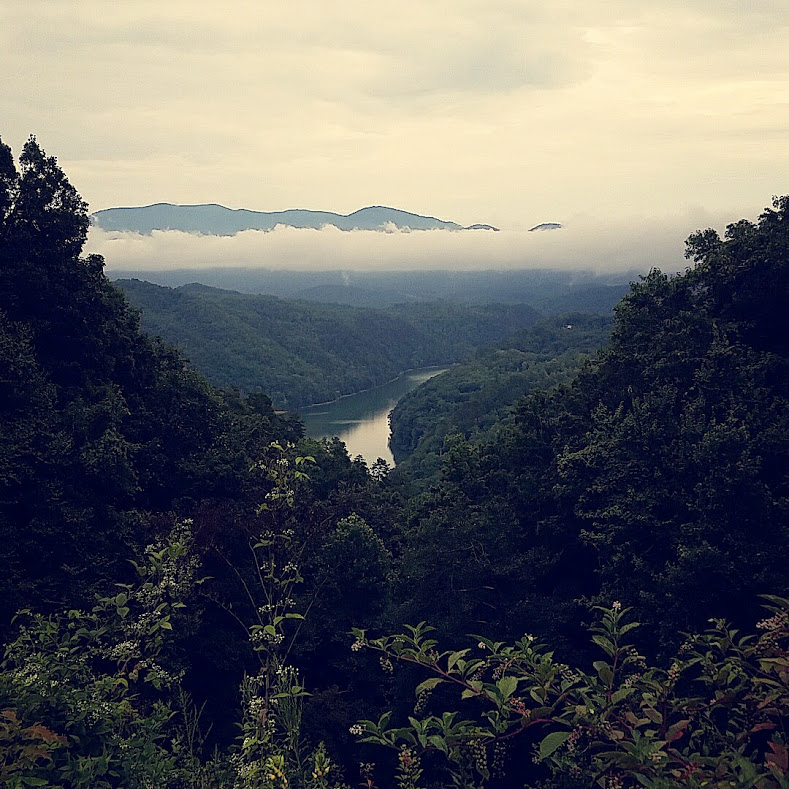
It takes a full week to get the most out of all area roads. We also suggest taking a couple days to explore our Smoky mountain lakes, stream, and trails.
Bring Your Group
From official rallies with hundreds of attendees to a small gathering of friends, our region is ready to host your group. Let us help you plan your event.
Bring Your EV
Find charging station in the area. Tail of the Dragon is a J1772 station, Tesla Destination station, and has a NEMA 14-50 outlet. Click Here to find us on plugshare.
Your Safety and the Law
Ready to navigate the mountains? Tips on what to bring, how to ride and drive, and law enforcement.
Driving directions, GPS coordinates, and street addresses to use.
Websites to Visit
Good list of websites to help you plan your trip. You'll find information on the touring route including points of interest, places to stop, where to stay, and history of the area.
Dragon Photographers
Find your Tail of the Dragon and Moonshiner28 Photos here.
Online Brochure
View and print the current Tail of the Dragon Map Brochure.
QUESTIONS? Reach out to us:
When to visit.
The Tail of the Dragon is Federal Highway US 129 and is free for the public to enjoy at any time. It may be closed at times due to downed trees, rock slides or when the highway is blocked by accidents. For the most part it is open year round. We will post closures on TailoftheDragon.com and Facebook .
The primary season is April through October. March and November can be iffy, especially in the higher elevations of the Cherohala Skyway , Blue Ridge Parkway and US 441 in the Great Smoky Mountains National Park .
CLICK HERE for help planning a Fall Color Tour including leaf reports, photos, videos, maps and more.
Winter months can be cold and snowy, but there are some days warm enough to ride. Cars can have the roads to themselves in the winter. Visit our Weather Page for current conditions and more details. CLICK HERE to view off season accommodations.

WHERE TO STAY
The Tennessee side of the Smokies offers more for families and people interested in night life and other recreational pursuits.
THE GOOD Gatlinburg and Pigeon Forge have hundreds of motels and cabins. There are also many tourist attractions and places to eat. THE BAD Crowds and longer rides to get to the great roads.
The North Carolina side is much more rural if you want to get away from the crowds. We call it the "quiet side of the Smokies".
THE GOOD You are close to the great roads and no crowds. THE BAD A lot less in the way of recreational/dining options.
Reservations are Recommended especially on weekends and holidays.
The Six Gap area of north Georgia is much like the North Carolina area with reasonable lodging rates. If you are on the Blue Ridge Parkway you should plan ahead. There are very few accommodations on this limited access scenic byway.
Plan Your Arrival . The mountains can get dark quickly. We recommend arriving at your primary destination in the daylight. Many of the mountain towns shut down at 9 pm. Plan for dinner before that. Some areas are dry making it necessary to travel for an hour to buy alcoholic beverages. BE AWARE Travel times are much greater on these mountain back roads. In some cases a thirty mile trip might take an hour.
Bring you gear . We highly recommend leathers, gloves, and full face helmets. Temps at 5,000 feet can be 10-15 degrees cooler, so dress accordingly. Visit Motorcycle Rentals & Repairs if you need to purchase gear while you are here. South Carolina is the only state in the region that does not require a helmet.
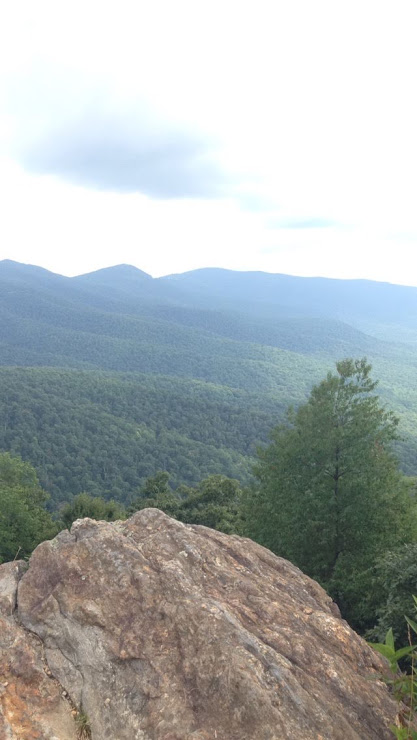
GREAT ROADS
Western North Carolina, North Georgia, and East Tennessee. CLICK HERE for printable map.

HOW LONG TO STAY
It takes a full week to get the most out of all area roads. We also suggest taking a couple days to explore our Smoky mountain lakes, stream, and trails.

Full Day Road Tour
If you are staying near the Tail of the Dragon, these routes can be toured in a full day
• Smoky Mountain Loop • Dragon-Cherohala Loop • North Carolina Loop • North Georgia Ruby Run • Ocoee Loop • North Georgia Six Gap • Devils Triangle TN
Overnight Road Tour
If you are staying near the Tail of the Dragon, plan on an overnight trip for the following routes. Visit our Where to Stay for convenient lodging. You might be able to catch some of these either on your way here or on your way home.
• Snake421 in Shady Valley TN • Diamondback226 Little Switzerland and Blue Ridge Parkway • Gambler NC209 and Hot Springs NC
Gravel Routes
Recommended Forest Service roads for licensed dual sport motorcycles, jeeps, or 4wd.
• Routes in Western North Carolina and Eastern Tennessee • Waucheese Mountain • Tatham Gap aka Gravel Dragon

BRING YOUR GROUP
What kind of groups visit the Dragon? The three largest rallies (500 plus) are the Minis (April), Zdayz (May), and Miatas (August). There are many other nearby rallies in Cherokee and Maggie Valley. Nearby Pigeon Forge in Tennessee hosts several large antique car rallies each year. See EVENTS page for complete list.
If you see an event posted, don't stop from planning a trip. Most of the groups that visit Tail of the Dragon are small, informal gatherings of car or motorcycle groups. The rallies include a wide range of vehicles from MoPeds to supercars.
All of these rallies are planned, organized and conducted by private individuals or groups. TailoftheDragon.com simply acts as a place to list the events and spread the word. We have no specific part in any of the events except to provide a place for attendees to meet.
What can Tail of the Dragon provide for your group? We can post notice of your event to help attract other interested parties. We can make custom group signs, free stickers, and provide use of our graphics for event T-shirts or brochures. We can provide a location for scavenger hunts or poker runs. CONTACT US to make arrangements.
Many of the roads such as the Tail of the Dragon , the US421 Snake , the Cherohala , and Six Gap are patrolled on a regular basis. At times there will be LEO (law enforcement officer) saturation. Smart riders can spot this and ride more cautiously. In North Carolina watch your speed on the 4-lanes, many locals are rescue squad volunteers with radios in their personal vehicles and report speeders and reckless drivers.
Helmets are required in North Carolina, Tennessee and Georgia. Need to purchase gear while you are here? Visit Motorcycle Rentals & Repairs page for locations.
For more information on the area law enforcement visit our Area Law Enforcement Page .
If you need legal help, we recommend the following area attorneys:
• Mack Tallant - Robbinsville Tel 828-479-2442 • Darryl R. Brown - Murphy Tel 828-835-9496

YOUR SAFETY
Are you ready to negotiate the curves? Our number one piece of advice is to STAY IN YOUR LANE and that doesn't mean hugging the double yellow. Before your visit, read our advice found on How to Ride the Dragon and How to Drive the Dragon .
Don't rely on cell phone service in the mountains. Verizon has the best coverage near populated areas.
We recommend carrying a GPS location device such as the SPOT or the Garmin inReach These devices allow you to share your location with family and friends and also gives you an SOS to emergency services, regardless of cell phone service. If riding alone this could save your life. There have been a number of cases where rider/drivers went off the road and were not found for days or even weeks. Many locations here are remote and not heavily traveled. Tell someone each day where you plan to ride. Keep in touch with loved ones so they don't call us in a panic looking for you.
Tail of the Dragon, Moonshiner 28, Cherohala Skyway
• from Asheville, Maggie Valley, Waynesville, Cherokee, and Bryson City NC • from Chattanooga & Clevelend TN • from Nashville & Knoxville, TN • from Atlanta, Gainsville, and North Georgia • from Gatlinburg, TN • Distance to the Dragon from various locations in the US
Devils Triangle TN
• from Tail of the Dragon
ROAD CONSTRUCTION and CLOSURES
• Blue Ridge Parkway Real-time Road Closures • Great Smoky Mountains National Park • Great Smoky Mountains National Park Real-time Twitter Feed • TN-DOT Real-time Map • Western North Carolina Real-time updates
GPS and STREET ADDRESSES
Tail of the Dragon (intersection of US129 & NC28 one mile south of the TN/NC state line) 35.466715,-83.920251 Street address 17555 Tapoco Road, Robbinsville, NC 28771 NOTE: Using street address does not always produce the correct results. Also search for the intersection of US129 and NC28.
Cherohala Skyway 35.345333, -83.89465 (North Carolina) Street address for Cherohala Skyway Visitor's Center in Tellico Plains TN: 225 Cherohala Skyway, Tellico Plains, TN 37385
Moonshiner 28 (intersection of US129 & NC28 one mile south of the TN/NC state line) 35.466715,-83.920251 Use street address 17555 Tapoco Road, Robbinsville, NC 28771 for the northern most post of NC28 NOTE: Using street address does not always produce the correct results. Also search for the intersection of US129 and NC28.
Devils Triangle search for cities: Oliver Springs, TN, or Petros, TN 36.0472, -84.346683
Six Gap North Georgia (north end US129 & GA180) search for Suches, GA 34.77185, -83.914183
Diamondback226 (Blue Ridge Parkwy) search for Little Switzerland, NC 35.8492682,-82.160434
The Gambler NC209 search for Hot Springs, NC 35.6877653,-83.699616
TailoftheDragon.com
The complete website for the number one motorcycle/sports car road in the country.
Moonshiner28.com
105 miles of fun and sightseeing with waterfalls, mountain views and shopping.
Cherohala.com
Mile-high scenic road from Robbinsville North Carolina to Tellico Plains Tennessee.
FoothillsParkwayTN.com
Follow a Smoky Mountain Ridgeline from US129 to Walland, TN. Additional 16 mile extension coming in 2018.
SmokyMountainLoop.com
141 Loop which winds through the Tail of the Dragon, Foothills Parkway, Great Smoky Mountains National Park, and finishing this epic loop with the sobering curves on Moonshiner28.
GamblerNC.com
NC 209 to Hot Springs, NC. Luck, Trust and Bluff your way along this route with some epic twisties near Waynesville, NC. (aka The Rattler)
73 mile long figure eight loop in north Georgia with mountain scenery. Part of the 133 mile long Gauntlet Run.
DevilsTriangleTN.com
Think you’ve seen a switchback? Ride the Triangle and then you’ll know what a real one is. Not for the squeamish or new rider.
Diamondback226.com
Twist your way down from the Blue Ridge Parkway from Little Switzerland.
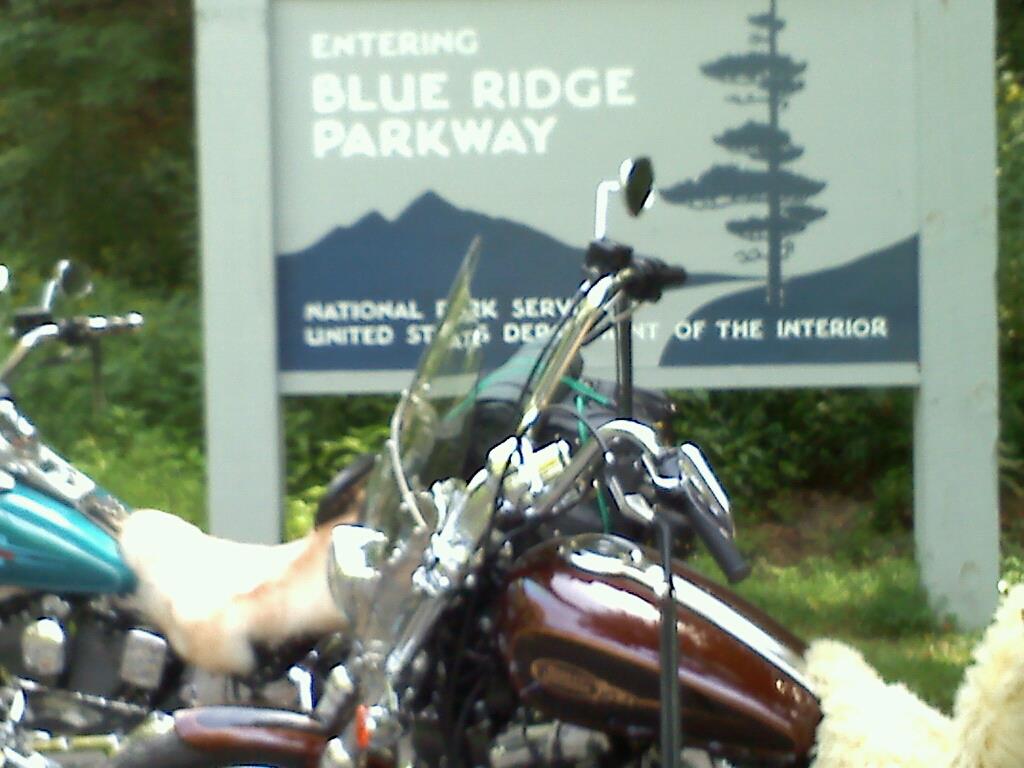
BlueRidgeParkway.org
469 scenic miles from Cherokee, NC to the Shenandoah National Park in VA.
ClawoftheDragon.com
Southwest Virginia mountain roads including the Back of the Dragon
TailoftheDragonMaps.com
Printable regional maps for your trip.
TailoftheDragonResorts.com
Find a place to stay in the region you want to visit.
TailoftheDragonTours.com
Browse touring routes by region.
GrahamChamber.com
Graham County North Carolina tourism website. This area is centrally located to all the great roads.
Motorcycle Rentals Repairs Recovery
Recommended motorcycle rentals, repair service, and vehicle recover service.
Other Things To Do
The region surrounding the Tail of the Dragon is home to class 4 whitewater, pristine trout streams, mountain top trails, and crystal clear lakes. Take in our mountain culture and visit our local artisan studios and farm-to-table restaurants. Extend your trip an extra day or two and explore!!
How to Tame the Tail of the Dragon: Your Guide to Riding US-129
“The Tail of the Dragon” road in the Smokies is as legendary as the dragon itself. By now, you’ve either heard it’s one of the most dangerous roads in America, or it’s one of the most stunning drives in the Smokies.
The truth is that it’s a little bit of both, and you don’t have 100% control of how safe you’ll be driving it. At the same time, statements like that create a buzz that makes even more people want to slay this dragon.
Spoiler Alert–we aren’t going to tell you how to beat the record time on this twisty road with more than 300 curves along 11 miles. We’re more about sightseeing than countersteering.
We will share with you the tips and tricks to enjoy this road safely during the best times of the day and year and where to stop nearby to share in the glory of conquering the Tail of the Dragon.

Where is Tail of the Dragon?
Better known as U.S. Route 129, Tail of the Dragon is an 11-mile ribbon of roadway that winds through Deals Gap across the North Carolina/Tennessee border. Less than a mile is in North Carolina, and the rest are in Tennessee
U.S. Route 129 rides the far southwest corner of Great Smoky Mountains National Park . Two cities bookend Tail of the Dragon–Robbinsville in North Carolina and Mayville in Tennessee.
One of the main access points is along North Carolina Highway 28, which carves through the Nantahala National Forest on scenic journeys of its own.
The Indian Lakes Scenic Byway spans 32 miles to Almond, including the Cherahola Skyway.
Twenty miles later, Highway 28 turns into the Waterfall Byway , running another 20 miles almost to the South Carolina state line.
While those are the official byway names, the route on Highway 28 is now known as the Moonshiner 28 among motorcycle and sports car fans.
How to Get to Tail of the Dragon
The south end of Highway 129 is about 50 miles from Cherokee, North Carolina . You’ll cover the Indian Lakes Scenic Byway on the way there. From Gatlinburg , you’re looking at a different 50-mile drive on the Foothills Parkway through Happy Valley.
It’s worth noting that even if you want to get to the other side of the Tail of the Dragon, you’ll need to take the road unless you want a 100+ mile detour.
If you need waypoints for Google Maps, select Dragon City in Maryville and Trail of the Dragon souvenir store in North Carolina.
Parson Branch Road
Here’s a well-kept secret entrance to the Tail of the Dragon from Great Smoky Mountains National Park. Parson Branch Road is only for the most adventurous drives with a four-wheel drive, high-clearance vehicle, and it has been closed for years, just opening again in May 2022.
From the Cable Mill Historic Area and Visitor Center at Cades Cove , follow the signs for Forge Creek/Parson Branch Road. After two miles, turn on Parson Branch Road. This is a one-way street, and you’ll navigate several streams on the way.
Parson Branch Road is closed during the winter, from December through March. When it is open, you will enter Tail of the Dragon somewhere in the middle.

Trail of the Dragon History
A rudimentary trail offered access for the native Cherokee for centuries. Settlers used the trail in the 1700s. The British worked through this treacherous area to establish Fort Louden . During the Trail of Tears in 1831, Cherokee familiar with this route used it to escape the forced abandonment of their homeland.
The road then became the access to Parsons Branch, where settlements were established before the creation of the national park.
Up until the late part of the 20th Century, only people who lived here or lost visitors traveled this curved road. Over time, those who loved the challenge of navigating curvy roads by motorcycle or sports cars started to take notice of Route 129.
Local motorcycle rider Doug Snavely put the route on the map for the general population, much to the dismay of the locals. Angry that the secret was out, Snavely was threatened and shot once on his way to let other riders know about this epic route.
Since then, the Tail of the Dragon has become globally famous, ranked as one of the best drivers and most dangerous routes in the world.

What Makes Tail of the Dragon So Popular?
I don’t pretend to be a motorcycle rider, and my Suburu climbs mountains better than it handles hairpin turns, but it’s the epitome of a tough ride to challenge even the most experienced riders.
The road has 314 curves–some down to a suggested 10-mile-per-hour speed limit–across just 11 miles with minimal interference from cars entering the road. The road demands precision, control, and agility, providing a thrilling test of skill. Add in the road’s elevation changes and hairpin bends, and the Dragon is a dynamic and immersive driving experience unlike any other.
On top of that, the Tail of the Dragon has developed a vibrant community of motorcyclists, sports car enthusiasts, and automotive aficionados who come together to share their passion for driving and riding. This sense of camaraderie and shared enthusiasm adds to the appeal of the road.
Here are some places to visit if you want to meet up with the groups:
- Deal’s Gap Motorcycle Resort
- Dragon City Resort
- The Dragon 3:18
Look for the Tree of Shame, which is decorated with broken motorcycle parts for those who didn’t come out of the dragon’s lair unscathed.

Is Tail of the Dragon Really That Dangerous?
The biggest tale about the Tail of the Dragon is that it’s statistically ranked as one of the most dangerous roads in North Carolina/Tennessee/America/Earth, etc. It has the potential to be very dangerous or among the most dangerous. Most of the risks are less about the road and more about the decisions drivers make.
On average, about three people die each year on the roadway, and between 2021 and 2022, 17 accidents were reported. A dozen of those were motorcycle accidents. As the road became more popular with sports car drivers and motorcyclists, the intensity of rides increased.
Keep in mind this is a road with a 30-mile-per-hour speed limit with turns that usually average a speed limit of 15-20 miles per hour. We watched various YouTube videos where motorcyclists were trying to race the Dragon with speeds in excess of 100 miles per hour, taking turns at 45-55 miles per hour. That is what makes this road dangerous for everyone.
If you’re sticking to the speed limit, staying in your lane, letting faster vehicles pass, and not getting distracted by the views, it’s as safe as any other road when the weather is clear. Every road becomes exponentially more dangerous with rain, snow, or ice on it.
Safety Guidance on Tail of the Dragon
You shouldn’t let the “dangerous” aspect of the road scare you away. In fact, more riders are heading to the Cherahola Skyway, and that’s one of the best drives in the Smokies .
Between best practices and road etiquette, you can enjoy the Tail of the Dragon.
Speed is one of the biggest reasons for accidents on the Tail of the Dragon. That goes as much for your vehicle as being prepared for speeding vehicles coming around the next corner.
If a vehicle going faster than you is approaching, do not be stubborn and keep going slow while allowing them to tailgate you. Also, avoid hitting the gas to match their speed. Simply pull over at the next road pull-out and allow them to pass.
Semi-trucks aren’t allowed on this highway, but they still use it from time to time and will take up much of the road while negotiating turns. Give them space. Salty looks are okay, too. Don’t attempt to bring a truck or trailer longer than 30 feet up this road.
Avoid the Tail of the Dragon on weekends, especially when the weather is nice, between 10am and 6pm. A mid-week 9am drive should be more pleasant than anxiety-inducing. Check road conditions before you head out, and use extra caution or avoid it altogether in winter.
What’s Near Tail of the Dragon?
Head two miles south of the souvenir store to see Chenoah Dam, otherwise known as Fugitive Dam. It’s where Harrison Ford jumped after being cornered by Tommy Lee Jones in the 1993 movie The Fugitive. In fact, the train crash scene from the movie is still just outside Dillsboro, about 60 miles from the dam.
On the way back to Cherokee, stop at Fontana Dam, an engineering marvel built during World War 2. Fontana Village offers shops and dining to explore, plus you can also catch up with the Appalachian Trail at Fontana Dam.

Tame the Dragon and Other Scenic Routes
You don’t need to avoid any of these roads, as they offer some of the best views across the Smokies and Blue Ridge Mountains. Be smart and safe. If you aren’t a motorcyclist, you might want to skip a trip during the Smoky Mountain Bike Week or Thunder in the Valley (and other large bike events) that could put more people trying to slay the Dragon.
If the risks don’t motivate you to drive safer, the regular police patrols might. With the number of deaths and accidents, plus the risks rescuers take, you likely won’t get off with a warning.
As an avid road tripper, one of my favorite things to do is drive with a buddy. We take the road twice, so each of us gets a turn driving and the other sightseeing.
Similar Posts

20 Best Fall Things to Do in the Smoky Mountains
Looking for the BEST fall things to do in the Smoky Mountains? Use our carefully curated list to start planning your Smoky Mountain fall…

Don’t Miss Smoky Mountains Super Blue Moon | Aug. 30, 2023
In 2023, we are experiencing a remarkable year for supermoons here in the Smoky Mountains with four incredible events gracing our night skies. We…

50+ Smoky Mountain Words & Phrases: An Applachian English Dictionary
Traveling to the Smokies? Before you visit, prep yourself by learning some of the most common Smoky Mountain words and Applachian English phrases. Also,…

10 Smoky Mountain Views That Will Take Your Breath Away
Now that spring is here you might want to take advantage of the great weather and take on Smoky Mountain’s many popular hiking trails….

Book an Unforgettable Railway Experience on the Great Smoky Mountain Railroad
Great Smoky Mountains National Park is a wonderous place that’s perfect for having one-of-a-kind adventures. But across the national park from Gatlinburg awaits adventures…
![7 of the Best Smoky Mountain Hiking Trails [Easy to Moderate]](https://www.wanderingsmokymountains.com/wp-content/uploads/2022/05/Charles-Bunion-400x267.png "tail of the dragon trip")
7 of the Best Smoky Mountain Hiking Trails [Easy to Moderate]
With numerous Smoky Mountain hiking trails to choose from, which ones provide the best Smoky Mountain hikes? These 7 Smoky Mountain trails are perfect…
Roadstotravel
Find the best roads, tail of the dragon: the ultimate road trip.

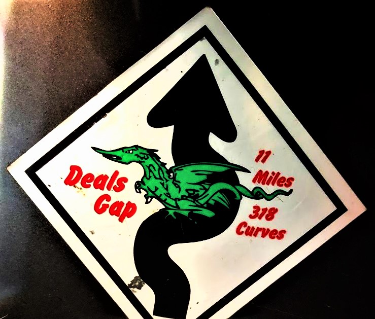
The Tail of the Dragon, a stretch of US 129 situated at the junction of Tennessee and North Carolina, is known for its 318 curves and its location within the Great Smoky Mountain National Forest and the Cherokee National Forest. It’s a popular destination for motorcyclists, sports car enthusiasts, and photographers.
Where is the Tail of the Dragon?
It begins in North Carolina and ends in Tennessee. It winds around the southern border of the Great Smoky Mountains National Park. The road is close to the Blue Ridge Parkway making it an ideal addition if you like scenic road trips.
The road and its typical Appalachian landscapes are magnificent, especially as no construction pollutes the route, still, people come here mainly to test their driving skills and experience the rare satisfaction of doing turns.
You can locate the Tail of the Dragon road on the map below:
Facts about the Tail of the Dragon
Deals gap road description:.
In North America, few roads have the reputation of Route 129. With 318 turns over a distance of 18 kilometers (11 miles) situated into the mountainside, this road puts drivers to the test because of the complexity of the route.
The road is a two-line highway that crosses the Deals Gap at 605 meters (1,990 ft) above sea level. It will take you approximately 30 minutes to drive that road.
Twisting through the middle of the forest, it is made up of 318 bends over a distance of 18 kilometers (11.2 miles), all on the mountainside. Bikers consider is as their number 1 destination! Intended for experienced drivers, it will give you curve after curve, uphill, downhill, a good adrenaline rush. That’s why you sometimes read in the local news: Tail of the Dragon crashes.
The Tail of the Dragon road is notorious for its tight bends, making it a hazardous driving experience. The “Tree of Shame”, is a reminder of the dangers. It is being decorated with pieces of damaged motorcycles. Despite the dangers, the Tail of the Dragon is a unique and popular route that has even attracted the attention of film producers.

Why is it called Tail of the Dragon?
The Tail of the Dragon road got its name from its tortuous path resembling a dragon’s tail.
The route is also named the Deals Gaps. There are many twists and turns, and the road is one of the best drives in the United States, along with scenic routes such as the Ortega Highway , the Million Dollar Highway or the Cherohala Skyway .
When was Deals Gaps road built?
The Tail of the Dragon road has existed since the early 1900s. Initially, it was a gravel road, but it was paved with asphalt in the 1920s. This improved the overall driving experience, making it smoother and safer for travelers.
Since then, the road became famous among the bikers who love riding there.
On the road, you will find a gift shop. Also, there is a hotel along the Tail of the Dragon with a restaurant called the Deals Gap motorcycle resort.
You can obviously find other accommodations such as motels, cabins, and camping nearby the Tail of the Dragon.
The bikers gave names to the turns like Copperhead Corner, Hog Pen Bend, Wheelie Hell, Shade Tree Corner, Mud Corner, Sunset Corner, Gravity Cavity, Beginner’s End, and Brake or Bust Bend.
For both bikers and drivers, the Tail of the Dragon road is a legendary and highly desired destination. As a mark of accomplishment, many people want to have their sticker placed on the Tail of the Dragon road sign.
Where is the Tail of the Dragon located?
To experience the Tail of the Dragon, one must take the journey on Road 129, which runs alongside the Blue Ridge Parkway.
If you are coming from the North from Knoxville, for example, drive directly to road 129. And, if you are coming from the south, you have to drive road 28 or 129 until you reach the Deals Gap motorcycle resort where the road starts.
You can visualize how to get there on this Deals Gap Tail of The Dragon map of the drive:
A preview of this scenic Deal Gap road:
The popularity of this road is increasing and it making it more and more difficult to drive as it becomes overcrowded. Accidents are a common occurrence as many drive at speeds well above their actual capacity. Fortunately, the road does not allow very high speeds, and fatal accidents are rare. Additionally, a tree near Deals Gap, known as the “Tree of Shame”, displays parts of vehicles that have crashed on the Tail of the Dragon road as a reminder of the dangers of reckless driving.
If you are planning to drive the Tail of the Dragon road, you can watch this YouTube video:
Is the Tail of the Dragon road Open?
The Deals Gap road is generally open all year round, although in the winter the weather in this zone is harsh and very unpredictable. Indeed, the weather can change rapidly, and a sunny day can quickly turn into heavy snowfall.
The only benefit of driving during the winter on the Tail of the Dragon is the capacity to see through many of the corners. Indeed, because the trees have lost their leaves. There is a better visibility from November through March.
Please note that the National Park Service closes the road after heavy rain or thunderstorms. Watch out for animals that may cross the road. Indeed, you might meet bears, deer, and wild boars.
We advise you to avoid the high season or the weekend if you want to enjoy your ride and not be in a traffic jam! If you can’t come here in the low season, come early!
Please note that the speed limit on the road was 90 km/h (55 mph) prior to 1992. It was reduced to 50 km/h (30 mph) in 2005 after numerous accidents, and police often perform speed checks. In fact, 37 persons died on that road from 2000 to 2017.
If you are looking for one of the best drives in the USA, the Tail of the Dragon is definitely a must-do! Although, you should respect the speed limit and be very careful: many bikers consider that the Deals Gap road is a racetrack and can cause accidents.
Pictures sources: CC BY 2.5, https://en.wikipedia.org/w/index.php?curid=6975930 / By Washuotaku – Own work, CC BY-SA 4.0, https://commons.wikimedia.org/w/index.php?curid=34143695
Discover other roads around the United States: click here or see our road map!
Related posts:

- Lodging Discounts
- Pigeon Forge
A Motorcyclist’s Guide to Tail of the Dragon and Other Smoky Mountain Drives
While there are a ton of great drives for motorcycle riders in the Smokies, the Tail of the Dragon is the one that reigns supreme! Between the amazing scenery and the breathtaking curves, it is on the bucket list for most motorcycle enthusiasts. Here is a complete motorcyclist’s guide to the Tail of the Dragon and other great Smoky Mountain drives:
Brief History of the Tail of the Dragon
The 11-mile route has a deep history that dates back centuries ago. While it is most known today for its thrilling ride, that was not always the case. Back in the early 1700s, the Cherokee Indians and early European settlers used this area as prime hunting ground. However, the Indians were forced off the land with the Indian Removal Act of 1830. Then, in 1934 the road was paved so it could start being used for travel. The amazing part about the road is that it took nearly 60 years for it to gain popularity among motorcycle riders. It wasn’t until the 1990s that the road became the known entity it is today.
Details About the Drive

While this is one of the most popular drives for all motorcycle riders, there are still some interesting facts that you might not have heard about this famous road. Did you know that there are a total of 318 curves over the 11-mile stretch? Also, there are no intersecting roads or driveways to hamper your travel. Another interesting fact is that the road is bordered by both the Great Smoky Mountains and the Cherokee National Forest!
Other Smoky Mountain Drives for Motorcyclists
While the Tail of the Dragon is known as the supreme ride among motorcyclists, there are many other great drives that offer amazing benefits. Here are just a few of other drives in the Smoky Mountains that are worth taking:
Newfound Gap Road

Foothills Parkway
The Foothills Parkway consists of 33 miles and connects US 129 and US 321. This is one of the best scenic drives you can take in the Smoky Mountains. There are numerous pull off spots that make this drive unforgettable. While the views are amazing during all times of year, it has become a popular scenic route during fall because of the spectacular sights of fall foliage. If you have just got done driving the Tail of the Dragon, the Foothills Parkway provides an easy connection to Pigeon Forge and Gatlinburg!

Now that you have a guide to some of the best Smoky Mountain drives for motorcyclists, including the Tail of the Dragon, be sure to check out some of the other fun things to do in the area. We hope to see you soon in the Smokies!
Related Posts

Exciting Improvements Coming to Newfound Gap Road Near Gatlinburg

5 Amenities to Splurge on in Our Smoky Mountain Cabins

5 Smoky Mountain Adventures to Try at Least Once

Your Guide to Mount LeConte in the Smoky Mountains

The Travelberry

The Tail of the Dragon – A Smoky Mountain Road Trip
On this page, trip snapshot, how we got around, where we stayed, what we did.
To take on the infamous Smoky Mountain drive, the Tail of the Dragon, located at the Deals Gap mountain pass near the North Carolina-Tennessee state line.
When We Went
August 2015
Length of time
We spent 4 days driving through the Smoky Mountains.
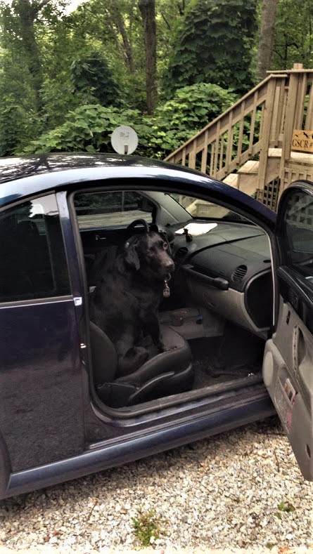
Dog-Friendly Trip
Our black lab, Bocephus, came along with us.
Here’s a visual of where we were on this trip:
Back to Top
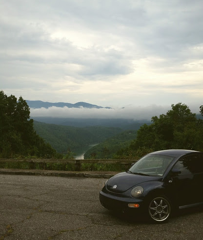
This was our first road trip together through the North Carolina mountains in Alex’s old Volkswagen beetle.
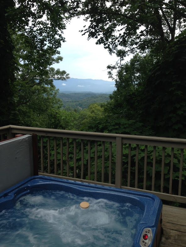
A Cabin in Bryson City
We rented an adorable cabin Alex found online. It was located in Bryson City, a charming mountain town .
The view from the back deck:
Did I mention there was a hot tub?
- Hiking in the Great Smoky Mountains
Fontana Dam
The road to nowhere, the tail of the dragon, hiking in the smoky mountains.
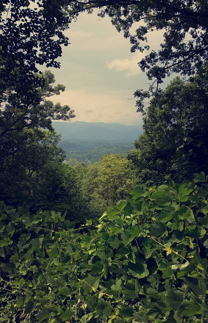
Before we took on the legendary drive, we spent a couple of days hiking.
There seemed to be a constant haze in the sky, it’s easy to see how the mountains got t heir name.
Numerous hiking trails can be found throughout the area.
Most hikes we did were fairly moderate. A quick Google search will hook you up with one – and maybe even a waterfall.
Back to What We Did
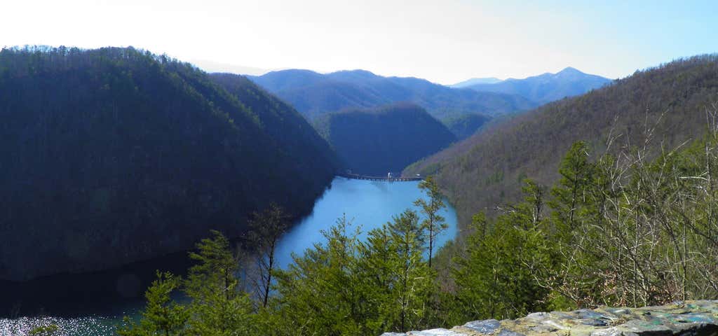
We stopped to check out the Fontana Dam .
At a whopping 480 feet high, it’s the tallest dam in the Eastern United States.
There is a parking area where you can get out and walk across the dam.
Fontana Lake is a reservoir impounded by the dam and is a great area to go exploring as well.
When the Fontana Dam was built, they tore down highway 288. The federal government had planned to replace the highway with a new road, but an environmental issue halted its construction. It was left as is, completely unfinished.
The partially built road now ends, quite abruptly, at a tunnel.
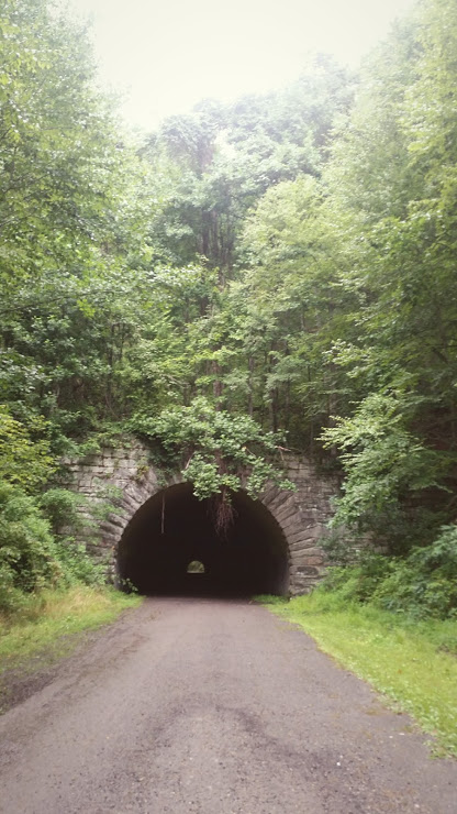
You can walk through the tunnel and see for yourself how it just kind of stops, it really is The Road to Nowhere .
On our last day in the mountains, we were ready to take on the drive.
The Tail of the Dragon is a stretch of US 129 that packs in a staggering 318 curves in just 11 miles. It is located at the Deals Gap mountain pass along the North Carolina–Tennessee border.
As we made our way down and rounded bend after bend in the road, it was clear how the treacherous track appeals to enthusiasts from all over the world.
Motorcyclists would fly around the turns at an easy 45 degree angle, with nothing to prevent them from spinning out and tumbling down the side of the mountain. Nothing. There are no guard rails.
Finally, after swerving around a hundred more times or so, we came to the end of the tail. We weren’t done yet, now we had to turn around and go back the way we came, back through the 11 miles of twists and turns.
Now, I’m not one to get motion sick, but not long into my second go around the dragon tail and my stomach started to revolt. I had to tell Alex he was either going to have to take it easy, or deal with me getting sick all over the passenger seat.
I peeked in the back seat, Bocephus was doing great, smiling as big as ever, tail wagging. He’s a much better rider than I am!
Somehow I managed to hold down my lunch and we successfully conquered the Tail of the Dragon.
What did we get for accomplishing such a feat?
Nothing, but we did pick up this sticker at the gift shop.
- Already have a WordPress.com account? Log in now.
- Subscribe Subscribed
- Copy shortlink
- Report this content
- View post in Reader
- Manage subscriptions
- Collapse this bar
- © Roadtrippers
- © Mapbox
- © OpenStreetMap
- Improve this map
Tail of the Dragon: US 129's windy scenic drive
Do you have the guts to tackle the 318 hairpin turns along this drive?
- Featured Trip Guides
Created by angela.przybranowski - May 20th 2016
Twists, turns, and thick woods: this drive isn’t about scenic overlooks and nature’s majesty, the way a drive through Arches National Park or down the Loneliest Highway are. The Tail of the Dragon is about you, the pavement, and two white knuckles holding tightly to a steering wheel. That’s why this stretch of road is considered one of the most exciting drives in America. Cutting through the mountains in Deals Gap at the Tennessee/North Carolina state line, the Tail of the Dragon is actually just a portion of the longer US 129, or as some North Carolina folks call it, “that damn road to Tennessee”.

Robbinsville, NC, US
The legend of the Tail of the Dragon has spread far beyond North Carolina and Tennessee, and has even caught the eye of movie producers, celebrities, and documentary crews. The road and nearby Cheoah Dam were featured in “The Fugitive,” and parts of the gearhead classic “Two-Lane Blacktop” actually feature much of the road at the very end of the movie.

17548 Tapoco Rd, Robbinsville, NC, US
Deals Gap Motorcycle Resort
Click to discover a great deal!
Whether you’re starting or completing the Tail of the Dragon at the intersection of US 129 & NC 28, Deals Gap Motorcycle Resort in Robbinsville, NC is the perfect place to snap pictures, grab souvenirs, eat lunch, have a cold beer, or even spend the night.

17555 Tapoco Rd., Robbinsville, NC, US
Tail of the Dragon Store
Also check out the Tail of the Dragon Store across the street for more great souvenirs, and your obligatory photo with the giant eponymous Dragon sculpture.

US 129, Tallassee, TN, US
Calderwood Overlook
Next, pull over at the Calderwood Overlook. This beautiful scenic overlook just off the Tail of the Dragon offers a gorgeous view of the Cheoah Dam. Also, it's a fantastic view of the Smoky Mountains and Tennessee countryside, particularly in the fall, when the leaves change color, or in the summer when everything is lush and green.
Of course, a stretch of road this famous has a legend or two surrounding it. For instance, travelers of the Dragon claim they’ve heard more than one ghost while on the road at night. With the stretch having claimed the lives of many over the years (on average, the 11-mile Tail of the Dragon takes at least one life a year), it’s natural to assume the road just has to be haunted. Death and bloodshed, however, also came to the area long before the paved road cut through Deal’s Gap. The Cherokee fought more than one battle in the area, it’s reported there’s at least one Civil War soldier buried near the road, and rumors of an angry land owner hanging motorists who wouldn’t pay his toll also figure into the lore of the Dragon being haunted.
Need an excuse to drive the Tail of the Dragon? First of all, it’s surrounded by other slightly-less-curvy, but still exciting and scenic roads, and the Dragon can easily be worked into a scenic route toward Asheville, one of the most beautiful towns in the Carolinas. Don't try to attempt the Dragon in winter, as these 318 turns can be quite treacherous in snowy and icy winter weather conditions. Also, try to avoid it during the rainy spring season. It gets pretty busy in summer and fall but those times are when weather conditions are ideal for cruising down this epic road.
angela.przybranowski
Keep exploring with the roadtrippers mobile apps..
Anything you plan or save automagically syncs with the apps, ready for you to hit the road!
Connect with us and hit up #roadtrippers
Tall tales, trip guides, & the world's weird & wonderful.
- Roadpass Digital
- Mobile Apps
Business Tools
- Partnerships
Get Inspired
- Road trip ideas by state
- National parks
- Famous routes
- Voices from the Road
Fresh Guides
- The ultimate guide to Mammoth Cave National Park
- The Ultimate Guide to Badlands National Park
- Route 66 Leg 2: St. Louis to Tulsa
- Route 66 Leg 1: Chicago to St. Louis
- Route 66 Leg 3: Tulsa to Amarillo
- Top 10 things to do in Ohio
- Offbeat Road Trip Guides
- Road Trip USA
- Scenic Routes America
- National Park Road Trips
- Terms and Conditions
Riding the Tail of the Dragon? Here’s 7 More Things to Do on This Road Trip

If you’re a motorcyclist or sports car enthusiast, get ready to pack your bags and take a road trip to Deals Gap, North Carolina. Nestled within the Great Smoky Mountains of the North Carolina and Tennessee border is an exciting, curvy mountain road called Tail of the Dragon.
For many years, this thrill ride was unknown to the world. However, everything changed in the 2000s when Tail of the Dragon was featured in several movies and TV shows. So, if you’re looking for the ultimate road trip, consider adding Deals Gap, North Carolina, to your bucket list of destinations. Bonus, this destination is within one day’s drive for more than 50% of Americans .
Where Is Deals Gap, North Carolina?
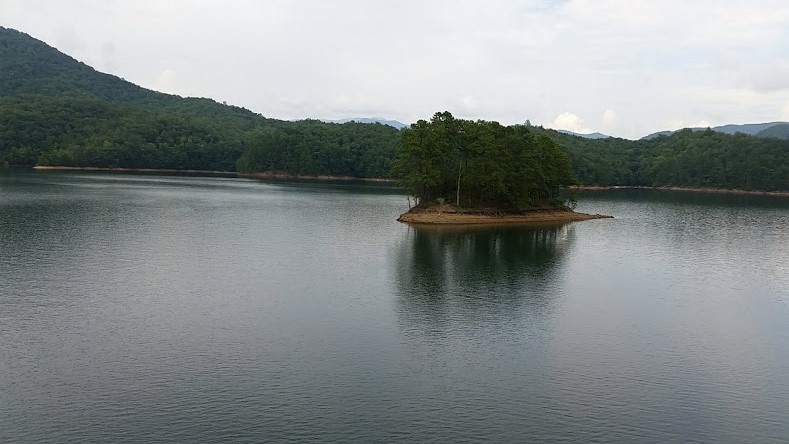
Located in western North Carolina , Deals Gap is a small but charming town situated on the edge of the scenic Cherokee National Forest. Set on the shores of beautiful Fontana Lake, this picturesque mountain community serves as a popular recreational destination for outdoor enthusiasts and road-trippers.
Deals Gap is approximately four hours from Charlotte, NC, an hour and a half from Knoxville, TN , and two and a half hours from Chattanooga, TN.
Whether you’re interested in rock climbing, hiking, or fishing, Deals Gap is the perfect place to explore the natural beauty of the southern Appalachians. But what sets this town apart is its fame as “the Dragon,” home to one of America’s most thrilling stretches of highway.
A Thrilling 11-Mile Curve-filled Road
Tail of the Dragon is a stretch of highway that offers an exhilarating ride in the mountains as it weaves through rugged terrain. With 318 curves and over 100 points where drivers can exceed 30 miles per hour, this winding roadway offers an exhilarating riding and driving experience like no other.
Navigating the Tail of the Dragon demands extreme focus and concentration, as drivers must constantly adjust their speed to account for both the curves in the road and traffic on the roadside. Nevertheless, thousands of drivers flock here yearly to drive this legendary stretch of asphalt, eager to tackle its twisting turns and soak up its breathtaking views.
Deals Gap Motorcycle Resort
Deals Gap Motorcycle Resort is a family-owned and operated business that has welcomed riders worldwide for more than 30 years. The resort is situated on 129 acres of land in the mountains of North Carolina and offers tons of accommodations to motorcyclists. Riders can choose to stay in the lodge, cabins, or RV park, and campsites are available too.
In addition to its scenic location, the resort features amenities that make it a perfect destination for motorcycle enthusiasts. There are bike wash stations, a full-service repair shop, and a wide range of riding gear available for rent or purchase.
Things To Do Near Tail of The Dragon
1. great smoky mountains national park.
The Great Smoky Mountains National Park is a must-visit destination for anyone who loves the outdoors. From deep valleys to steep mountainsides, this stunning landscape offers a wealth of hiking trails that reveal its unique beauty from every angle.
One of the highlights of a visit to the Great Smoky Mountains is the opportunity to see a wide variety of plant and animal life in their natural habitats. You will find stunning waterfalls, towering forests, and rushing rivers filled with trout. Whether you are interested in hiking, camping, fishing, or simply taking in spectacular views, this vast national park offers an unforgettable outdoor adventure.
2. Cherohala Skyway
If you’re looking for a fun ride, take a day trip to Cherohala Skyway! This mountainous scenic highway traverses the eastern Tennessee and western North Carolina. It’s a popular tourist destination with sweeping views and gorgeous natural beauty. The Cherokee and Nantahala national forests border the highway on both sides.
3. Calderwood Lake
Calderwood Lake is a beautiful and popular state park in Tennessee, known for its scenic views and recreational opportunities. Surrounded by rolling hills and dense forests, the lake provides excellent habitat for numerous species of plants and animals.
Whether looking for a quiet place to go fishing or a rugged spot for hiking and camping, Calderwood Lake is great for getting outdoors. Boats can be rented by the hour or day, allowing you to explore the lake’s expansive waters. In addition, you can swim and sunbathe on one of the beautiful beaches in the park. If you’re looking for an outdoor adventure in TN, Calderwood Lake is a must-visit destination!
4. White Water Rafting
Deals Gap, North Carolina, is ideal for white water rafting and kayaking. Positioned in between two mountain ranges, Deals Gap has many rivers and creeks perfect for those looking to escape the hustle and bustle of everyday life with a thrilling adventure on the water.
The rapids are never too intense, making Dealing Gap an excellent place for experienced rafters and those looking to try something new. With well-maintained facilities that provide everything you need for an epic day on the river, Deals Gap is ideal for anyone looking for an unforgettable outdoor experience.
Located near the border between North Carolina and Tennessee , the scenic town of Deals Gap is a fantastic fishing spot. With its pristine lakes and abundant rivers, Deals Gap is a mecca for anglers from all over the country.
Whether you’re after trout, bass, or salmon, you’re sure to mage a great catch here. What’s more, many of the area’s fishing hot spots are just minutes from the town itself, making it easy to explore this beautiful landscape and spend a day catching some of nature’s finest offerings.
6. Fontana Dam
Want to explore some more incredible sights? A trip to the Fontana Dam is in order. Less than twenty minutes from Deals Gap, this iconic dam is one of its tallest and most impressive structures.
The dam is designed to support hydroelectric power generation, spans more than 4,700 feet across the Little Tennessee River, and stands at an incredible 480 feet tall. And, if you’re looking for a great place to do a little fishing, about 10 minutes further, you’ll find the gorgeous Fontana Lake.
7. Cheoah Dam
The Cheoah Dam straddles the Little Tennessee River and spans nearly 1000 feet. The dam is impressively tall, with a height of more than one hundred feet, and features an elegant arch design that allows it to withstand even the most powerful currents. As you wander along the dam’s perimeter, you’ll be amazed at its sheer size and incredible power.
So, Will You Go For a Ride on The Tail of The Dragon?
Tail of the Dragon is one of the most popular driving routes in the country, and for good reason. This winding road passes through some of the most beautiful scenery in two states.
No matter how much road experience you have, it’s vital to stay safe when snaking your way along Tail of the Dragon. Keep your speed in check, and be extra cautious around blind turns.
Also, stay alert for wildlife and other vehicles, and always wear proper protective gear such as a helmet and maybe shin and elbow pads too. When approached safely, Tail of the Dragon promises an exciting driving adventure everyone can enjoy.
Featuring sweeping vistas and a winding path that snakes along the TN/NC border, this iconic road trip offers hair-raising twists and turns to delight even the most experienced drivers. So if you’re looking for an adrenaline-fueled ride that will leave you wanting more, head down to the Tail of the Dragon and take on this incredible stretch of road!
This article originally appeared on Wealth of Geeks .

Similar Posts

This Mom Has Traveled to Hawaii 35 Times. Here’s Her Best Family Trip Advice

The World’s 30 Most Difficult Golf Courses

20 Cheap Travel Destinations Across America For Fun-Filled Vacations

A Local’s Ultimate Guide to Visiting Vancouver Island, Canada in 2022

15 Fun Things to Do & Reasons to Visit Yorktown Beach (Outside Williamsburg, VA)

Hilton Hawaiian Village Fireworks: A Beloved Waikiki Beach Resort’s Free 10 Minute Show

Tail of the Dragon Scenic Highway

- Robbinsville
- Things to Do
- Restaurants
- Vacation Rentals
- Travel Stories
- Rental Cars
- Add a Place
- Travel Forum
- Travelers' Choice
- Help Center
Bucket list road - Tail of the Dragon
- United States
- North Carolina (NC)
- North Carolina Mountains
- Robbinsville
- Robbinsville - Things to Do
- Tail of the Dragon
As a FYI ... According to killboy at killboy.com (the original photographer on Tail of the Dragon... read more
Did the road on a motorcycle (i was the passenger) and it certainly lived up to its name. Tons of... read more
Bucket list road
A bucket list road as a motorcyclist or car enthusiast. We were lucky enough to ride the road on a Monday, when the weather was overcast which made for a lot less traffic on the road. I would recommend going throughout the week as it is a very challenging road with sharp turns which would be hard to navigate if it were very busy. It had beautiful scenery and offered a fun ride.

The Tail of the Dragon is must. it was in my bucket list of things to do. We had a fantastic time Unfortunately my Harley days have passed me by due to health issues. Still riding though

Please be aware that 129 is in horrible shape this year(2023). I wrecked my motorcycle due to the condition of the asphalt. The asphalt is coming out of the pavement leaving just the tiny pebbles protruding. This made my front tire lose traction and sent me to the ditch. Luckily I sustained minimal injuries and was able to ride my motorcycle back home after taping the damaged pieces. Thank you to the gentleman at the dragon store for your kindness in helping me! So far I am about 8000 dollars poorer because of this incident. I am not the only one that this has happened to this year. I have heard of others with the same complaint. I went there in 2018 and thoroughly enjoyed the trip!
It was the experience of a lifetime. The weather was perfect. For sure a challenging 11 miles . It could not be a more beautiful trip !

What an experience ! Husband wanted to drive it for his birthday and it didn't disappoint. Lots of fun on a beautiful day.

The Tail Of The Dragon is a beautiful ride on a Motorcycle... As usual, you can't get away from the IDIOTS on those Jap built crotch rocket's that think they need to try to set world speed records on a road that has the speed limit of about 35 - 40 mph... Outside of that, it's a GREAT ride...
BLUE RIDGE PARKWAY AND TAIL OF THE DRAGON RIDE
GAS IS AVAILABLE OFF THE PARKWAY AT ANY OF THESE US OR STATE HIGHWAY INTERSECTIONS…
Virginia US 250 – MP 0 US 60 – MP 45.6 VA 130 – MP 61.6 US 501 – MP 63.9 US 460 – MP 106 VA 24 – MP 112.2 US 220 – MP 121.4 US 58 – MP 177.7 US 52 – MP 199.4 VA 89 – MP 215.8 North Carolina US 21 – MP 229.7 NC 18 – MP 248.1 NC 16 – MP 261.2 US 321 – MP 291.9 NC 181 – MP 312 NC 226 – MP 330.9 US 70 – MP 382.4 US 74A – MP 384.7 US 25 – MP 388.1 NC 191 – MP 393.6 US 276 – MP 411.9 US 74/23 – MP 443.1 US 19 – 455.7
Our trip to the Tail of The Dragon in Tennessee to North Carolina and cruising the beautiful Blue Ridge Parkway from Cherokee, NC to Fancy Gap, VA
1,182 miles – 3 1/2 days – 6 states – Beautiful scenery – Every riders dream roads- Great people & places!
T om and I have been wanting to ride the Blue Ridge Parkway for many years. Finding enough time to take this ride was nearly impossible. Tired of missing out on such a beautiful ride, we settled for a long weekend to make the trip, Labor Day weekend 2012.
Our plans were set, we would leave on Friday morning. Dominating the news during the week leading up to the weekend was the arrival of Hurricane Isaac.Threatening to move from the gulf; north-east to the Ohio/Kentucky/Tennessee area at the exact time we had planned our trip.
We decided in order to make the most of three days and beat any bad weather from Hurricane Isaac, the best route would be to haul ass down I-75 from Ohio to North Carolina, enter the Blue Ridge in Cherokee, NC then leisurely ride the Blue Ridge north back towards West Virginia then west to Ohio and home. Since we were going that far south we decided to hit The Tail of the Dragon (318 curves in 11 miles) at the Tennessee-North Carolina border. We’ve heard many stories about the Dragon and thought it would be a shame to be so close and not ride it ourselves.
Our route: Get on I-75 in Sidney, OH and go south on all the way to Knoxville, TN. In Knoxville we would hit SR 129 towards North Carolina. The Tail of the Dragon is on SR 129. Riding the tail would take us to Robbinsville, NC and from there we will make our way to Cherokee, NC to start the Blue Ridge Parkway.
We had our bikes packed and ready to roll before going to bed Thursday night. We would leave our house at 7 a.m., travel 20 minutes to town to gas up and hit Interstate 75 south. We were fueled up and hitting the entrance ramp on I-75 at 7:30 Friday morning. The morning was beautiful with clear blue skies and cool temperatures in the 50’s. The traffic was heavy, it was Labor Day weekend after all, but rolling smooth. The only obstacle I had to overcome was my hesitation (fear) about going through Cincinnati, Ohio at 9 a.m. on a Friday morning, on a holiday weekend, during rush hour. I-75 in Cincinnati is not pleasant in a car, on a motorcycle….ugh!
We rolled through Cincinnati and crossed the Ohio River bridge into Kentucky without a hitch! We made our first stop just south of Florence, KY where we topped off the tanks and took a short 10 minute break. We were back on the road by 9:30, making great time! So far the weather was holding out beautifully. One more quick stop at a rest area along I-75 for water and restrooms, then on to our planned stop south of Williamsburg, KY, to get our helmets on, feul up, and take a quick look at the weather radar. Check the helmet laws for the states you are traveling through.
We hoped to make it to Knoxville, TN, stay the night and be fresh for the Tail of the Dragon in the morning. I had checked out a great website with TONS of information at tailofthedragon.com prior to leaving that was all about the Tail of the Dragon and they suggested motorcyclist arrive in the morning hours (and on a weekday) to avoid the sport cars and truck traffic. Well, since it was a holiday weekend (probably the WORSE time to go) I at least wanted the ‘time’ of day to be in our favor.
The radar check in Williamsburg did not look promising and making it all the way to Tapco, TN, the start (or end; depending on which direction you are coming from) of the Tail of the Dragon. It was looking like we may have to ditch that plan and cut over to North Carolina and hit as much of the Blue Ridge as possible in our weekend journey before the storm washed out our whole trip.
We decided to forge ahead and make it as far as we could before being forced to head east to avoid Isaac. I-75 in Kentucky and Tennessee is a BEAUTIFUL ride. Such a pleasant change from 75 in Ohio. We were thundering through the beautiful mountains, both of us melted into our seats, our bikes rumbling in unison, enjoying every mile of the ride.
I don’t even know what time we rolled into Knoxville, but we knew we had plenty of time to hit SR 129 and tackle the Dragon that day. We checked out the map and seen when we hit Alcoa, TN we would be getting close. In Alcoa we stopped for a Gatorade and peeled off the long underwear we started the day in, the temperature was rising and we were sweating our asses off!
We were back on the bikes and right in the middle of a traffic jam!! It must have been close to 5:00 and everyone and their brother was either getting off work or getting out of town for the long weekend. First bit of advice for anyone traveling to the Tail of the Dragon…. DON’T GO THROUGH ALCOA, TN!!
Finally making it through Alcoa and back to smooth riding, I now had to time think about where we were heading. The TAIL OF THE DRAGON! You hear all the stories….”I scrapped my foot boards the whole time”, “somebody dies on the Tail of the Dragon every day”, “semi’s jack knife on the turns and run motorcycles off the road”. Go to tailofthedragon.com/dragon_trucks for proof! But….since I had checked out the website prior and read all the myth busters I felt a little more at ease! But still, it WAS 318 curves in only 11 miles, and it was still very dangerous.

And here we are, getting ready to tackle the beast on a FRIDAY EVENING on LABOR DAY WEEKEND!! After riding over 400 miles already that day! WTF!?! Have I lost my freakin mind?! Needless to say, I was starting to get nervous for the first time. I had heard that they no longer allow semi trailers on this part of 129, well then, why all the signs for several miles leading up to the Tail that read something like…”Truck Advisory…S curves ahead… steep grade… etc…Tractor trailers may want to consider an alternate route” to me that doesn’t mean ‘banned’ that means ENTER AT YOUR OWN RISK and I am sure many do! When I see the signs, then I REALLY start to get nervous! Do a search ‘trucks on the tail of the dragon’ and you will see ample proof that trucks ARE NOT banned.
We see several more indicaters we are about to begin our descent into the Dragon. Time to pull over one last time and gather my nerves. A swig of Jack, a smoke, and hell yeah, let’s tame this beast!
SPOILER ALERT!!! DO NOT READ FURTHER IF YOU WANT THE TAIL OF THE DRAGON TO BE A MYSTERY UNTIL THE DAY YOU ENCOUNTER IT!!
Advice tidbit number 2: If you enter the Tail of the Dragon from the Tennessee side you are on the drop off side, as in, if you go too far right in your lane you will drop off the mountain. If you enter from the North Carolina side you have the mountain to your right and the oncoming traffic lane to your left. The website I had checked out said ‘DO NOT SIGHT SEE WHILE YOU ARE RIDING THE TAIL OF THE DRAGON’. Let me reiterate that…. DO NOT SIGHT SEE WHILE YOU ARE RIDING THE TAIL OF THE DRAGON!! It can be deadly and it can be as dangerous as you make it. Riding unexperienced, too fast, and careless will get you killed. BUT if you ride in your OWN comfort zone and handle curves well, you can really enjoy riding the Tail of the Dragon. There are riders who are on the tail to see how fast they can go. There are some pull offs along the route, if you have riders behind you that want to go faster than you, pull into the pull off and let them pass. Do not feel pressured or pushed to go faster than you are comfortable going, you can seriously injure yourself and/or your motorcycle. Do NOT ride in a staggered formation if you are in a group. You need to be single file, you will need your whole lane in some of the turns.
We conquered the beast and waiting at the end was Deals Gap and across the road another cool place with a BBQ Pit on the front porch. At Deals Gap sits the famous ‘Tree of Shame’, The Tree of Shame is a just that, a tree. It is draped with motorcycle parts gathered from the road from the unfortunate souls that were burnt by the Dragon and didn’t make it through unscathed. You have to take your picture in front of the Tree of Shame!
We had a blast riding the Dragon and actually wanted to do it again, faster of course. But it was nearly 7:00 pm by this time and starting to get dark, NOT a good time to be on the tail! They also have rooms to rent at Deals Gap. Since it was close to getting dark and we had no where to stay for the night we inquired on a room. They said they book up for Labor Day weekend a year in advance. If you are planning to stay at Deal’s Gap, plan ahead! The lady at the counter told us Robbinsville, NC would be our best bet. We fired up the bikes and continued on 129 towards Robbinsville, keeping an eye open on the way for any campgrounds. On the way to Robbinsville we passed a few mountain lodge resorts but none with any vacancy. We also rode pass the Tapoco Dam, the Dam that the infamous scene in the “Fugitive” was filmed. The scenery continues to be absolutely beautiful. We arrive in Robbinsville at dark. We pulled over to the first motel we seen, the San-Ran Motel, a quaint little family run place. The vacany sign was lit! While checking in the owner tells us we should ride the Cherohala Skyway before we leave the area. I knew we didn’t have time but wanted to check the map to see exactly where this was. Tom and I find the Cherohala Skyway on the map….it was on the way to the Tail of the Dragon, damn! Oh well, now we know and we wouldn’t have had time on this trip to take such a scenic ride anyway. We get a great nights sleep and wake up in the morning to numerous bikes parked in front of the rooms at the hotel. I love it! It seems every time we travel we wake up surrounded by fellow riders, whether at a motel, hotel, or campground. Awesome! A quick stop at the local grocery to get Gatorade and almonds, fuel up the bikes, then onward to Cherokee, NC and the Blue Ridge Parkway!! We had an amazing ride on the Blue Ridge Parkway – beautiful!!


10 National Parks With Scenic Roads For Motorcycle Road Trips
- Some US National Parks have scenic roads that are perfect for motorcycle riders to explore and enjoy the park's attractions. These roads offer stunning natural beauty and access to popular sights.
- Motorcyclists can have unforgettable journeys in national parks like Acadia, Arches, Great Smoky Mountains, Shenandoah, Mesa Verde, Ozark, Land Between The Lakes, Joshua Tree, Rocky Mountain, and Yosemite.
- These national parks have diverse landscapes, including mountains, forests, deserts, and lakes, providing unique experiences for motorcycle riders seeking adventure and beautiful views.
The United States is home to 425 national park sites , many of which cover land that runs into hundreds of thousands of acres. Of course, the only reason these US National Parks are protected and preserved for public use is because they are areas of stunning natural beauty and are also often home to sites that have historical importance.
Given how expansive they are, most parks have roads that run through them to ensure visitors who come to enjoy their beauty can move freely and explore all that the park has to offer. However, some parks have roads that set them apart because of the scenic sights along their routes. What's more, these scenic roads are perfectly suited for motorcycle riders who have the advantage of using a cheaper mode of transportation that is also flexible enough to explore trails that may be impassable for four-wheeled vehicles.
So, if you are a motorcycle rider seeking national park road trips with scenic backdrops,
here are 10 national parks boasting scenic roads tailor-made for unforgettable motorcycle journeys.
Related: The Largest & Smallest US National Parks (& How They Are So Radically Different)
Acadia National Park, Maine
Park loop road - provides access to all the park's most popular attractions.
Located on Mount Desert Island, Maine, the 49,000-acre park's natural attractions and diverse wildlife attract millions of visitors each year. The park is also famous for the wide range of winter activities available to tourists, including skiing and snowshoeing.
Among Acadia’s three main roads, the Park Loop Road is the most scenic. The road isn’t challenging, and both new and experienced riders will enjoy their visit. The route provides access to all the park's most popular attractions, including Sand Beach, Otter Cliff, Cadillac Mountain, Jordan Pond, and more.
- Distance : 27-mile drive
- Road Trip Length : 45 minutes to 2 hours (including stops)
- Major Sights : Sand Beach, Otter Cliff, Cadillac Mountain, Jordan Pond, Sieur de Monts, and Thunder Hole
Arches National Park, Utah
Arches scenic drive - offers views of skyline arch, balanced rock, & delicate arch.
With thousands of sandstone arches (the largest concentration of such geological formations on the planet), numerous wildlife that have perfectly adapted to the desert environment, and spectacularly shaped rocks, the Arches National Park is the perfect destination for a motorcycle road trip.
Visiting motorcycle riders will surely enjoy carving up the sweeping curves of the Arches Scenic Drive along with the many attractions visible from the road. These include Skyline Arch, Balanced Rock, Delicate Arch, Windows District, and many others.
- Distance : 36-mile drive
- Road Trip Length : 1 to 3 hours (including stops)
- Major Sights : Skyline Arch, Balanced Rock, Delicate Arch, Windows District, Fiery Furnace, Courthouse Towers, and La Sal Mountains
It's important to point out that lane filtering for motorcycles is permitted in the state of Utah in limited situations , and riders are implored to share the road safely with other motorists.
Great Smoky Mountains National Park, North Carolina
Tail of the dragon - features exciting twists and turns.
The Great Smoky Mountains National Park encompasses 500,000 acres of land that includes numerous waterfalls, mist-covered mountains, rivers, and lush forests that are home to hundreds of unique tree species.
For visiting motorcyclists, the best way to experience the park is via the 11-mile Tail of the Dragon section of the park’s drive. The mountain road’s exciting twists and turns make it a drive unlike any other in the country, and riders also get to enjoy views of some of the oldest forests on the planet along the route.
- Distance : 11-mile drive
- Road Trip Length : 45 minutes
- Major Sights : Cherokee National Forest
The Tail of the Dragon is a challenging route, and it’s best navigated by experienced riders who are equipped with all the necessary gear, especially a helmet. It is also not recommended to challenge the road at night and during winter.
Related: Hiking Guide: Best Trails In Great Smoky Mountains National Park
Shenandoah National Park, Virginia
Skyline drive - offers panoramic views of the hawksbill mountains & old rag mountains.
Located less than 80 miles from the nation’s capital, Shenandoah National Park’s 200,000 acres of public land draws in close to two million visitors each year who come to enjoy the park’s stunning natural vistas and the abundance of wildlife who call the place home.
The best way to enjoy the park’s panoramic views is via Skyline Drive. Famous tourist draws along the route include the Hawksbill Mountains, Old Rag Mountains, Dark Hollow Falls, and many of Shenandoah’s waterfalls. Also, in recognition of the route’s beauty, it has been designated as a National Scenic Byway.
- Distance : 105-mile drive
- Road Trip Length : 3 to 7 hours (including stops)
- Major Sights : Hawksbill Mountains, Old Rag Mountains, Dark Hollow Falls, and Shenandoah’s waterfalls
There is a 35 mph speed limit regulation, which must be adhered to by all riders and other motorists plying Skyline Drive. Also, the road is closed yearly between November and the first weeks of January.
Mesa Verde National Park, Colorado
Mesa top loop - winds past all of the park’s most famous attractions.
With over 4,000 archaeological sites that depict 700 years of the Ancestral Pueblo People’s history and the stunning natural landscape that served as the backdrop for their home, Mesa Verde National Park is a destination that must be on the bucket list of any adventurous motorcycle rider.
For visiting motorcyclists, the best way to enjoy Mesa Verde is via Mesa Top Loop. The mountain road winds past all of the park’s most famous attractions, including Cliff Palace, Square Tower House, Sun Point Overlook, Sun Palace, and more.
- Distance : 6-mile drive
- Road Trip Length : 30 mins to 2 hours (including stops)
- Major Sights : Cliff Palace, Square Tower House, Sun Point Overlook and Sun Palace
Ozark National Forest, Arkansas
Pig trail scenic byway - stunning mountain & forest views along with the twists & climbs.
The Ozark National Forest, known for its beautiful hikes , covers 1.2 million acres, within which are expansive pine forests, meadows, mountain streams, and jaw-dropping limestone bluffs. It’s little wonder why 1.5 million visitors troop to the park each year to camp, hunt, hike, and engage in a range of waterbond activities like canoeing and fishing.
Zig Zagging through the extensive parklands is the picturesque Pig Trail Scenic Byway. The road’s curves and climbs alone make it a destination in itself for motorcycle riders, not to mention the stunning mountain and forest views visible along the route.
- Distance : 19-mile drive
- Road Trip Length : 50 mins to 2 hours (including stops)
- Major Sights : Mulberry Mountain, Mulberry River, Blanchard Spring Caverns, pine forests, Turner Bend Store, and Pig Trail Falls
Land Between The Lakes National Recreation Area, Kentucky
Woodlands trace national scenic byway - views of stunning wooded views & lakes.
Located in the Bluegrass State and covering 170,000 acres of untouched natural landscape that stretches from one lake (Lake Barkley) to another (Lake Kentucky), the Land Between the Lakes Recreational Area is one destination for an outdoor motorcycling adventure.
The best way to enjoy the park’s sights is via the Woodlands Trace National Scenic Byway, also known as the Trace, given the stunning wooded views, lakes, and herds of elk and bison that are all visible along the route.
- Distance : 43-mile drive
- Road Trip Length : 1 to 4 hours (including stops)
- Major Sights : Kentucky Lake, Elk and Bison Praire, Golden Pond Planetarium, Great Western Furnace Ruins, and many Woodlands Nature Watch Areas
Related: Mantle Rock: Discover Kentucky's Largest Natural Stone Arch
Joshua Tree National Park, California
Driving park boulevard - views of cholla cactus garden, hidden valley, & ryan mountain.
With 80,000 acres of stunning desert landscape, Joshua Tree National Park, home to plenty of scenic hikes , draws in hundreds of thousands of visitors each year. Many come to climb the monolithic rocks, and others to explore the staggering, beautiful wilderness. And with miles of smooth, paved roads in the park, it's a great location for motorcycle riding.
The two-lane Park Boulevard Road, with its strictly enforced 4 mph speed limit, is the best choice for visiting motorcyclists who want to see the park’s most popular attractions in one go. Key tourist draws along the route include Cholla Cactus Garden, Hidden Valley, Ryan Mountain, Keys View, Cap Rock, Skull Rock, and the Joshua Trees.
- Distance : 34.6 mile drive
- Road Trip Length : 1 to 4 hours (plus stops)
- Major Sights : Cholla Cactus Garden, Hidden Valley, Ryan Mountain, Keys View, Cap Rock, Skull Rock, Barker Dam, and the Joshua Trees
Rocky Mountain National Park, Colorado
Trail ridge road - unmatched, dramatic vistas from its perch 12,000 feet above the surrounding landscape.
The Rocky Mountain National Park offers unmatched, dramatic vistas from its perch 12,000 feet above the surrounding landscape. The park’s elevated location and its diverse ecosystems draw in close to five million visitors each year.
For visiting motorcycling riders, the Trail Ridge Road offers a singular riding experience. There is stunning scenery on every stretch of the route, and no written piece can do justice to the park’s beauty. The most famous sights along the road include Rainbow Curve, Forest Canyon, Knife’s Edge, Mount Chapin, Mount Chiquita, Mount Fairchild, and many others.
- Distance : 48-mile drive
- Road Trip Length : 2 to 5 hours
- Major Sights : Rainbow Curve, Forest Canyon, Knife’s Edge, Mount Chapin, Mount Chiquita, Mount Fairchild, and Kawuneeche Valley
Yosemite National Park, California
Tioga road - the highest motorcycling pass in california.
Located within the Sierra Nevada mountain range in California, the Yosemite National Park, which is best visited in winter , covers 747,956 acres of stunning natural landscape. Luckily, the mountainous park has miles of paved roads that make it possible to explore its many natural wonders by motorcycle.
For visiting motorcyclists, there is no better option than Tioga Road, which also happens to be the highest motorcycling pass in the state. Visible along the route are many of the park’s most popular attractions, including Yosemite Valley, El Capitan, Glacier Point, Tuolumne Meadows, and many others.
- Distance : 46-mile drive
- Road Trip Length : 2 to 4 hours (including stops)
- Major Sights : Yosemite Valley, El Capitan, Glacier Point, Tuolumne Meadows, and Hetch Hetchy

IMAGES
VIDEO
COMMENTS
Tail of the Dragon (intersection of US129 & NC28 one mile south of the TN/NC state line) 35.466715,-83.920251. Street address 17555 Tapoco Road, Robbinsville, NC 28771. NOTE: Using street address does not always produce the correct results. Also search for the intersection of US129 and NC28.
This stretch of U.S. 129 goes by the name Tapoco Road in North Carolina and Calderwood Highway in Tennessee, and it is surrounded by stunning roadways such as the Cherohala Skyway. Just a few ...
Trail of the Dragon History. A rudimentary trail offered access for the native Cherokee for centuries. Settlers used the trail in the 1700s. The British worked through this treacherous area to establish Fort Louden.During the Trail of Tears in 1831, Cherokee familiar with this route used it to escape the forced abandonment of their homeland.
Tail of the Dragon at Deals Gap with 318 curves in 11 miles: America's number one motorcycle and sports car road. Designated US 129, the road is bordered by the Great Smoky Mountains and the Cherokee National Forest with no intersecting roads or driveways to hamper your travel. It is considered "the destination" for thousands of ...
Drive the Tail of the Dragon: America's most exciting 11 miles. Keep exploring with the Roadtrippers mobile apps. Anything you plan or save automagically syncs with the apps, ready for you when you hit the road! Find out everything you need to know about Tail of the Dragon. Find a map and everything you need to know in this guide.
Tail of the Dragon road. The Tail of the Dragon, a stretch of US 129 situated at the junction of Tennessee and North Carolina, is known for its 318 curves and its location within the Great Smoky Mountain National Forest and the Cherokee National Forest. It's a popular destination for motorcyclists, sports car enthusiasts, and photographers.
The Tail of the Dragon is not a difficult road to ride. And with a few tips and tricks, it can be an unforgettable experience. TRUCKS ON THE DRAGON. It is now illegal for trucks longer than 30 feet to operate on the Tail of the Dragon. However, it is not uncommon to see trucks that are either lost or using US129 as a shortcut.
TRUCKS ON THE DRAGON. It is now illegal for trucks longer than 30 feet to operate on the Tail of the Dragon. However, it is not uncommon to see trucks that are either lost or using US129 as a shortcut. Read the history of this long battle to ban trucks on the Tail of the Dragon. Trucks are usually traveling slow allowing you time to take ...
February 1, 2023. If you're looking for an adrenaline-fueled adventure in the Smoky Mountains, it's hard to beat the Tail of the Dragon! This 11-mile section of U.S. Route 129 has become a hugely popular destination for motorcyclists and sports car drivers. Featuring 318 curves, this winding mountain road is unlike anywhere else in the world.
This historic road begins in Gatlinburg and passes through the heart of the Smoky Mountains National Park. Newfound Gap Road travels a total of 31 miles and encompasses a variety of forest ecosystems. With an elevation of 5,046 feet, you will be treated to some of the best views imaginable. There are a couple of interesting facts about this drive.
The Tail of the Dragon is a stretch of US 129 that packs in a staggering 318 curves in just 11 miles. It is located at the Deals Gap mountain pass along the North Carolina-Tennessee border. As we made our way down and rounded bend after bend in the road, it was clear how the treacherous track appeals to enthusiasts from all over the world.
Whether you're starting or completing the Tail of the Dragon at the intersection of US 129 & NC 28, Deals Gap Motorcycle Resort in Robbinsville, NC is the perfect place to snap pictures, grab souvenirs, eat lunch, have a cold beer, or even spend the night. 2. 0mi•00h 00m. 17555 Tapoco Rd., Robbinsville, NC, US. Tail of the Dragon Store.
If you are planning a group road trip or passing by the Tail of the Dragon, you need to watch this. After helping plan out a road trip with a group of fellow...
4. White Water Rafting. Deals Gap, North Carolina, is ideal for white water rafting and kayaking. Positioned in between two mountain ranges, Deals Gap has many rivers and creeks perfect for those looking to escape the hustle and bustle of everyday life with a thrilling adventure on the water.
The Tail of the Dragon is only 11 miles long and the following facts pertain only to those 11 miles. There are more motorcycle deaths on other roads in Blount County Tennessee than there are on the Dragon each year. ... The round trip time was then divided by two. The Deals Gap Riding Society record for an amateur rider was a 22 minute round ...
Pay close attention to your speed as you tackle this scenic section of US 129/SR 115. Popular with tourists, this Tennessee section of the Tail of the Dragon Scenic Highway has a terminus at the North Carolina state line and continues along the edge of Great Smoky Mountains National Park, with numerous hairpin turns along the way. An overlook near Calderwood Dam Road offers spectacular views ...
Bucket list road. Review of Tail of the Dragon. Reviewed September 3, 2023 via mobile. A bucket list road as a motorcyclist or car enthusiast. We were lucky enough to ride the road on a Monday, when the weather was overcast which made for a lot less traffic on the road. I would recommend going throughout the week as it is a very challenging ...
US 74/23 - MP 443.1. US 19 - 455.7. Our trip to the Tail of The Dragon in Tennessee to North Carolina and cruising the beautiful Blue Ridge Parkway from Cherokee, NC to Fancy Gap, VA. 1,182 miles - 3 1/2 days - 6 states - Beautiful scenery - Every riders dream roads- Great people & places!
Tail of the Dragon history. U.S. 129 probably started life as a path used by wildlife and, later, hunters. Legend has it that in the 1830s, a group of Cherokee Indians used the trail to avoid forcible removal to land west of the Mississippi along what came to be known as the Trail of Tears.
The entire Smoky Mountain Loop is 143 miles and will take the entire day. Some of the highlights include the Tail of the Dragon, part of the Moonshiner 28, Fontana Dam, historic Bryson City, Cherokee, GSM elk herd and The Great Smoky Mountains with Newfound Gap, Clingman's Dome, and Gatlinburg. There is too much to see and do in the area, we ...
THIS MOTORCYCLE ROAD TRIP WAS ONE FOR THE AGES!!!!I rode the tail of the dragon at NIGHT! My first time ever riding the tail of the dragon and it did not dis...
Road Trip Length: 45 minutes to 2 hours (including stops) Major Sights: Sand ... the best way to experience the park is via the 11-mile Tail of the Dragon section of the park's drive. The ...
TAIL OF THE DRAGON • DEALS GAP Cherohala Skyway • Moonshiner28 • Foothills Parkway • Devils Triangle • Diamondback • Blue Ridge Parkway
April 17, 2024. ** US129 PAVING UPDATE **. A start date has been established for the repaving of the 11 miles section of US129 known as Tail of the Draon. The goal is to start paving the first week of May, but could be pushed out a week or so. The plan is to to pave and perform necessary lane closures during daylight hours MONDAY thru THURSDAYS.