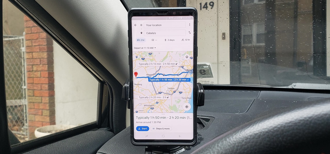

How To : See What Traffic Will Be Like at a Specific Time with Google Maps

As intuitive as Google Maps is for finding the best routes, it never let you choose departure and arrival times in the mobile app. This feature has long been available on the desktop site, allowing you to see what traffic should be like at a certain time and how long your drive would take at a point in the future. Fortunately, Google has finally added this feature to the app for iPhone and Android.
To try this out, you'll need to update your Google Maps app, which you can do with the links below. When you do, you'll be able to plan ahead by choosing arrival and/or departure times, which is ideal for seeing when you'll need to leave if you want to get to your destination by a specific time.
- Get the latest version of Google Maps: Android | iOS
Setting Departure or Arrival Times
Scheduling a trip based on either when you'd like to leave for, or arrive to a desired location couldn't be easier with Google maps — simply input your destination as you normally would within the the search field along the top of the screen. Tap on "Directions" after doing so to yield available routes.
Afterward, choose the best route a from the selections given. From there, tap on the three-dot menu button on the upper-right and hit "Set depart & arrive time" (Android) or "Set a reminder to leave" (iOS) from the prompt.
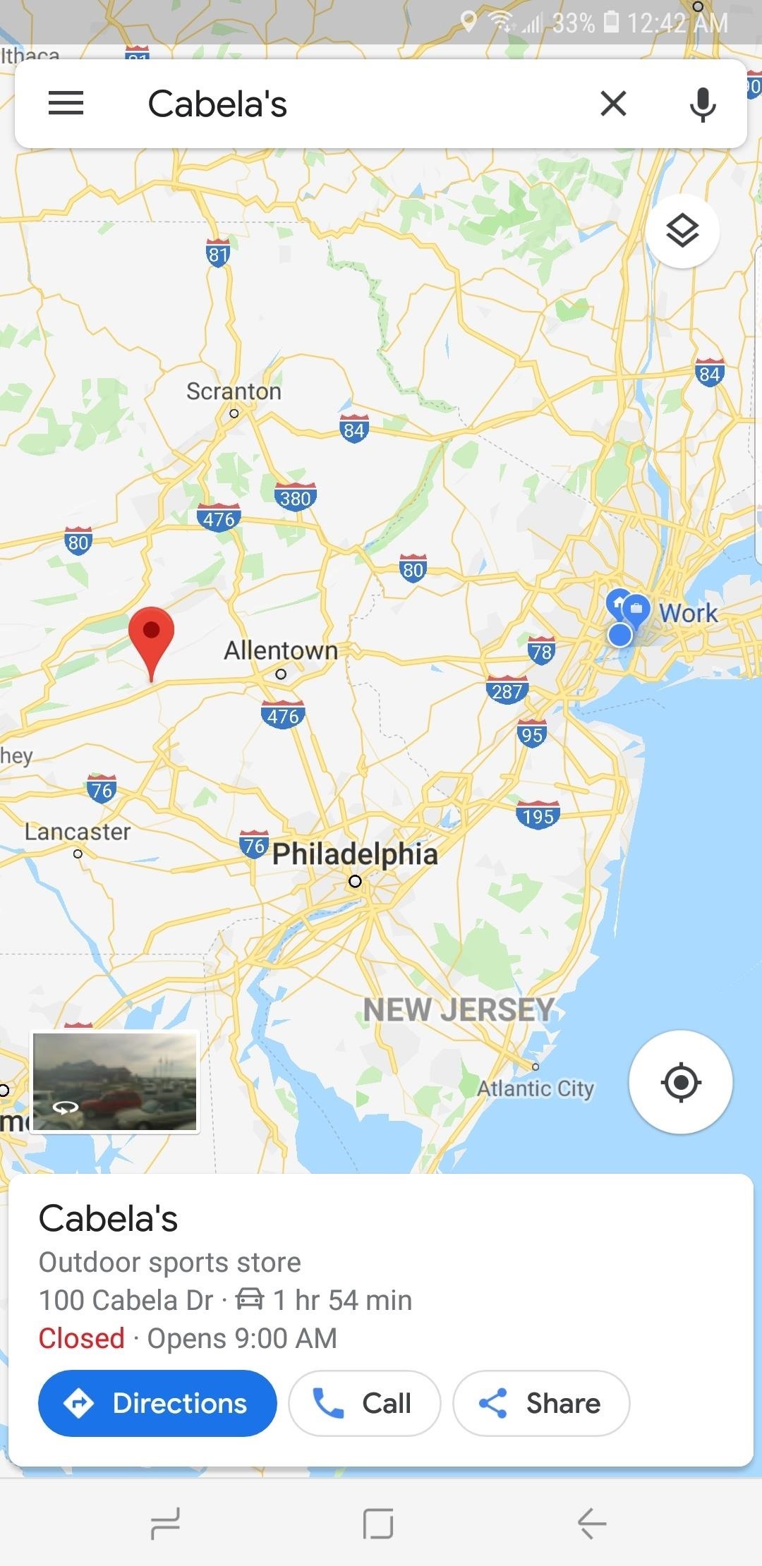
Now, either set the time and date you want to "Depart At" on the time table given, or tap on the "Arrive By" tab on the upper-right and adjust the time and date the same way if you want to arrive by a certain time. Hit "Set" once you're done, and Google Maps will yield average travel times for the route, along with either an ETA if you picked the former, or a suggested time for departure if you chose the latter.

As handy as this new feature is, it's worth noting that it does have some limitations. Google Maps currently won't alert you via a notification if you set a departure time. Besides that, traffic conditions aren't updated in real-time, so arrival times can vary, and drastically change due to unforeseen events like traffic accidents and sudden weather downturns.
- Follow Gadget Hacks on Pinterest , Reddit , Twitter , YouTube , and Flipboard
- Sign up for Gadget Hacks' daily newsletter or weekly Android and iOS updates
- Follow WonderHowTo on Facebook , Twitter , Pinterest , and Flipboard
Just updated your iPhone? You'll find new emoji, enhanced security, podcast transcripts, Apple Cash virtual numbers, and other useful features. There are even new additions hidden within Safari. Find out what's new and changed on your iPhone with the iOS 17.4 update.
Be the First to Comment
Share your thoughts, how to : the trick that lets you link to specific start times in youtube videos right from your phone, how to : redial busy phone lines automatically on your iphone or android phone, how to : find all the reels you liked & saved on instagram, how to : make spoofed calls using any phone number you want right from your smartphone, how to : prevent people who have your contact information from finding your instagram account, google photos 101 : how to track down & buy anything in your pictures with google lens, how to : connect your nest products to smartthings & trigger automations with your cameras or thermostats, telegram 101 : how to send self-destructing messages in chats, how to : we tested the best burner phone apps for iphone & android — here's our top 4, how to : change the background & chat bubble colors in all your telegram chats for a customized look, how to : completely disable your active status on facebook & messenger, google photos 101 : how to use google lens to save contact info from business cards, how to : 'airdrop' files from android to macos or ios devices (& vice versa), news : nvidia researchers have developed a 3d-printed prototype near-eye display for ar headsets, how to : the 5 best two-factor authentication apps for iphone & android, how to : the 5 best phones for video chat, arkit 101 : how to place grass on the ground using plane detection, how to : share your friends' instagram stories in your own story, how to : 9 ways to improve your mobile gaming experience.
- All Features
News : Mastercard Develops Mobile AR App to Explain Rewards & Benefits to Cardholders
- All Hot Posts
Google Maps 101: How AI helps predict traffic and determine routes
Sep 03, 2020
[[read-time]] min read

Every day, over 1 billion kilometers are driven with Google Maps in more than 220 countries and territories around the world. When you hop in your car or on your motorbike and start navigating, you’re instantly shown a few things: which way to go, whether the traffic along your route is heavy or light, an estimated travel time, and an estimated time of arrival (ETA). While all of this appears simple, there’s a ton going on behind the scenes to deliver this information in a matter of seconds.
Today, we’ll break down one of our favorite topics: traffic and routing. If you’ve ever wondered just how Google Maps knows when there’s a massive traffic jam or how we determine the best route for a trip, read on.
Live traffic, powered by drivers all around the world
When people navigate with Google Maps, aggregate location data can be used to understand traffic conditions on roads all over the world. But while this information helps you find current traffic estimates —whether or not a traffic jam will affect your drive right now —it doesn’t account for what traffic will look like 10, 20, or even 50 minutes into your journey. This is where technology really comes into play.
Predicting traffic with advanced machine learning techniques, and a little bit of history
To predict what traffic will look like in the near future, Google Maps analyzes historical traffic patterns for roads over time. For example, one pattern may show that the 280 freeway in Northern California typically has vehicles traveling at a speed of 65mph between 6-7am, but only at 15-20mph in the late afternoon. We then combine this database of historical traffic patterns with live traffic conditions, using machine learning to generate predictions based on both sets of data.
Recently, we partnered with DeepMind, an Alphabet AI research lab, to improve the accuracy of our traffic prediction capabilities. Our ETA predictions already have a very high accuracy bar–in fact, we see that our predictions have been consistently accurate for over 97% of trips. By partnering with DeepMind, we’ve been able to cut the percentage of inaccurate ETAs even further by using a machine learning architecture known as Graph Neural Networks–with significant improvements in places like Berlin, Jakarta, São Paulo, Sydney, Tokyo, and Washington D.C. This technique is what enables Google Maps to better predict whether or not you’ll be affected by a slowdown that may not have even started yet !
Keeping it fresh
For most of the 13 years that Google Maps has provided traffic data, historical traffic patterns have been reliable indicators of what your conditions on the road could look like—but that's not always the case. Since the start of the COVID-19 pandemic, traffic patterns around the globe have shifted dramatically. We saw up to a 50 percent decrease in worldwide traffic when lockdowns started in early 2020. Since then, parts of the world have reopened gradually, while others maintain restrictions. To account for this sudden change, we’ve recently updated our models to become more agile—automatically prioritizing historical traffic patterns from the last two to four weeks, and deprioritizing patterns from any time before that.
How Google Maps selects routes
Our predictive traffic models are also a key part of how Google Maps determines driving routes. If we predict that traffic is likely to become heavy in one direction, we’ll automatically find you a lower-traffic alternative. We also look at a number of other factors, like road quality. Is the road paved or unpaved, or covered in gravel, dirt or mud? Elements like these can make a road difficult to drive down, and we’re less likely to recommend this road as part of your route. We also look at the size and directness of a road—driving down a highway is often more efficient than taking a smaller road with multiple stops.
Two other sources of information are important to making sure we recommend the best routes: authoritative data from local governments and real-time feedback from users. Authoritative data lets Google Maps know about speed limits, tolls, or if certain roads are restricted due to things like construction or COVID-19 . And incident reports from drivers let Google Maps quickly show if a road or lane is closed, if there’s construction nearby, or if there’s a disabled vehicle or an object on the road. Both sources are also used to help us understand when road conditions change unexpectedly due to mudslides, snowstorms, or other forces of nature.
Putting it all together
So how exactly does this all work in real life? Say you’re heading to a doctor’s appointment across town, driving down the road you typically take to get there. When you leave the house, traffic is flowing freely, with zero indication of any disruptions along the way. With Google Maps’ traffic predictions combined with live traffic conditions, we let you know that if you continue down your current route, there’s a good chance you’ll get stuck in unexpected gridlock traffic about 30 minutes into your ride—which would mean missing your appointment. As a result, Google Maps automatically reroutes you using its knowledge about nearby road conditions and incidents—helping you avoid the jam altogether and get to your appointment on time.
Predicting traffic and determining routes is incredibly complex—and we'll keep working on tools and technology to keep you out of gridlock, and on a route that's as safe and efficient as possible.
Related stories

5 AI-powered tools to help you get outside more
Find more sustainable ways to get around, with new Maps and Search updates
New ways to power up your electric vehicle adventures with Google Maps
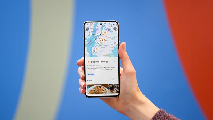
3 Maps updates to make summer travel a breeze

6 ways to travel smarter this summer using Google tools
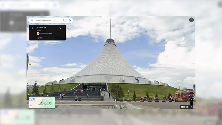
Street View comes to Kazakhstan
Let’s stay in touch. Get the latest news from Google in your inbox.
How Google Maps uses DeepMind’s AI tools to predict your arrival time
A lot of data and a lot of neural networks.
By James Vincent , a senior reporter who has covered AI, robotics, and more for eight years at The Verge.
Share this story
:format(webp)/cdn.vox-cdn.com/uploads/chorus_asset/file/21849025/1211180776.jpg.jpg)
Google Maps is one of the company’s most widely-used products, and its ability to predict upcoming traffic jams makes it indispensable for many drivers. Each day, says Google, more than 1 billion kilometers of road are driven with the app’s help. But, as the search giant explains in a blog post today, its features have got more accurate thanks to machine learning tools from DeepMind , the London-based AI lab owned by Google’s parent company Alphabet.
In the blog post, Google and DeepMind researchers explain how they take data from various sources and feed it into machine learning models to predict traffic flows. This data includes live traffic information collected anonymously from Android devices, historical traffic data, information like speed limits and construction sites from local governments, and also factors like the quality, size, and direction of any given road. So, in Google’s estimates, paved roads beat unpaved ones, while the algorithm will decide it’s sometimes faster to take a longer stretch of motorway than navigate multiple winding streets.
:format(webp)/cdn.vox-cdn.com/uploads/chorus_asset/file/21849021/Google_Maps_ETAs_2x.png)
All this information is fed into neural networks designed by DeepMind that pick out patterns in the data and use them to predict future traffic. Google says its new models have improved the accuracy of Google Maps’ real-time ETAs by up to 50 percent in some cities. It also notes that it’s had to change the data it uses to make these predictions following the outbreak of COVID-19 and the subsequent change in road usage.
“We saw up to a 50 percent decrease in worldwide traffic when lockdowns started in early 2020.”
“We saw up to a 50 percent decrease in worldwide traffic when lockdowns started in early 2020,” writes Google Maps product manager Johann Lau. “To account for this sudden change, we’ve recently updated our models to become more agile — automatically prioritizing historical traffic patterns from the last two to four weeks, and deprioritizing patterns from any time before that.”
The models work by dividing maps into what Google calls “supersegments” — clusters of adjacent streets that share traffic volume. Each of these is paired with an individual neural network that makes traffic predictions for that sector. It isn’t clear how large these supersegments are, but Googles notes they have “dynamic sizes,” suggesting they change as the traffic does, and that each one draws on “terabytes” of data. The key to this process is the use of a special type of neural network known as Graph Neural Network, which Google says is particularly well-suited to processing this sort of mapping data.
For more detail, check our the blog posts from Google and DeepMind here and here .
Hands-on with the new iPad Pro: yeah, it’s really thin
The 7 biggest announcements from apple’s ipad event, apple announces new ipad pros with oled displays and thinnest design ever, apple ipad event: all the news from apple’s ‘let loose’ reveal, apple’s new magic keyboard makes the ipad pro feel ‘just like’ a macbook.
More from Tech
:format(webp)/cdn.vox-cdn.com/uploads/chorus_asset/file/24365737/Wyze_Cam_OG_Telephoto_8.jpg)
Wyze cameras let owners see into a stranger’s home — again
:format(webp)/cdn.vox-cdn.com/uploads/chorus_asset/file/24049860/226292_Apple_Watch_SE_PHO_akrales_0047.jpg)
Here are the best Apple Watch deals right now
:format(webp)/cdn.vox-cdn.com/uploads/chorus_asset/file/24247717/lp_logo_3.0.jpg)
OpenAI can’t register ‘GPT’ as a trademark — yet
:format(webp)/cdn.vox-cdn.com/uploads/chorus_asset/file/25184511/111323_PlayStation_Portal_ADiBenedetto_0013.jpg)
Sony’s portable PlayStation Portal is back in stock
Maps Platform
Predicting the future with google maps apis.
- 5 Great Maps
- advertising
- Autocomplete
- Bruce Springsteen
- Code for America
- Computerlogy
- creative advertising campaigns
- Custom Map Types
- Developer Challenge
- Developer stories
- Directions API
- Drawing Tools
- Driving Directions
- Elevation API
- environment
- Fusion Tables
- Geodesic Lines
- Global Economy
- Google Analytics
- Google App Engine
- Google Earth
- Google Earth API
- Google Maps
- Google Maps API
- Google Maps Engine
- Google Places API
- Google Places API Developer Challenge
- Google Street View API
- Latitude API
- local search
- Map of the Week
- Maps API for Flash
- Maps Data API
- Marker Clusterer
- More Than a Map
- Morethanamap
- Neighborhoods
- New York City
- Office Hours
- Place Summaries
- public transit
- public transit layer
- real estate
- South Africa
- Spatial Data Files
- Static Maps API
- street view
- Styled Maps
- traffic layer
- Transportation
- United Nations
- Vancouver Olympics
- visualizations

Give us feedback in our Product Forums .
Company-wide
- Official Google Blog
- Public Policy Blog
- Student Blog
- Android Blog
- Chrome Blog
- Lat Long Blog
- Developers Blog
- Ads Developer Blog
- Android Developers Blog
Predicting Future Travel Times with the Google Maps APIs
By: ancoris says tag(s): geolocation published: nov 12, 2015.
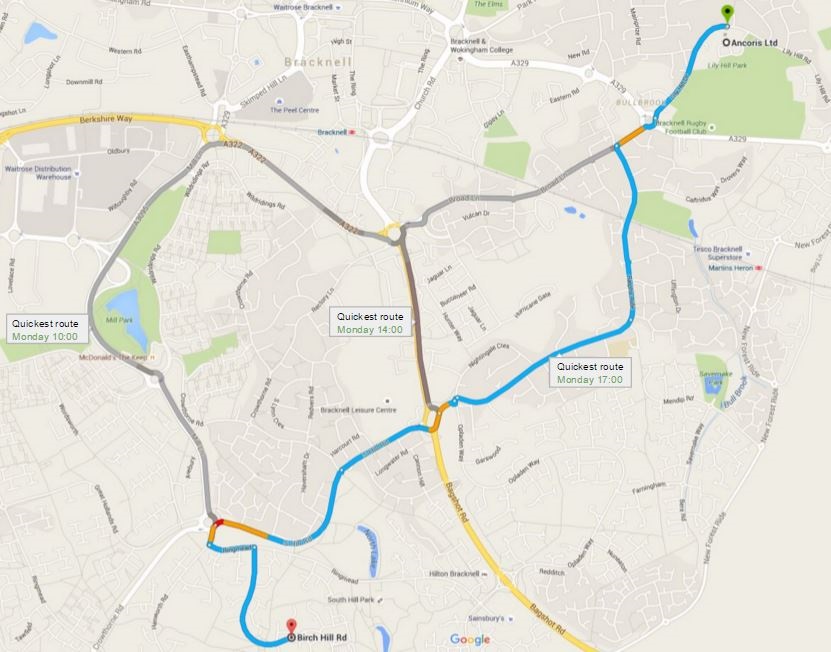
Hundreds of successful applications in transport, retail, travel and utilities use the Google Maps Platform and Google location services to get directions, optimise deliveries, estimate miles, organise assets, calculate fares, find closest geolocation by travel time and so on. There has however been a limitation to plan journeys ahead of time and predict travel times for different days and times.
Not any more. A new feature in the Maps APIs called predictive travel times, will use historical time-of-day and day-of-week traffic data to estimate travel times at a future date. This makes it easier than ever to predict how long it will take to get somewhere and suggest the best route even when the departure time is far in the future.
I can think of some really interesting and innovative ways this could be used to help businesses engage with customers and improve efficiencies, for example:
Optimising route planning and delivery times
A parcel delivery company could schedule deliveries and provide estimated time of arrivals to customers to maximise the number of deliveries and reduce missed drops.
Mobile workforce management
A business with a mobile workforce could schedule jobs for workers and give them a departure time to ensure they reach jobs at the scheduled time. Arrival time could then be communicated to customers.
Travel planning as part of external application
A travel website could allow users to plan a day's sightseeing itinerary, calculating if they can see all the sites in a day and working out the optimum departure time to complete the itinerary.
Tracking companies
Tracking and telematics solution providers could add functionality to their solution, for example predicting when assets will arrive at their destination as well as improving scheduling modules.
There are many other potential uses for predictive travel time and I am sure you can think of a couple of innovative uses in your own business to help engage with customers, improve efficiencies and provide amazing customer experience. Let's get to work on doing this and making Google Maps even more valuable for your business.
Working with a Google Maps Premier Partner
A Google Cloud Partner like Ancoris can help you apply the power of Google Maps to solve current business challenges and develop new digital models using location-based services .
We’re not only a Google Maps Premier Partner but have achieved Google’s Location-Based Services Partner Specialisation. This means we’ve demonstrated both technical proficiency and proven success in building and managing applications using the best of Google Maps Platform and Google Cloud Platform in both web and mobile environments.
If you’d like to find out more about how we can help you, why not take a look at some of our customer success stories or talk to the experts in our Google Maps team .

< Back to resources
Think big. Start now.
We don’t believe in Innovation, we live it. Innovation combined with pragmatism is what runs through our veins. We ask ourselves the same question over and over again: Does it deliver value? And how quickly? Your big ambitions can start now.
Talk to an Expert
- Meta Quest 4
- Google Pixel 9
- Google Pixel 8a
- Apple Vision Pro 2
- Nintendo Switch 2
- Samsung Galaxy Ring
- Yellowstone Season 6
- Recall an Email in Outlook
- Stranger Things Season 5
Google Maps will now tell you the best time to hit the road

The feature is already live on our devices, so Google might not be doing a lengthy rollout with this particular new feature. The information is presented as a bar graph that looks very similar to the one used to denote hours when businesses are busiest. You can even look one hour in the past, to kick yourself over how much time you might have saved if you just left a little earlier.
The feature is only available in the United States and United Kingdom, according to Android Central , and didn’t accompany an app update — meaning users in other regions will have to wait for Google to flip it on.
Google sources traffic data all day, all around the world, so it’s nice to see it used to deliver a new tool that makes driving easier and traffic jams less unexpected.
- Whatever you do, don’t buy the Google Pixel 7a right now
- Google Messages vs. Samsung Messages: Which app should you use?
- Google is bringing Chrome browser to cars, even more EV features to Maps
Every couple of months, Google quietly updates Maps with helpful little features, like a parking availability indicator or floor plans with marked staircases and elevators to denote wheelchair-accessible places. It can honestly be difficult to stay on top of everything you can do with Maps, which is why we’ve written a guide featuring the most useful tips and tricks .
At the same time, the company has been fighting back against problems like fake listings for locations and businesses that are aimed at extorting travelers. According to Google, about 70 percent of these listings have been weeded out over the past two years. New policies instituted since then have prevented unverified businesses from creating listings in bulk, or registering locations far away from their existing operation. Google says most of the offenders are now identified before they ever appear to the public.
Editors' Recommendations
- A new Google Pixel Tablet is coming, but it’s not what you think
- These are the best Android 15 features you need to know about
- Don’t update your Google Pixel phone — you might break it
- Google is paying a $700 million fine, and you’re getting some of it
- I used to love the Google Pixel Fold. Now, I’m not so sure

Over the past few weeks, Google has been quietly rolling out a fresh coat of paint for its popular Google Maps app — and it’s been creating havoc over the holiday travel season.
While some people may understandably be frustrated at any changes made to such an established and widely used app, there seems to be more to this than just people being put off by unfamiliar colors. The many folks taking to social media to voice their displeasure with the redesign have been joined by professional user interface (UI) designers expressing similar, but more nuanced observations. Even a designer who once worked on Google Maps is pillorying the new design as a backward step for the service’s usability.
Google introduced a major update for Maps on Thursday, adding a bunch of new features that make the app even more powerful.
The company has been working hard to bring AI smarts to its suite of tools in recent months, and so it’s no surprise to see Google Maps getting some attention in this area.
Google has been accused of negligence after a man drove off a broken bridge while allegedly following directions on Google Maps.
Philip Paxson drowned after the Jeep Gladiator he was driving fell about 20 feet (6.1 meters) and landed upside down in a river in Hickory, North Carolina, about 60 miles northwest of Charlotte.
DeepMind claims its AI improved Google Maps travel time estimates by up to 50%
- Share on Facebook
- Share on LinkedIn
Are you looking to showcase your brand in front of the gaming industry’s top leaders? Learn more about GamesBeat Summit sponsorship opportunities here .
DeepMind today detailed a collaboration with Google that reportedly improved the accuracy of real-time driving ETAs in Google Maps and Google Maps Platform APIs by up to 50% in some regions, including Berlin, Jakarta, São Paulo, Sydney, Tokyo, and Washington D.C. Through the use of machine learning techniques, DeepMind claims it minimized traffic prediction inaccuracies by incorporating relational learning biases that model road networks.
Google Maps analyzes live traffic for roads around the world to calculate ETAs, which gives the platform a picture of current traffic but doesn’t account for conditions drivers can expect to see 10, 20, or 50 minutes into their route. Google Maps relies on machine learning to combine traffic conditions with historical patterns for roads worldwide. To achieve this at scale, DeepMind developed an architecture called graph neural networks that conducts spatiotemporal reasoning.
Google Maps divides road networks into “supersegments” consisting of multiple adjacent segments of road that share significant traffic volume. A route analyzer processes terabytes of traffic information to construct the supersegments, while the graph neural network model — which is optimized with multiple objectives — predicts the travel time for each supersegment.

The AI Impact Tour – San Francisco
Join us as we navigate the complexities of responsibly integrating AI in business at the next stop of VB’s AI Impact Tour in San Francisco. Don’t miss out on the chance to gain insights from industry experts, network with like-minded innovators, and explore the future of GenAI with customer experiences and optimize business processes.
Because the graph neural network can generalize, each supersegment can be of varying length and complexity, from two-segment routes to longer routes containing hundreds of nodes. DeepMind says its experiments have achieved gains in predictive power by expanding to include adjacent roads. “For example, think of how a jam on a side street can spill over to affect traffic on a larger road,” the company wrote in a blog post. “By spanning multiple intersections, the model gains the ability to natively predict delays at turns, delays due to merging, and the overall traversal time in stop-and-go traffic.”
MetaGradients dynamically adapt the graph neural network’s learning rate during training to let the system learn its own optimal learning rate schedule. According to DeepMind, by automatically adapting the learning rate while training, the model not only achieves higher quality than before but learns to decrease the learning rate automatically, leading to more stable results.
“Thanks to our close and fruitful collaboration with the Google Maps team, we were able to apply these novel and newly developed techniques at scale,” DeepMind continued. “Together, we were able to overcome both research challenges as well as production and scalability problems. In the end, the final model and techniques led to a successful launch.”
DeepMind’s work with the Google Maps team follows the lab’s other partnerships with Google product divisions, including an effort to improve the Google Play Store’s discovery systems. Beyond Google, DeepMind has contributed algorithms, frameworks, and methodologies to bolster Waymo’s autonomous driving systems.
Stay in the know! Get the latest news in your inbox daily
By subscribing, you agree to VentureBeat's Terms of Service.
Thanks for subscribing. Check out more VB newsletters here .
An error occured.
Official Blog
Predicting future travel times with the google maps apis.
- If your application is used for scheduling deliveries, and you want to ensure you’ve allowed enough time between deliveries so your drivers won’t be late, you might want to use the pessimistic travel time estimates.
- On the other hand, if you’re building a thermostat app, and you want the house to be warm by the time your user arrives home from work, you might want to use the optimistic travel time estimate to calculate when the user is likely to arrive.
- If you want to give your user an estimate of the most likely travel time to their destination, the default best_guess traffic model will give you the most likely travel time considering both current traffic conditions and historical averages.
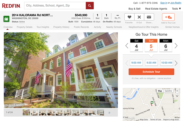
“Taking the guesswork out of knowing how long it will take to drive between homes will help us provide a better customer experience to our users” – Curtis Howell, Product Manager Customer Engagement, Redfin
- #innovationupgrade
- #InspireGirls
- #moregoogleapps
- #SysAdminDay
- #throwbackthursday
- #top10trust
- Admin console
- Android for Work
- Android for Work Live
- Android Marshmellow
- Android Nougat
- Android security
- Android security tips
- Apps Adventures
- apps script
- Armed Forces Day
- Asia Pacific
- Atmosphere Live
- Audi Connect
- Chomebox for Meetings
- Chrome Device Management
- Chrome digital signage
- Chrome for Business
- Chrome for Work
- Chrome Frame
- Chromebooks
- Chromebooks for Business
- Chromebooks for Education
- Chromebooks for Work
- Chromebox for digital signage
- Chromebox for meetings
- Chromebox for signage
- Chromeboxes
- Clearing Kosovo
- cloud computing
- cloud computing gonegoogle
- cloud computing gonegoogle Google Apps
- cloud computing gonegoogle Google Apps google docs small business success story
- cloud computing gonegoogle Google Apps google docs small business success story switch
- cloud datastore
- cloud platform
- Cloud Platform Live
- cloud print
- cloud series
- cloud services
- collaboration
- Control Panel
- customer love
- Customer story
- Customer support
- Customer testimonial
- data centers
- data processing amendment
- data protection
- Digital Learning Day
- Drive for Education
- drive sharing
- earth and maps
- Education on Air
- Global Partner Summit
- Gone Google
- Google AdWords
- Google App Engine
- Google Apps
- Google Apps Blog
- Google Apps for Business
- Google Apps for Education
- Google Apps for Government
- Google Apps for Work
- Google Apps Marketplace
- Google Apps Reseller
- Google Apps Script
- Google Apps Vault
- Google BigQuery
- Google Calendar
- Google Calendar app
- Google Certified Teachers
- Google Chrome
- Google Chromebases
- Google Classroom
- Google Cloud Datastore
- Google Cloud DNS
- Google Cloud Platform
- google cloud storage
- Google Cloud Vision API
- google commerce search
- Google Compute Engine
- Google Docs
- Google Domains
- Google Draw
- Google Drive
- Google Drive for Work
- Google Earth
- Google Earth Engine
- Google Earth Enterprise
- Google Earth Images
- Google Earth Pro
- Google Email Security and Archiving
- Google Enterprise
- Google Enterprise Search
- Google Expeditions
- Google for Education
- Google for Education Partner Program
- Google for Education Training Center
- Google for Entrepreneurs
- Google for Work
- Google for Work and Google for Education Partner Program
- Google for Work partner program
- Google Forms
- Google Green
- google groups
- Google Hangout
- Google Hangouts
- Google Keep
- Google Maps
- Google Maps API
- Google Maps APIs
- Google Maps Coordinate
- Google Maps Engine
- Google Maps Engine Pro
- Google Maps Engine public data program
- Google Maps for Business
- Google Maps for Work
- Google Maps Gallery
- Google Maps Tracks API
- Google Message Continuity
- google message security
- Google Mobile Device Management
- Google My Maps
- Google My Maps Pro
- Google Places API
- Google Play
- google play for education
- Google Prediction API
- Google Research tool
- Google Science Fair
- Google Search Appliance
- Google Security Key
- Google Sheets
- Google Site Search
- google sites
- Google Slides API
- Google Smart Lock
- Google spreadsheets
- Google Springboard
- google storage
- Google Storage for Developers
- Google Translate
- Google Vault
- Google Video
- Google Wave
- Google+ api
- Google+ Communities
- GSA for Commerce
- Hangout on Air
- Hangouts on Air
- hints and tips
- Inbox by Gmail
- international trade
- Internet Explorer
- large business
- manufacturing
- Mapping a better world
- marketplace
- marketplace highlights
- medium business
- mobile management
- model contract clauses
- Mother's Day
- mpstaffpick
- new features
- Niagara International Transportation Technology Coalition
- OpenID Connect
- Partner Showcase
- Place Summaries
- product ideas
- productivity
- Quickoffice
- Receptionist's Day
- Safer Internet Day
- Security Key
- small business
- Small Business Week
- Small businesses
- spam and security trends
- success story
- System Admin
- Teamwork 2015
- Thanksgiving
- Transport and Logistics
- University of Calgary
- Veteran Owned Businesses
- Veterans Day
- Veterans Day 2013
- Veterans Day 2014
- women in tech
- Women's History Month
- Work Resolutions
Useful Links
Company-wide.
- Official Google Blog
- Public Policy Blog
- Student Blog
- Android Blog
- Chrome Blog
- Lat Long Blog
- Developers Blog
- Ads Developer Blog
- Android Developers Blog
How to Predict Traffic on Google Maps for Android
Google Maps has plenty of features which enhance your driving experience. I keep discovering new features like inbuilt fare prediction, crash and speed trap reporting, and traffic prediction. My favorite is the real-time traffic prediction but there is a hidden feature which lets you predict traffic at a certain time. In this guide, I’ll show you how to predict traffic on Google Maps for Android. Let’s get started.
Google Traffic prediction is based on several factors including Public sensors, GPS data, and analysis of the past record of traffic in the area. All of these parameters help you give an accurate and real-time traffic update. This data can also be used to predict traffic in future. For the most part, this data is usually accurate, unless there is a recent change in patterns like construction or a crash at the site.
Read: Now You Can Share Your Real-Time Location with Google Maps
How To Predict Traffic on Google Maps
To see the prediction of the traffic, First, open the Google Maps app on your Android Smartphone. Tap the Directions button on the bottom right.

Now, enter the starting point and destination details in the input fields to generate a route for your commute.

You’ll see the real-time traffic patches in red on the blue route. Tap on the options button (three vertical dots) on the top right.
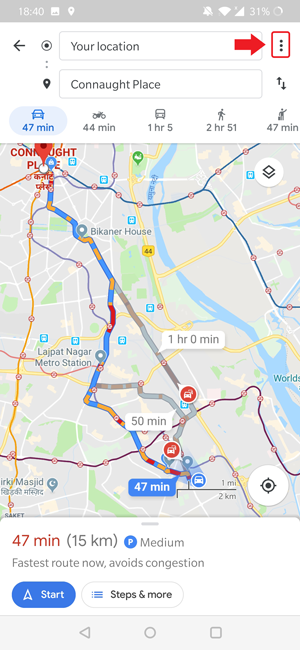
Select ‘ set depart & arrive time ‘ to open a new pop up window. Here you can select Time and date of your departure or arrival and tap set .

Google Maps would automatically generate a route at the time with Traffic predictions of that hour.

This is how you predict traffic at odd hours on Google Maps. Unfortunately, you can only use this feature in Android. Even though Google Maps app for iOS is similar to Android, you don’t get traffic preview for that time. Here’s how you can set a reminder for a route on Google Maps for iOS.
Set a Reminder on iOS
Open the Google Maps app on your iOS device, and generate a route by tapping the direction button.

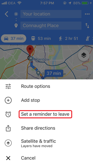
Enter the starting and destination point . After the route is mapped, tap the options button (three horizontal dots) on the top right.

It would open a dialog window with a couple of options. Tap ‘ Set a reminder to leave ‘ to set the time and date for the notification. After Adjusting the time and date, tap ‘ SET REMINDER ‘. You’ll receive a notification when it’s time to leave for your commute.
Must Read: Best Travel Management Apps for Android and iOS
Predict Traffic on Google Maps for Android
Traffic prediction was long available on the desktop site and it’s good to see it coming on Android as well. You can seldom predict what’s on the road and Google helps remove a chunk of probability from the scenario. Of course, there are always a few things which would be inevitable but in normal situations, Google maps fares well. Tell us which Google Maps features do you love the most in the comments below.
Works as an in-house Writer at TechWiser and focuses on the latest smart consumer electronics. Closely follows the latest trends in consumer IoT and how it affects our daily lives. You can follow him on Twitter. Yes, he sometimes speaks in Third Person.
You may also like
How to check battery health on android, 2 ways to hide navigation gesture bar on..., how to enable double/triple back tap on samsung..., how to check storage type and speed of..., 4 best airpods apps for android to get..., 10 ways to fix circle to search not..., this is the best way to lock whatsapp..., you’re using your galaxy phone wrong if you..., how to lock apps on your samsung galaxy..., how to switch back to google assistant from..., leave a comment cancel reply.
You must be logged in to post a comment.
- Help Center
- Google Maps
- Privacy Policy
- Terms of Service
- Submit feedback
Plan your commute or trip
Find traffic & transit info.
You can use Google Maps to quickly find all of your frequent trips in one tap. You’ll get information about your ETA, the traffic reports and the accidents along the way.
Tip : To show the map, tap anywhere on the map or drag the tabs back down.
Change the way you commute
- Search for your destination in the search bar at the top.
- At the bottom, tap on “Directions.”
- At the top, select your transportation mode.
- Select your preferred route.
You can pin your trip and find it back in the Go tab next time you need it.
Turn off your regular routes
If your Location History is on, we might show you directions for your regular routes. If you don't want the routes you take regularly to be associated with your Google Account, you can turn off your Location History.
Note: Your regular routes are only visible to you.
- Scroll to “Location settings.”
- Tap Location is on .
- At the top, turn off Location History.
Check traffic now & later
To reach your destination as quickly as possible, check typical traffic before you drive. You can avoid the busiest times of day.
- Search for a destination, or tap a place on the map.
- At the bottom, tap Directions .
- The current traffic on your route
- Typical traffic by the hour and any slowdowns on the way
Change the mode of transportation for part of your trip
Tip: Only available on mobile and in some locations.
You can combine different modes of transportation, like driving, ride-sharing, or bicycling with transit on the same trip.
Once you’ve selected your route and can view the directions, you may be able to change how you travel for part of your trip. The rest of the route, like transit departure times and total journey time, will be updated when you change the mode of transportation.
Was this helpful?
Need more help, try these next steps:.
Create efficient and optimized routes
Real-time traffic.
Improve business efficiency with up-to-date traffic data.
Global routing
Provide comprehensive routes in over 200 countries and territories.
Routing at scale
Count on infrastructure that serves over one billion users.
Discover new Routes features
More informative and flexible routes.
Access 2-wheel motorized vehicle routes, real-time traffic information along each segment of a route, and calculate tolls for more accurate route costs.
Improved ETA accuracy
Specify whether a waypoint is a pass-through or stopping location. Choose the side of the road or the desired vehicle direction for each waypoint.

Controls for reduced latency
Choose to optimize for quality or latency in traffic, polylines, data fields returned, and more.
Offer more sustainable routing options
Optimize for lower fuel consumption.
Provide a range of routes to choose from, based on estimated fuel consumption.
Estimate fuel efficiency
Get more accurate fuel and energy use estimates based on engine type and real-time traffic.
Plan for a sustainable future
Work toward a long-term emissions reduction plan.
Predicting future travel times with the Google Maps APIs
Elena kelareva.
Product Manager, Google Maps APIs
- If your application is used for scheduling deliveries, and you want to ensure you’ve allowed enough time between deliveries so your drivers won’t be late, you might want to use the pessimistic travel time estimates.
- On the other hand, if you’re building a thermostat app, and you want the house to be warm by the time your user arrives home from work, you might want to use the optimistic travel time estimate to calculate when the user is likely to arrive.
- If you want to give your user an estimate of the most likely travel time to their destination, the default best_guess traffic model will give you the most likely travel time considering both current traffic conditions and historical averages.

“Taking the guesswork out of knowing how long it will take to drive between homes will help us provide a better customer experience to our users” – Curtis Howell, Product Manager Customer Engagement, Redfin
- Inside Google Cloud
Related articles

What’s new with Google Cloud
By Google Cloud Content & Editorial • 3-minute read
What’s new with Google Cloud - 2023
By Google Cloud Content & Editorial • 29-minute read

Shared fate: Protecting customers with generative AI indemnification
By Neal Suggs • 4-minute read

“The time is now.” Why this Kenyan Googler is betting on Africa’s tech opportunity
- Google Maps Platform
- Español – América Latina
- Português – Brasil
- Tiếng Việt
- Web Services
- Documentation
Specify the traffic model type to use
Traffic models use specific algorithms and factors to predict how traffic conditions impact total travel time for a given route. The Routes API offers different traffic model types to prioritize different factors used in calculating duration in traffic. You can specify the traffic model type you'd like your routes to use when calculating the duration for your routes or route matrix. When you set the traffic model type, the value returned in the duration field varies depending on the traffic model you choose.
Both the Routes API Compute Routes and Compute Route Matrix methods support traffic model types.
By default, both methods use the BEST_GUESS traffic model type.
To specify a traffic type
Set your origin and destination.
If your departure time is in the future, include the time using the departure_time parameter. If you don't specify a departure time, it defaults to now.
Select the traffic model to use with the trafficModel parameter and one of the following types:
BEST_GUESS (default) to request that the returned duration_in_traffic is the best estimate of travel time given what is known about both historical traffic conditions and live traffic. Live traffic becomes more important the closer the departure_time is to now. Using the default type of BEST_GUESS gives the most useful predictions for the vast majority of use cases.
PESSIMISTIC to request that the returned duration_in_traffic models the time based on the historical traffic conditions on bad traffic days. This type gives an estimated duration that is most likely longer than the actual travel time on most days. Occasional days with particularly bad conditions may still exceed this estimate.
OPTIMISTIC to request that the returned duration_in_traffic models the time based on the historical traffic conditions on good traffic days. This type gives an estimated duration that is most likely shorter than the actual travel time on most days. Occasional days with particularly good conditions may still be faster than this estimate.
For example: "trafficModel": "OPTIMISTIC"
Specify the routes.duration field in the field mask.
When the Routes API estimates time in traffic, it uses the traffic model type you've requested.
Example: Traffic model request
For example, this request specifies that the duration be estimated using the OPTIMISTIC traffic model type at a specific departure time:
This request returns the estimated duration using the OPTIMISTIC traffic model type for the trip:
If you change the traffic model type to PESSIMISTIC , the returned duration is longer:
Except as otherwise noted, the content of this page is licensed under the Creative Commons Attribution 4.0 License , and code samples are licensed under the Apache 2.0 License . For details, see the Google Developers Site Policies . Java is a registered trademark of Oracle and/or its affiliates.
Last updated 2024-05-03 UTC.

Unlock your adventure: 5 Google Maps features to transform travel
A s vacation time rolls around, Google Maps often tops the list of essential apps. While many associate it mainly with GPS navigation, they might overlook its other features that make trip planning and exploration a breeze.
Google Maps is more than just an app; it's an evolving tool packed with features beyond simply getting you from point A to point B. As we approach the May break, let’s uncover five Google Maps features that could be game-changers for your travels.
Find friends easily by sending a pin
Have you ever struggled to meet friends in a crowded place? Google Maps offers a simple solution: send a pin. This feature allows you to share your exact location, which gets loaded into your friend's navigation, guiding them directly to you. It’s the perfect way to connect in busy areas without confusion.
Plan with a bird’s-eye view in Immersive Mode
One of Google Maps' newer features is the immersive view. It combines high-quality satellite photos with Street View imagery, using artificial intelligence to blend the two seamlessly. This gives you a unique perspective of landmarks and places around the globe. With immersive mode, you can get a virtual feel of your destination and play with different times of day and weather conditions, making your planning even more realistic.
Use Street View for precise navigation
Street View, a well-known feature within Google Maps, offers on-the-ground photos of locations captured by Google’s vehicles or individuals with special camera-equipped backpacks. This feature is invaluable for drivers and explorers, allowing you to familiarize yourself with a location before you even set foot there.
Measure distances with ease
Download maps for offline use.
Navigating in areas with spotty or no internet connection? Google Maps lets you download maps to your phone for offline use. This feature is a lifesaver for conserving mobile data and ensures you’re never without a map, even in the most remote locations. Select the map area you need, and you're ready to go.
Google Maps is undeniably more than a navigation app. It’s a comprehensive travel tool that continues to add new features, making it indispensable for modern adventurers. Remember these tips to make the most of your next journey.
Google Maps expands 3D buildings feature to more Android Auto users: potential orientation aid with controversial convenience
Google Maps to phase out Car Mode by 2024, voice assistant to harness safer driving
Google Maps update sparks privacy concerns with listening feature

12 Google Maps Secrets All Travelers Should Know
If you’re only opening google maps for driving directions, you’re not leveraging the app’s full potential. here are 12 other ways travelers can use it to improve their trips, in advance and on the fly..
- Copy Link copied

As a travel editor, I use Google Maps daily. These are some of the most useful features for trip planning I’ve found.
Photo by Mojahid Mottakin/Shutterstock
I’m a nerd for maps. As a kid, they inspired me to want to travel, and as an adult they’re my comfort reading. My colleagues at Afar even let me make a podcast episode about them . But of all the maps I love (Middle-earth included), the one I spend the most time with these days is Google Maps. I’m betting most of you can say the same thing. I’m on that app every single day. I use it for work (for the research I need to do in my job here as an editor and writer), I use it for fun (I can spend hours armchair exploring remote islands in the middle of oceans), and I use it, most invaluably, for trip planning. If you’re only using Google Maps for directions, you’re missing out. Here are a dozen ways I use Google Maps for smarter travel.
Collaborate an itinerary with friends
I make Google Maps lists of everything: I have one for vegetarian restaurants, another for ice cream shops—I even have one that’s a cocktails and cookies trail. (I created that last one with my cousin when we celebrated her 21st birthday.) More often, I use lists as a trip-planning tool. As I’m researching things to do in whatever destination I’m headed to (recently Argentina, Nairobi, and Manchester ), I create a list, add places of interest (museums, restaurants, shops, libraries, etc.) and share it with my travel crew so that they can weigh in on my picks and add their recommendations. While that’s useful, it’s only 101.
In the past year, lists have leveled up: Now, for each place listing, your friends can react with an emoji (heart, smile, fire, thumbs down, or flying money) and add their tips and suggestions into a comments field (e.g., “I read that dulce de leche is the flavor to get!” or “Let’s go here after our street-art tour on Monday.”). I especially like that I can customize the order of the items on the list; for example, I could make them match the path of cookies I plan to follow, or I could arrange our collective Argentina picks chronologically so that the list doubles as our itinerary. A fun bonus is that you can assign any emoji to the whole list so that all of the places show up in map view with that themed icon—say, the Argentina flag or an ice cream cone.
Walk like you know where you’re going with navigation

The Glanceable Directions feature puts a minimap on your lock screen.
Photo by Billie Cohen
Turn-by-turn navigation isn’t just for drivers. Google Maps offers it for walkers and bikers too. Once you type in your destination, select “directions,” then “walking,” then “start navigation,” and the app will speak out loud to guide you, the same as if you were in a car. When I’m in a new city, I use this with one earbud in so I don’t have to keep looking at my phone (because I will inevitably trip and fall over).
If you prefer to look at your phone, you can follow your route in both 2D (that little blue arrow moving on the map) or in 3D Live View. In this mode, you point your camera at the real world to get the app situated and then follow arrows and directions overlaid on the IRL view of the streets that you see through your phone. (Another settings option allows you to tilt your phone to enter Live View rather than tap.) Even more helpful, the recently released Glanceable Directions feature shows a minimap and navigation on your lock screen, so you don’t have to open the app and turn on comprehensive navigation mode to get the benefits (toggle this feature on in settings). Conveniently, it’ll automatically reroute if you take a different path.
Use augmented-reality Lens to find what’s nearby: shops, restaurants, ATMs, and more

When in the Lens function, Google Maps puts street names and building information on the view around you.
In addition to navigating with augmented-reality Live View, you can also use an augmented-reality (AR) function called Lens in Maps to see what’s around you, including restaurants, public transportation stops, and landmarks. When in Maps, tap the little camera icon in the search bar, then point your phone at the street, and you’ll start to see icons on the buildings. Note that this feature works only for select locations, but new cities are consistently rolling out. In the meantime, all of this information is still easily available in the app: Right under the search bar, you’ll see popular search categories, including gas, restaurants, hotels, and groceries—and be sure to scroll all the way over to the “More” button. Tap that to see a couple dozen additional, and very specific, categories, including ATMs, libraries, live music, hospitals, pharmacies, and even EV charging stations.
Plan your EV charging route
Speaking of EV charging stations, Maps has expanded the info it provides on electricity pumps. To find them while you’re on an EV road trip , type or speak “charging stations” into the search field or tap the “More” category button directly under the search bar. You’ll immediately see red pins with a little lightning bolt inside them populate the map. In the information card below, the app will tell you which kind of chargers a station has (fast, medium, slow), how many are available, and whether they’re compatible with your car.
Check what’s open right now
When I was in Manchester last year, my friends and I went to a concert that let out late, and instead of heading directly to bed, we wanted to go out for a drink and a bite to eat. That’s when I pulled out Maps to check what places were still open around us. In the app, look for “open now”—it’s one of the options right under the search bar.
Use photos to get a sense of a place before you go
Nearly every listing in Google Maps has photos now, culled from public reviews and the establishments’ owners. Admittedly, this isn’t so much of a secret—but it is a secret weapon. You can use those photos to evaluate hotels, to check if a coffee shop is comfortable for laptop working, to see if a restaurant is likely to fit your big group or your mood, and to view images of menus. A recent AI-powered update uses those photos to give more travel inspiration. Try typing something like “cherry blossoms,” “public art,” or “swimming holes” into the search bar, and the results will include a carousel of photos and videos culled from public uploads, under the headline “Discover through photos.”
See the future, and plan for it

Immersive View uses AI to compile video clips of certain sites, like the Brooklyn Bridge, and show what they’ll look like a few days into the future.
Google Maps’ Immersive View is photos on steroids. Well, on AI. For more than 500 landmarks around the world (including the London Eye, the Empire State Building, and Tokyo Tower), the search results include what looks like a video labeled “Immersive view.” What you’re seeing is actually a ton of photos that the app stitched together to create not just an image but a whole knowledge roundup of a particular destination. Want to see what traffic will be like on the Brooklyn Bridge tomorrow morning? Want to see the view from the Eiffel Tower as the sun sets tonight? You can do it now, through Immersive View. A small icon in the bottom right corner shows the weather and a clock—tap it to change the time of day, up to four or five days into the future, and the view will change too: the number of cars on the bridge, the clouds over Paris.
Share your real-time location to stay safe
When I am traveling solo , I always keep my location services turned on for safety (and also to ensure that my 7,000 photos of street art, grocery-store finds, and random architectural details are geotagged for later reference). But even if I’m traveling with friends or family, I use real-time location sharing when I head off on my own so that people know where I am. This is especially helpful if I’m running late, because they can see my arrival time and use that to make important decisions, like whether to order appetizers without me. On the map, you can tap your blue dot to see sharing options or go to your account icon in Maps and open location sharing to choose who and what you want to share. Bonus hint: Tapping the blue dot is also how you get to the option to save your parking location.
Download an offline map
If you’re concerned about eating up mobile data—or if you’re going to be in a location where you won’t have good internet service, Google Maps has you covered. Tap your circular account icon at the top right of the app and go to Offline Maps to select the region you want to download; it will work the same as the live version. Whenever I travel, I download a big swath of the area I’m going to, even if I think I’ll have plenty of internet access. You never know when you’ll be in a dead spot.
Use overlays to get more information out of your map
Maps are like ogres and onions—they have layers. To find those layers, go into the app on your phone or desktop and click the icon that looks like a stack of tiny squares. You may already know that Maps can show you a satellite view layer, a terrain view layer, and the default cartoonish view layer. (The local weather forecast is always available too—look for the small icon on the left side of the screen just under the search bar.) But did you know that it can also overlay public transit routes, traffic statuses, bike paths, wildfires, and air quality? The public transit overlay is one of my favorites, whether I’m traveling or at home in NYC—the subway lines are even correctly color-coded.
Discover the Easter eggs
You’ve seen Google Maps’ little orange Pegman, right? He’s the icon that lives at the bottom right of the screen in the desktop app. Drag him into the map and you’ll see a street view of almost any location. But in some spots around the world, he hides an Easter egg. Navigate to Loch Ness in Scotland, and when you pick him up, he’s wearing a Nessie costume. At Area 51, he turns into a UFO. And in the Galapagos Islands, he has a mermaid tail. Can you find any others?
Stay tuned for more AI-powered features in the future
Google is working on bringing generative AI into its maps , and one project that’s underway is a feature that will allow users to ask questions like “What are rainy-day activities I can do with kids?” When the feature is available (expected later this year), the map will show indoor suggestions such as bowling alleys and movie theaters. Google’s community of more than 300 million “local guides,” as they call their contributors, are working to test this now, and I’m already lining up my questions: Hey Google, what are some places that cartography nerds would like?

9 essential Google Maps tips for your Summer road trip
Hit the road with Google Maps this summer
- Departure times
- Share location
- Offline maps
- Reservations
- Avoid tolls
- Fuel-efficient routes
- Save parking
If you’re heading out on a road trip this summer, odds are you’ll be using an app like Google Maps to find your way around. It doesn’t matter where you’re going, or how long you plan to be on the road, it always helps to know where you are and how to get to wherever it is you need to be.
But there’s more to Google Maps than getting yourself from A to B. There’s loads more that this app can do, and if you’re going to be on the open road for an extended period of time you’d be wise to take advantage of them. But, of course, that requires knowing what Google Maps actually has to offer. Fortunately we can point you in the right direction.
Here are 9 Google Maps tips to help prepare you for your summer road trip.
1. Hands-free control
Google Maps has pretty strong ties to Google Assistant , so if you need to control the app while driving you can do most things using your voice. Android users can use the “Hey Google” command if it’s set up, or if you’re using Android Auto.
iPhone users can do this too, but you’ll need to go into Google Maps Settings then Navigation and toggle on Access your Assistant with OK Google. It’s a lot easier than trying to get stuff done in Google Maps with Siri and it only applies to Google Maps while navigation is active. Alternatively both platforms can trigger the voice command interface by tapping the microphone button on screen.
2. Plan your departure time
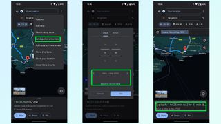
Traffic levels are always dependent on when you’re actually on the road, and predicting that by yourself is pretty much impossible. Fortunately Google Maps has libraries of historic traffic data at its disposal, and can estimate what traffic levels on your route will be like at specific parts of the day.
Just punch in your destination and hit Directions. The route preview screen will pop up, at which point you need to hit the three dot menu and tap the set depart or arrive time option. Set the time and day you plan on traveling, and Google Maps will give you a rough idea of how long the trip will take and what the traffic levels will be like along your route. So if they’re bad, you can alter your schedule to something a little more reasonable.
Sign up to get the BEST of Tom’s Guide direct to your inbox.
Upgrade your life with a daily dose of the biggest tech news, lifestyle hacks and our curated analysis. Be the first to know about cutting-edge gadgets and the hottest deals.
3. Add extra stops
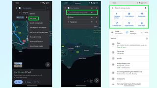
Need to go to multiple locations on your drive? You can add them all to a trip on Google Maps, either before or after you set off driving. Before is nice and easy: type in your final destination and press Directions. Once the route preview screen is open, press the three-dot menu followed by Add Stop. You can then search for places to add to the trip, be it a restaurant, gas station or something else. Just make sure to rearrange the order by pressing and holding the two parallel lines icon at the end of each stop.
The easiest way to add stops mid-drive is with voice commands. Ask Google Maps to add a gas station and it’ll show you a bunch of options. Tap the one you want on screen and Google Maps will add it to your trip after a few seconds. Alternatively press the magnifying glass at the top of the screen and you’ll be able to type in what you want — or choose from a number of popular pre-set options.
4. Share location and trip progress
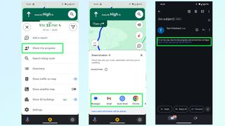
If there’s someone waiting at the end of your drive, or you want someone back home to know you’ve arrived safely, then you can share your trip progress with Google Maps. Once navigation is active, swipe up the bottom menu and select Share trip progress.
Pick a contact to send it to — be it an email, text message or any number of other options — and the recipient will be sent a message with a Google Maps link. Opening this link shows them where you are in real time, what your estimated time of arrival is, and what route you’ll be taking. There’s also a battery life toggle, and sharing will automatically stop once you reach your destination — though you can switch it off anytime from the drag-up menu.
5. Offline mapping
You can’t always guarantee that there’s going to be any cell signal where you’re going, and you don’t want to be cut off from your navigation system just because Google Maps lost its data connection. Fortunately Google Maps will let you download routes and maps for offline usage.
The good news is that Google Maps will automatically download a route as soon as you pump in your final destination — so you won’t lose directions mid-way through a drive. However this doesn’t account for times you need to make a diversion, or need to move onto a different spot after you arrive in a dead spot. So, you can download mapping data for a much larger region.
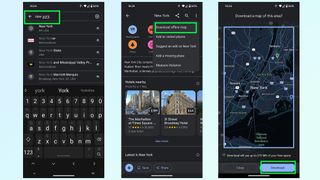
Simply search for an area or city, any area or city you like, and pull up the bottom menu. From there tap the three button menu in the top-right and choose Download offline map. This brings you to a map with a large blue square around it, which marks the area you’ll be downloading mapping data from. Zoom in and out, or move this box around to cover a different area and hit Download once you’re done.
6. Reserve a table or a hotel
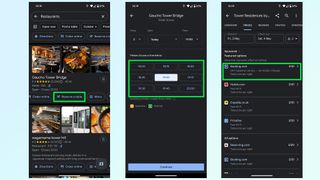
Not only does Google Maps include the ability to find restaurants and hotels, it also lets you check availability on any given day and book yourself a table or room from within the app itself.
Typically, trying to book something takes you to a third party website, be it a businesses official site or a third party booking service like Experia or OpenTable. However some of these businesses let you make reservations without having to leave Google Maps — saving you a little bit more time in the process.
7. Avoid tolls, ferries and highways
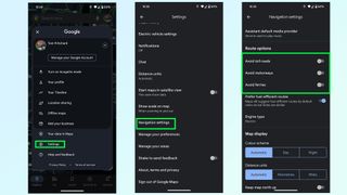
Unless explicitly told otherwise, Google Maps will direct you down what it considers to be the best possible route — which is usually either the fastest or shortest option available. But that may send you to some places you don’t want to be. Whether you’re skipping the cost of toll roads or ferries, or would rather a more scenic route than highways can offer.
Thankfully it’s very easy to tell Google Maps to avoid one or all of these things. Simply open up the Settings menu and scroll down until you find Navigation settings. The menu will give you a bunch of options, and you want to scroll down until it says Route Options.
Here you can tell Google Maps to avoid toll roads, highways and ferries. Toggle them on, and then head back to the main screen to get your directions.
8. Fuel-efficient routing
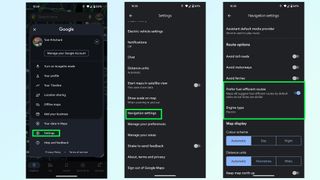
Gas is expensive, and EV charging takes a long time — even at a rapid charger. The last thing you want is to take some convoluted route that burns through more fuel than absolutely necessary.
Fortunately Google Maps is able to figure out the most energy efficient route for your car, based on the kind of fuel you use. Head to the Google Maps Settings menu then scroll down to Navigation settings. Scroll down this menu until you find Route Options and underneath the toggles to avoid tolls and highways is an option called Prefer fuel-efficient routes.
This should be enabled by default, but it pays to make sure it is switched on. Right below is an option called Engine type which will let you choose between Gasoline, diesel, electric and hybrid — because different engines’ efficiency varies depending on the kind of road you’re on.
9. Save your parking spot
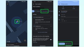
Nothing is worse than being lost in a parking lot, unable to find your car. So make sure to take advantage of this Google Maps feature that will save the location of your parking space and stop that disaster from happening. Once you park up simply hit the Blue dot that represents you on the map itself and tap the Save parking button on the menu.
Google Maps then drops a yellow pin with a large P in the center, marking your parking spot. This spot will also be saved in your recent history, and appears at the top of the menu when you tap the search bar. Simply tap that and Google Maps will fly to it, and give you the option to get directions to that spot.
More from Tom's Guide
- Google Maps is getting a big upgrade in time for your summer vacation
- Google Maps vs. Apple Maps: Which navigation app is best?
- 9 hidden Google Maps features everyone should know
Tom is the Tom's Guide's UK Phones Editor, tackling the latest smartphone news and vocally expressing his opinions about upcoming features or changes. It's long way from his days as editor of Gizmodo UK, when pretty much everything was on the table. He’s usually found trying to squeeze another giant Lego set onto the shelf, draining very large cups of coffee, or complaining about how terrible his Smart TV is.
7 biggest app annoyances — here’s what drives us up a wall with mobile apps
Google Maps is getting a makeover — here's everything you need to know
7 best music documentaries to stream right now
Most Popular
- 2 iPadOS 18: Release date rumors, expected new features and more
- 3 I used the MSI Claw as my only gaming console for an entire week, and I'm shocked by what happened
- 4 Google Pixel 8a last-minute rumors — 4 things you need to know
- 5 5 top new movies to stream this week on Netflix, Max and Hulu and more (May 7-13)
- 2 I used the MSI Claw as my only gaming console for an entire week, and I'm shocked by what happened
- 3 Google Pixel 8a last-minute rumors — 4 things you need to know
- 4 5 top new movies to stream this week on Netflix, Max and Hulu and more (May 7-13)
- 5 The iPad Pro 2024 could be a legitimate laptop replacement — here's 3 reasons why

- Acts of Kindness
- Viral Stories
- New Food Flavors
- Cleaning & Organization
- Kitchen Gadgets
- DIY & Improvement
Google Maps will soon make it easier to take the train
Google's update will bring up train times when you search for flights and let you quickly book a seat.
- Tod Caviness
- April 26, 2024
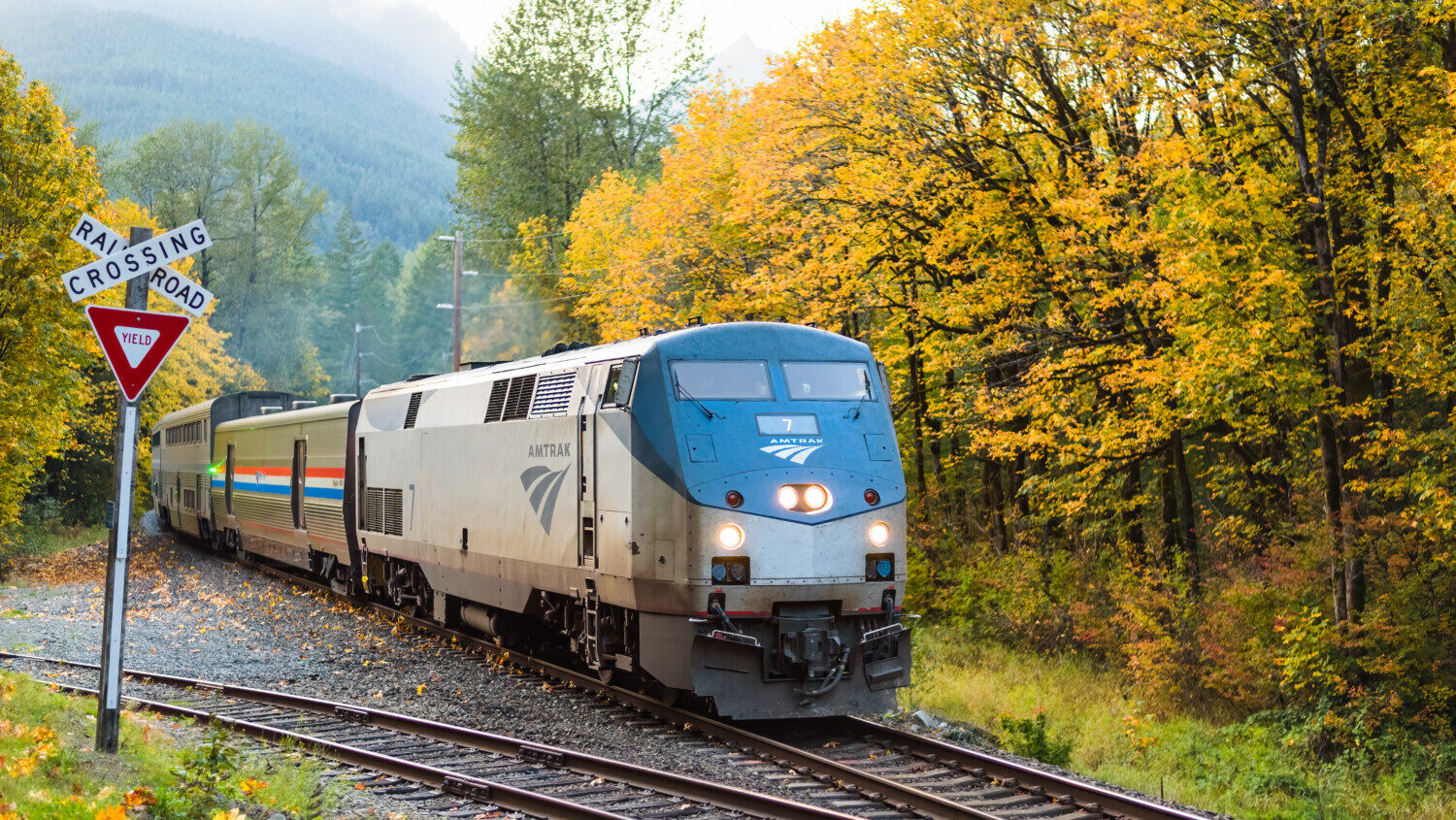
Train travel isn’t always the first option people think of when it comes to planning a trip. Part of that is awareness, and Google is doing their part to raise it in a big way with a new update to their Maps app. Soon, some travelers will be able to see information on train routes at a glance when they search for directions.
Google announced the changes last week in an initiative aimed at helping commuters and vacationers find more eco-friendly ways to get around.
MORE: This Google Maps feature helps you plan your stops and share your travel plans
“When it comes to traveling and commuting, we want people to have the right information to make more sustainable choices,” said James Byers, Group Product Manager for Google.
In 38 countries, including the U.S., you can already find train routes when you search specifically for them, but Google will be bringing up those options along with bus travel times when you search for flights . You’ll be able to see the ticket prices and schedules along with those times, as well as links that let you quickly book a seat.
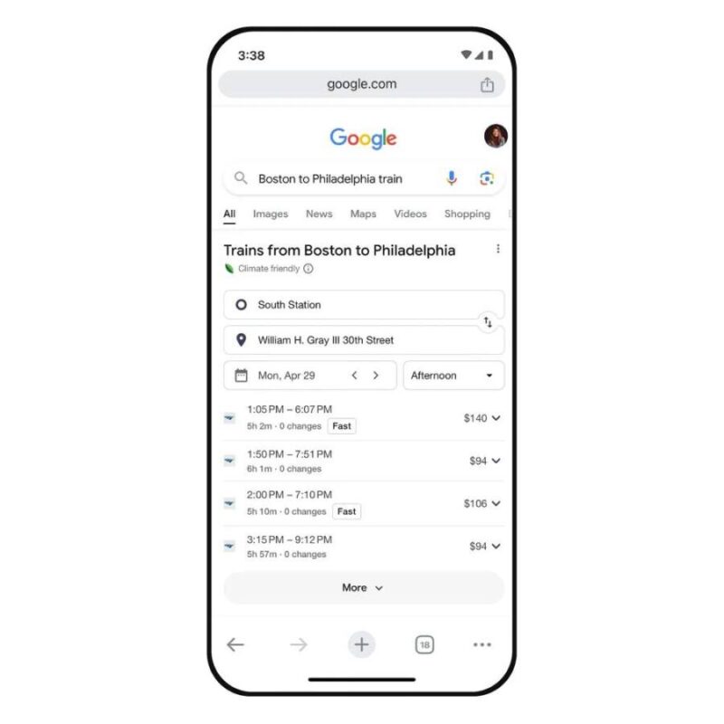
In 15 big cities around the globe, Google is taking those highlights a step further. When travelers search for driving directions, the results will bring up train travel times, bus routes and walking directions if those options are comparable. Berlin, London, Sydney, Montreal, Paris and Rome are among the metro areas where Maps users will see the changes in the next few weeks.
MORE: You can travel across the country by train for less than $500

By and large, train travel has a far lower ecological impact than flying by plane. Studies have long shown that a fully-booked train puts out roughly half the emissions that a plane does, and that accounts for older trains that run on diesel fuel. Those that run on electric rail (like most Amtrak routes in the Northeast Corridor) reduce those impacts even further.
Pro tip for eco-conscious flyers: Google already lets you see carbon emission estimates on flights so that you can sort your options sustainably.
Related posts

How to prevent lost luggage and avoid all that arrival stress
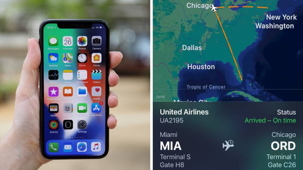
This easy iPhone trick lets you track flight info without an app
This Google Maps feature helps you plan your stops and share travel plans

How to stay safe in a hotel room
About the author.
From our partners

IMAGES
VIDEO
COMMENTS
As intuitive as Google Maps is for finding the best routes, it never let you choose departure and arrival times in the mobile app. This feature has long been available on the desktop site, allowing you to see what traffic should be like at a certain time and how long your drive would take at a point in the future. Fortunately, Google has finally added this feature to the app for iPhone and ...
Predictive travel time uses historical time-of-day and day-of-week traffic data to estimate travel times at a future date. This makes it easier than ever to predict how long it will take to get somewhere and suggest the best route even when the departure time is far in the future. Since traffic conditions in the future will vary greatly, we ...
Every day, over 1 billion kilometers are driven with Google Maps in more than 220 countries and territories around the world. When you hop in your car or on your motorbike and start navigating, you're instantly shown a few things: which way to go, whether the traffic along your route is heavy or light, an estimated travel time, and an estimated time of arrival (ETA).
Predictive travel time uses historical time-of-day and day-of-week traffic data to estimate travel times at a future date. This makes it easier than ever to ...
Google says using DeepMind's AI tools have improved the accuracy of ETAs in Maps by up to 50 percent. Image: Google. All this information is fed into neural networks designed by DeepMind that ...
Planning journeys ahead of time has always been difficult, since traffic conditions vary greatly over time. Developers have used live traffic data from the Google Maps APIs for years to help drivers with this problem, but up to now, this has been available only for journeys starting very close to now, and limited to Google Maps for Work customers only.
On your Android phone or tablet, open the Google Maps app . At the bottom, tap Go . Search for your destination in the search bar at the top. At the bottom, tap on 'Directions'. At the top, select your transportation mode. Select your preferred route. At the bottom, tap Pin . You can pin your trip and find it back in the Go tab next time you ...
Google Maps is good at telling you roughly how long it will take you to get to your next destination — even days or weeks in advance. ... Predictive travel time uses historical time-of-day and ...
Not any more. A new feature in the Maps APIs called predictive travel times, will use historical time-of-day and day-of-week traffic data to estimate travel times at a future date. This makes it easier than ever to predict how long it will take to get somewhere and suggest the best route even when the departure time is far in the future.
Twindesign/123RF. Google Maps has added a helpful feature to navigation that should make it a little easier to plan your next journey. The app will now tell you how long your travel time may be ...
On your computer, open Google Maps. Make sure you're signed in. On the left, choose an option: Get directions to relevant places: Click a place in the list. You'll get places based on your Gmail, Calendar, and recent travel history. Get directions to saved places: If you saved your work or home address in your Google Account, click Home or ...
DeepMind today detailed a collaboration with Google that reportedly improved the accuracy of real-time driving ETAs in Google Maps and Google Maps Platform APIs by up to 50% in some regions ...
To receive predicted travel times with traffic, specify a departure time of "now" or some time in the future, with a travel mode of driving. You can also specify a traffic model of optimistic, pessimistic, or best guess (default), to influence the assumptions used when calculating the travel time. For details, see the developer's guide.
Google Maps and Google Maps APIs have played a key role in helping us make these decisions, both at home and at work. Today, we're bringing predictive travel time - one of the most powerful features from our consumer Google Maps experience - to the Google Maps APIs so businesses and developers can make their location-based applications ...
To see the prediction of the traffic, First, open the Google Maps app on your Android Smartphone. Tap the Directions button on the bottom right. Now, enter the starting point and destination details in the input fields to generate a route for your commute. You'll see the real-time traffic patches in red on the blue route.
Find local businesses, view maps and get driving directions in Google Maps.
With the Distance Matrix API, you can provide travel distance and time for a matrix of origins and destinations. You can specify several options, including mode of transportation, such as driving, biking, transit or walking, as well as transit modes, such as bus, subway, train, tram, or rail. The Distance Matrix API provides information based ...
25. Yep, this is definitely possible using the API. You can construct a GDirections object without a map or directions div. You can do a load request from A to B and then call the getDuration method to get the total travel time. First you need to create a directions object: // no need to pass map or results div since.
At the bottom, tap Go . Search for your destination in the search bar at the top. At the bottom, tap on "Directions.". At the top, select your transportation mode. Select your preferred route. At the bottom, tap Pin . You can pin your trip and find it back in the Go tab next time you need it. Tip: Pinning only works with "Driving" and ...
Choose the best route for your drivers and allocate them based on real-time traffic conditions. Plus, display real-time traffic along a route. Get more accurate route pricing based on toll costs by pass or vehicle type, such as EV or hybrid. Optimize up to 25 waypoints to calculate a route in the most efficient order.
Predictive travel time uses historical time-of-day and day-of-week traffic data to estimate travel times at a future date. This makes it easier than ever to predict how long it will take to get somewhere and suggest the best route even when the departure time is far in the future. Since traffic conditions in the future will vary greatly, we ...
I want to find a travel time (including traffic) between two addresses. Inputs - origin, destination, arrival time, mode of transportation, traffic model (pessimistic, optimistic, best guess) Output - Travel time. It looks like the Google Distance Matrix API is the API I should be using for this except that I am not able to add an input of arrival time for driving.
To specify a traffic type. Set your origin and destination. If your departure time is in the future, include the time using the departure_time parameter. If you don't specify a departure time, it defaults to now. Select the traffic model to use with the trafficModel parameter and one of the following types: BEST_GUESS (default) to request that ...
Plan with a bird's-eye view in Immersive Mode. One of Google Maps' newer features is the immersive view. It combines high-quality satellite photos with Street View imagery, using artificial ...
I'm a nerd for maps. As a kid, they inspired me to want to travel, and as an adult they're my comfort reading. My colleagues at Afar even let me make a podcast episode about them. But of all the maps I love (Middle-earth included), the one I spend the most time with these days is Google Maps. I'm betting most of you can say the same thing.
However some of these businesses let you make reservations without having to leave Google Maps — saving you a little bit more time in the process. 7. Avoid tolls, ferries and highways
Google. In 15 big cities around the globe, Google is taking those highlights a step further. When travelers search for driving directions, the results will bring up train travel times, bus routes ...