- Latest News
- Emergencies
- Ask the Law
- GN Fun Drive
- Visa+Immigration
- Phone+Internet
- Reader Queries
- Safety+Security
- Banking & Insurance
- Dubai Airshow
- Corporate Tax
- Top Destinations
- Corporate News
- Electronics
- Home and Kitchen
- Consumables
- Saving and Investment
- Budget Living
- Expert Columns
- Community Tips
- Cryptocurrency
- Cooking and Cuisines
- Guide to Cooking
- Art & People
- Friday Partner
- Daily Crossword
- Word Search
- Philippines
- Australia-New Zealand
- Corrections
- From the Editors
- Special Reports
- Pregnancy & Baby
- Learning & Play
- Child Health
- For Mums & Dads
- UAE Success Stories
- Live the Luxury
- Culture and History
- Staying Connected
- Entertainment
- Live Scores
- Point Table
- Top Scorers
- Photos & Videos
- Course Reviews
- Learn to Play
- South Indian
- Arab Celebs
- Health+Fitness
- Gitex Global 2023
- Best Of Bollywood
- Special Features
- Investing in the Future
- Know Plan Go
- Gratuity Calculator
- Notifications
- Prayer Times

UAE announces Eid Al Fitr 2024 prayer timings
- Environment
The special prayer is held shortly after sunrise in each emirate

Dubai: The General Authority of Islamic Affairs and Endowments in the UAE has officially declared the prayer timings for Eid Al Fitr, which will be marked on Tuesday or Wednesday, depending on moon sighting.
Get exclusive content with Gulf News WhatsApp channel
Taking to their X platform account, the Authority shared the Eid prayer schedule for all emirates (and some major regions), ensuring that worshippers across the country know when to gather for this significant prayer.
Eid prayer timings
- Abu Dhabi: 6:22 AM
- Dubai: 6:20 AM
- Sharjah and Ajman: 6:17 AM
- Ras Al Khaimah: 6:15 AM
- Fujairah (and Khorfakkan): 6:14 AM
- Umm Al Quwain: 6:13 AM
Other regions:
- Al Ain: 6:15 AM
- Zayed City: 6:26 AM
What is Eid Al Fitr prayer?
Eid Al Fitr prayer marks the end of Ramadan, the month of fasting, and is a key component of the Islamic celebration of Eid Al Fitr, which translates to ‘Festival of Breaking the Fast’. This prayer is held in large congregations across the Muslim world, in mosques or open grounds.
Check out when Dubai parks will open during Eid
- Eid Al Fitr 2024 in UAE: Security plans announced in Ras Al Khaimah
- Dubai ready for Eid Al Fitr cannon firing at 7 locations
How is it performed?
The Eid Al Fitr prayer is distinct in that there is no adhan (call to prayer). It consists of two Rak’ahs (units of prayer) but is preceded by seven Takbirs (saying “Allahu Akbar”, which means “God is the Greatest”) in the first Rak’ah and five in the second, following the opening Takbir. The Imam (prayer leader) delivers a sermon (Khutbah) after the prayer, which attendees are encouraged to listen to, although it is not mandatory.
More From UAE

Eid Al Fitr 2024: UAE confirms first day of Eid

30 orphans gifted Eid clothes, treated to fun events

Dh2b housing benefits provided to Emiratis in Abu Dhabi

April 8 solar eclipse: What UAE residents need to know

63 Huskies from UAE wait to be rehomed in cooler climes
Eid dining delights: your guide to celebratory feasts, eid gift guide 2024: luxury finds for your loved ones, jadeja helps chennai end kolkata’s ipl winning run, uae fatwa council allows giving zakat al fitr in cash, 'birds of goodness' executes 28th relief aid in gaza.

Get Breaking News Alerts From Gulf News
We’ll send you latest news updates through the day. You can manage them any time by clicking on the notification icon.
Check Your Route Before You Start Your Journey | Conditions of Operation Database for QLD

Read time: 2 mins
All oversize overmass heavy vehicles/combinations travelling on state-controlled roads in Queensland must comply with the Conditions of Operation Database.
Click here for the Conditions of Operation Database
The Conditions of Operation Database is a database of road, structure and travel conditions and restrictions maintained by TMR.
Conditions and restrictions may include:
- bridge and roadside furniture clearances
- curfews and closures
- mass restrictions for bridges and culverts
- roadworks, lane closures and detours
- Traffic Management Plan requirements.
The conditions and restrictions in the database have been compiled from the most recent information practically available. All care is taken in providing this information. However, due care still needs to be taken when operating vehicles, particularly those in excess of regulation mass and/or dimension.
Check your route before you start your journey You must check the Conditions of Operation Database before you start your journey.
Conditions can change quickly We are continuously monitoring, assessing and reviewing our roads, bridges and culverts across Queensland. Conditions can change quickly, particularly due to weather. Restrictions are implemented to maintain ongoing safety for all road users.
Your responsibility under the Heavy Vehicle National Law It is your responsibility to make sure you’re using up-to-date information when you assess the suitability of your route.
Heavy Vehicle (Mass, Dimension and Loading) National Regulation Schedule 8, Part 1, Division 1 – 11 Assessing routes
(1) Before a class 1 heavy vehicle is driven along any route, its driver and operator must be satisfied that the route has been assessed and that the vehicle can be driven along it without contravening subsection (2).
(2) A class 1 heavy vehicle must not be driven along a route if to do so would be likely to cause— (a) disruption to telecommunication, electricity, rail, gas, water or sewage services (relevant services); or (b) damage to a road (including a bridge), structure, rail crossing or tree (relevant property).
(3) Subsection (2) does not apply if the entity responsible for the relevant services or relevant property has given permission for the vehicle to travel along the route, and the vehicle is driven in accordance with the permission.
(4) To remove any doubt, it is declared that a mass or dimension exemption is not permission for the purpose of subsection (3).
Find the Conditions of Operation Database on our website Visit www.tmr.qld.gov.au and select Business and Industry > Heavy vehicles > Queensland excess mass and dimensions > Conditions of Operation Database.
Further information and resources QLDTraffic provides state-wide information on road conditions, including incidents and hazards, closures and restrictions, roadworks and special events. The website also provides access to web cameras that relay near real-time traffic imagery. Visit the website, download the app or call 13 19 24 to report an incident or get real-time traffic reports.
Bridge and culvert restrictions interactive maps are updated regularly. Subscribe to our mailing list to be the first to know when changes are made to the bridge and culvert restrictions.
Queensland Access Condition Guide provides conditions for the movement of oversize heavy vehicles and combinations carrying indivisible items, special purpose vehicles and special purpose combinations.
Do you have questions? If you have questions about the Conditions of Operation Database or need help planning your journey call the Heavy Vehicle Access team on 07 3066 5511 or email [email protected] .
- Published on: May 18, 2021
- Category: News
- COVID-19 Updates
- From the Desk of CEO / Chair
- Media Releases
Related Posts

Key Changes to Telematics

Don’t get caught by 3G shutdown
From the CEO: Road access changes must be accelerated in the May Federal Budget
Helpful links, contact details.
- 1800 272 144
- 02 6295 3000
- Level 3/73 Northbourne Avenue, Canberra ACT 2601
- PO Box 3656, Manuka ACT 2603
- [email protected]
- Open hours: 8.30am - 5:00pm
- ACN: 066 531 913
What are you looking for?
How can we help you today?
Popular searches.
- Contactless payments
- Routes and timetables
- Concessions
- School student travel
- Opal Travel app

Services partially resume on the South Coast Line as roads and public transport recovery continues Services partially resume on the South Coast Line as roads and public transport recovery continues

Trackwork on the T3 Bankstown Line Trackwork on the T3 Bankstown Line

Anzac Day Dawn Service & March Anzac Day Dawn Service & March
Sydney CBD Sydney CBD
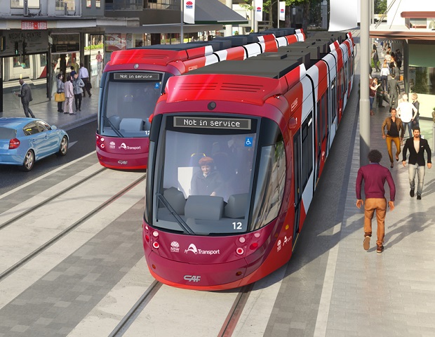
Parramatta Light Rail is now being tested Parramatta Light Rail is now being tested
Stay safe around the new light rail Stay safe around the new light rail

Getting Sydney back on track Getting Sydney back on track
View the latest rail repair trackwork updates View the latest rail repair trackwork updates
- Slide 1 of 5
- Slide 2 of 5
- Slide 4 of 5
- Slide 7 of 5
- Slide 8 of 5
- Lost property
- School transport

Open 11am | Close 6pm | Wednesday close 9pm
Biennale of Sydney - Rozelle
Plan your trip to the Biennale of Sydney at White Bay Power Station in Rozelle from Saturday 9 March to Sunday 10 June. Buses run regularly to the venue.

Gates Open 17:00 | NSW Cup Kick-Off 17:20 | NRL Kick-Off 19:50 | Full Time 21:50
NRL: Knights v Roosters
Plan your trip to see the Knights take on the Roosters on Thursday 11 April at McDonald Jones Stadium in Broadmeadow. Match tickets include travel on stadium shuttle buses.

Doors Open 17:00 | Start 18:10 | Finish 22:50
Bring Me The Horizon
Plan your trip to see Bring Me The Horizon on Friday 12 and Sunday 14 April at Qudos Bank Arena in Sydney Olympic Park.
Transport news

Services partially resume on the South Coast Line as roads and public transport recovery continues
Plan your trip or consider working from home, with major impacts still being experienced across the state’s road and public transport network following this weekend’s severe weather event.

Train timetable changes in April
From Saturday 13 April 2024, minor timetable adjustments will be made to Blue Mountains and Central Coast & Newcastle Lines.

Regional Rail Waste Collection Trial
Transport for NSW is trialling a new way to collect rubbish on regional train services as part of our commitment to reducing our environmental impact.
GUIDE: Everything to know about the solar eclipse in the Myrtle Beach area
MYRTLE BEACH, S.C. (WMBF) - April 8 is upon us, which means a total solar eclipse will soon be seen as the moon blocks the sun. While the path of totality isn’t the Carolinas, you should still be able to see a partial eclipse.

WHEN CAN I SEE THE ECLIPSE?
You should be able to see the eclipse beginning at around 2 p.m. and ending just after 4 p.m. The Grand Strand and Pee Dee will see 70% of the sun covered by the moon at the peak of the eclipse, which will only be for about four minutes.
Remember, if you’re planning to look at the eclipse - make sure to have special glasses or a viewer in order to do so. Regardless of if it’s covered by the moon or not, you’re still staring directly at the sun.
WANT A DEEP DIVE ON THE ECLIPSE?
Then check out a recent episode of our weather podcast, “Are You Cirrus?”!
First Alert Chief Meteorologist Jamie Arnold and First Alert Meteorologist Andrew Dockery talk in greater detail about the science behind the eclipse as well as watching it.
Monday is going to be a great day weather-wise for your viewing of the eclipse

We will finally reach back into the 70s tomorrow around the beaches and inland temperatures will sit in the low to mid 70s for the day. Any rain will stay off to our northwest so we will have a beautiful day on tap where we will stay rain-free and see a few higher-level cirrus clouds that will move in through the afternoon.
The cloud cover will be light so if you plan on viewing the eclipse you won’t have any issues.
WHAT ABOUT SCHOOLS?
Some schools in the Pee Dee have already announced they will be using Mondy as an eLearning Day due to the eclipse.
ARE THERE ANY VIEWING PARTIES?
Just across the state line, Robeson Community College is hosting a viewing party from 2-4 p.m. on its campus.
WHERE CAN YOU GET GLASSES?
In Myrtle Beach, The Market Common said it will have a limited number of glasses available at its management office on Monday.
The WMBF First Alert Weather Team also explained how you can make your own viewer at home using a shoebox and some other items!
WHEN’S THE NEXT ONE?
The next eclipse in the United States won’t occur until August 2044.
MORE ECLIPSE COVERAGE
- Eclipse expected to cause travel chaos; here’s how to navigate the roads and skies
- Drivers urged not to stop in the middle of road when the eclipse happens
- Keep an eye on your animals during the solar eclipse
- Companies roll out total solar eclipse promotions
Stay with WMBF News for updates.
Copyright 2024 WMBF. All rights reserved.

2 hurt in Horry County shooting, police say

Myrtle Beach-area nightclub owner promises changes after weekend shooting

1 dead, 2 displaced after fire in Longs

Morgan Wallen arrested for allegedly throwing chair off of roof
Latest news.

Person killed in Georgetown County crash

Georgetown man sentenced in 2023 bank robbery case

2 wanted in armed robbery at Darlington area lounge

Residents question fire safety after 2-alarm fire in Carolina Forest


National Heavy Vehicle Regulator
NHVR Portal

Road Access
- Agricultural vehicle permit
- B-double permit
- Class 3 (miscellaneous) permit
- Controlled Access Bus 12.5m-14.5m permit
- Higher Mass Limits permit
- Oversize Overmass permit
- Performance Based Standards vehicle access permit
- Road train permit
- Special Purpose Vehicle permit
- Tow truck permit
- Amend, cancel or replace permit
- Renew permit
- Do I need a permit?
- Emergency access
- Intelligent Access Program (IAP)
- Third party approvals
Access network changes
National network map.
- Getting started
- Access permits
- Benefits of heavy vehicle access
- Guidelines for granting access
- Network access
- PBS for road managers
- Route disruptions
- Strategic Local Government Asset Assessment Project
- Training and support
- 2.55m wide vehicles
- General Access Vehicle
- Concessional Mass Limits
- Rear overhang
- Higher Mass Limits
- Application process and forms
- Information for PBS Assessors and Certifiers
- Guidelines and rules
- Manage a PBS Vehicle Approval
- PBS contacts
- PBS Review Panel
- Generic Tyre Approach
- PBS Standards review
- Quad-axle group vehicle combinations
- Road and bridge access
- The Standards
- National heavy vehicle plates
- NHVR Portal Registration Services module
- NHVR Registration Checker app
Route Planner
NHVR Route planner
By using the NHVR Route planner tool you agree to the NHVR Portal - Terms of Use .
The NHVR Route Planner (also known as Journey Planner) is an interactive online mapping service. It maps and displays the following approved routes for use by heavy vehicles:
- Higher Mass Limits (HML)
- Performance-Based Standards (PBS)
- road trains
- some commodity routes.
Please note: The networks shown are indicative only and should be confirmed using the relevant state road transport authority mapping site .
You can use the Route Planner to help plan a heavy vehicle route and identify where an access permit application may need to be made. Routes can be saved and used as part of an application for an access permit .
Next Generation Route Planner
The Route Planner is now powered by Open Street Maps to allow access to accurate road data that can be updated in near real-time. The open data model of the base maps gives the ability to download routing information and use in spatial systems.
The Road Map for the new routing engine incorporates design for heavy vehicle travel rather than light vehicles. This will in turn assist with a more accurate General Access routing experience and minimise routing errors.
We are enhancing routing and mapping capabilities of the routing engine in stages. We want to deliver a nationally consistent, intelligent, route planning platform to assist the needs of the heavy vehicle industry.
User guide and learning material
- Route Planner Portal help articles
- Route Planner user guide (PDF, 6MB)
- Routing - Single route and area difference
- Single Trip, Period Permit and Multiple Trip - Information Sheet (PDF, 333KB)
Further support and resources is available in the NHVR Portal Help Centre .
State road transport authority mapping websites
- New South Wales
- South Australia
- Western Australia
Traffic advisory services
- ACT - Road closures
- NSW - Live Traffic NSW
- QLD - QLD Traffic
- SA - Outback Road Warnings
- SA - Traffic SA
- TAS - Community Alerts
- TAS - Road Closures and Delays
- VIC - VicTraffic
Notices and permit-based schemes
Users need to ensure they consult the relevant notices to identify all conditional and route requirements.
- National key freight routes map
The National key freight routes map is hosted by the Department of Infrastructure, Regional Development and Cities and provides a detailed picture of the road and rail routes connecting Australia's nationally significant places for freight, including ports, airports and intermodal terminals. The map provides a policy tool to inform strategic planning, operational and investment decisions across the Australian freight network.
Links to network suspension and amendments that have been gazetted by the NHVR.
Supports improved heavy vehicle access efficiency and decision-making by bringing together the state-based heavy vehicle networks and displaying them in one location.

- Rivers and Lakes
- Severe Weather
- Fire Weather
- Long Range Forecasts
- Climate Prediction
- Space Weather
- Past Weather
- Heating/Cooling Days
- Monthly Temperatures
- Astronomical Data
- Beach Hazards
- Air Quality
- Safe Boating
- Rip Currents
- Thunderstorms
- Sun (Ultraviolet Radiation)
- Safety Campaigns
- Winter Weather
- Wireless Emergency Alerts
- Weather-Ready Nation
- Cooperative Observers
- Daily Briefing
- Damage/Fatality/Injury Statistics
- Forecast Models
- GIS Data Portal
- NOAA Weather Radio
- Publications
- SKYWARN Storm Spotters
- TsunamiReady
- Service Change Notices
- Be A Force of Nature
- NWS Education Home
- Pubs/Brochures/Booklets
- NWS Media Contacts
NWS All NOAA
- Organization
- Strategic Plan
- Commitment to Diversity
- For NWS Employees
- International
- National Centers
- Social Media
- Strong and Damaging Winds from April 6th through April 7th, 2024
- Denver's March 2024 Climate Summary
- 2024 Spotter Training Classes
Privacy Policy
Denver/Boulder, CO
Weather Forecast Office
April 8, 2024 Solar Eclipse and Cloud Cover Forecasts
- Storm and Precipitation Reports
- Submit a Storm Report
- Experimental Graphical Hazardous Weather Outlook
- Snowfall Analysis
- Observations
- Local Storm Reports
- Local Snowfall Reports
- Local Ice Accumulation Reports
- Observed Precipitation
- Local Enhanced Radar
- Local Standard Radar (low bandwidth)
- Regional Standard Radar (low bandwidth)
- Hourly Forecasts
- Activity Planner
- User Defined Area Forecast
- Forecast Discussion
- Avalanche Weather Information
- National Water Prediction Service (NWPS)
- NOAA Climate Service
- Event Summaries
- Drought Determination
- Local Climate
- Preparedness
- SKYWARN Spotters
- Text Products
- Colorado Avalanche Hazards
- Weather History
- Flood After Fire
- Resources for Outdoor Events
- Awareness Weeks
- Student Volunteering
- El Nino-Southern Oscillation
A total solar eclipse will occur Monday, April 8, 2024, stretching from south central Texas through the Ohio Valley and then into the New England. Here is the latest forecast information regarding expected cloud cover, in relationship to the path of totality and partial eclipse. These will be updated daily around 1130 am MDT.
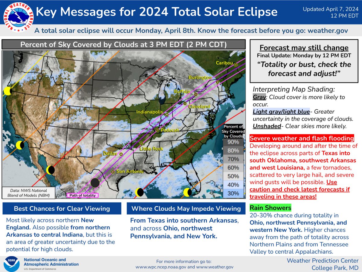
Interactive cloud forecasts available and updated 24/7 are available here . (Use the time scroll bar toward the top of that page, and pan to area of interest).
Further information about the 2024 Solar Eclipse from NASA and the US Naval Observatory .
Can't make this one? If you're in Colorado, you'll only have to wait until August 12, 2045 .
HAZARDS Current Hazards Enhanced Decision Support SPC Outlooks
FORECASTS Forecast Discussion Fire Weather Aviation Text Products
CURRENT CONDITIONS Current Observations
PAST WEATHER RECORDS Weather Records On this day in Wx History Local Climate Plots
WEATHER SAFETY SkyWarn NOAA Wx Radio
OFFICE ACTIVITIES Historical Observation Sites Cooperative Program
US Dept of Commerce National Oceanic and Atmospheric Administration National Weather Service Denver/Boulder, CO 325 Broadway Boulder, CO 80305-3328 303-494-3210 for a recording call 303-494-4221 Comments? Questions? Please Contact Us.

You'll never travel without our trip planner again
Travel planning at its best. build, organize, and map your custom itineraries in a free travel app designed for vacations & road trips, powered by our trip planner ai.

Your itinerary and your map in one view
No more switching between different apps, tabs, and tools to keep track of your travel plans.
What travelers are raving about
Features to replace all your other tools, add places from guides with 1 click, collaborate with friends in real time, import flight and hotel reservations, expense tracking and splitting, checklists for anything, get personalized suggestions, plan like a pro.
Unlock premium features like offline access, unlimited attachments, flight deals, export to Google maps, and much more
Offline access
Unlimited attachments, optimize your route.
4.9 on App Store, 4.7 on Google Play
Discover your next favorite destination
Have tips of your own? Write a guide to share with other travelers like you!
Ready to plan your trip in half the time?
For every kind of trip and every destination, the best road trip planner, the best vacation planner, the best group itinerary planner.
Account Options
- Plan a Road Trip
- Plan a Flight
- Find an Airport
- Where to Stay
- All Questions
Road trip planner
Starting City
Destination City
Or switch to flying
Planning a road trip?
Get advice from people who have done the same trip.
The Trippy road trip planner automatically calculates the optimal itinerary including stops recommended by Trippy members, favorite restaurants and hotels, local attractions and things to do based on what people who live in the area have suggested, and more.
Once you have a quick trip planned, you can customize every detail, adding or removing stops, or changing what time you leave in the morning or how long you stay at each stop. Then you can save your custom trip and share it with friends and family.
Let us know if you have requests for more features you'd like to see in the trip planner!
Plan a journey results
- News and media
- Commercial opportunities
- Procurement
- Privacy policy
- Accessibility statement
- Modern slavery statement
- Help and contact us
- Where to find us
- Safe and secure travel

IMAGES
VIDEO
COMMENTS
Use journey planner to plan your travel across the Translink network of bus, train, ferry and tram services.
On occasion, roads can be closed or have their access conditions changed. For road closures and up-to-date traffic conditions visit QLD Traffic or call 13 19 40 . Approved Queensland heavy vehicle route maps and restrictions can be accessed through: NHVR National Network Map. Queensland Globe.
Journey planner provides detailed public transport information and maps right across Victoria.
Plan your journey. Use our journey planner, timetables and MyTranslink app to help you reach your destination. They're easy-to-use and can take the stress out of catching public transport. We also run special services on event days and after hours. Remember to plan ahead: check when these special services operate, how often they run and where ...
The special prayer is held shortly after sunrise in each emirate. Dubai: The General Authority of Islamic Affairs and Endowments in the UAE has officially declared the prayer timings for Eid Al ...
TfL fares frozen until March 2025. Find out more about fares. Plan your journey across the TfL network. Journey planner for Bus, Tube, London Overground, DLR, Elizabeth line, National Rail, Tram, River Bus, IFS Cloud Cable Car, Coach.
State-controlled roads and regions. State-controlled roads and region maps enable users to identify relationships between roads, railways, local government areas, towns, cities and the department's engineering and administrative regions. Information and guides for all vehicles to help you navigate our roads throughout Queensland.
Transport for Ireland Journey Planner
The Conditions of Operation Database is a database of road, structure and travel conditions and restrictions maintained by TMR. Conditions and restrictions may include: bridge and roadside furniture clearances; curfews and closures; mass restrictions for bridges and culverts; roadworks, lane closures and detours; Traffic Management Plan ...
From Sunday 31 March, timetables and routes for some Northern Beaches and North shore buses will be adjusted to improve reliability and capacity to meet customer demand. Transport and travel information to help you plan your public transport trip around NSW by metro, train, bus, ferry, light rail and coach. Trip Planner, travel alerts, tickets ...
You should be able to see the eclipse beginning at around 2 p.m. and ending just after 4 p.m. The Grand Strand and Pee Dee will see 70% of the sun covered by the moon at the peak of the eclipse ...
Waze is a community-driven navigation app that helps you find the best route to your destination, avoid traffic jams, and save time and money. Waze also offers carpooling options to share rides with fellow drivers. Download Waze and join millions of drivers who share real-time road information.
The review and update will result in the development of a consolidated Queensland Principal Cycle Network Plan with accompanying priority route maps. The consolidated plan will be available following endorsement by TMR and local governments. For now, please continue to refer to the current Principal Cycle Network Plans below. View the plans
The NHVR Route Planner (also known as Journey Planner) is an interactive online mapping service. It maps and displays the following approved routes for use by heavy vehicles: some commodity routes. Please note: The networks shown are indicative only and should be confirmed using the relevant state road transport authority mapping site.
A total solar eclipse will occur Monday, April 8, 2024, stretching from south central Texas through the Ohio Valley and then into the New England. Here is the latest forecast information regarding expected cloud cover, in relationship to the path of totality and partial eclipse. These will be updated daily around 1130 am MDT.
Use Wanderlog to share your itinerary with tripmates, friends, and families and collaborate in real time, so everyone stays in the loop. Plan your road trip or vacation with the best itinerary and trip planner. Wanderlog travel planner allows you to create itineraries with friends, mark routes, and optimize maps — on web or mobile app.
Free route planner and fleet management for HGV and truck. See fuel prices, toll costs and live location of drivers. Add multiple stops and share the ETA.
Journey planning—maps. If you are planning a driving holiday on Queensland roads—or to drive a long distance in Queensland to your holiday destination—you should plan your journey, including your route and stops, in advance. Queensland is a large state with many different landscapes, including rainforests, beaches and outback.
Trip Planner is a Google My Maps project that helps you plan your trips and share them with others. You can customize your map with markers, routes, photos, and descriptions of your destinations ...
The Trippy road trip planner automatically calculates the optimal itinerary including stops recommended by Trippy members, favorite restaurants and hotels, local attractions and things to do based on what people who live in the area have suggested, and more. Once you have a quick trip planned, you can customize every detail, adding or removing ...
Route Planner can optimize your route so you spend less time driving and more time doing. Provide up to 26 locations and Route Planner will optimize, based on your preferences, to save you time and gas money. One address per line (26 max) Add another stop. Stops. Let us re-order stops Round trip. Optimize for. Shortest time Shortest distance.
Plan your trip with MapQuest Route Planner, the easy way to find the best routes, avoid tolls and traffic, and save your favorites.
The Disability Action Plan 2018-2022 (the action plan) was released in 2018 to outline the Department of Transport and Main Roads' (TMR) commitment to making the passenger transport network more accessible for people with disability. The plan included 41 actions categorised by four themes connecting to each stage of a customer's journey ...
More. Plan a journey results. Due to the cracked rail on the approach to Victoria station, East Didsbury and Rochdale trams will not call at Exchange Square until further notice. View the latest travel information. This week our customer and social teams are here for you until 10pm. Whether you travel by bus, tram, train, walk, wheel or cycle ...
Personalised transport industry: taxi and booked hire. Industry information. Customer information. Information bulletins. Queensland's Personalised Transport Horizon.
The department's Interim Disability Action Plan 2023-2024 outlines our continued commitment to improve accessibility for people with disability using the passenger transport system in Queensland. Our Disability Action Plans contribute to the department's Disability Service Plan and Accessibility and Inclusion Strategy.